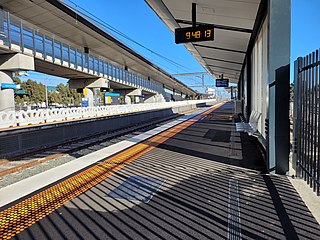
West Footscray railway station is a commuter railway station on the Sunbury line, which is part of the Melbourne railway network. It serves the western suburb of West Footscray, in Melbourne, Victoria, Australia. West Footscray station is a ground-level unstaffed station, featuring three platforms, an island platform with two faces and one side platform, accessible by a pedestrian footbridge. It opened on 1 October 1888, with the current island platform provided in 2013 and the current side platform provided in 2020.

Adelaide railway station is the central terminus of the Adelaide Metro railway system. All lines approach the station from the west, and it is a terminal station with no through lines, with most of the traffic on the metropolitan network either departing or terminating here. It has nine below-ground platforms, all using broad gauge track. The station is located on the north side of North Terrace, west of Parliament House.
Belair railway station is located on the Adelaide to Melbourne line in the Adelaide southern foothills suburb of Belair, 21.5 kilometres from Adelaide station. It is the terminus for Adelaide Metro's Belair line service.

Adelaide Parklands Terminal, formerly known as Keswick Terminal, is the interstate passenger railway station in Adelaide, South Australia. It is the only station in the world where passengers can board trains on both north–south and east–west transcontinental routes.

The Belair line is a suburban rail commuter route in the city of Adelaide, South Australia, that runs from the Adelaide station to Belair in the Adelaide Hills via the Adelaide-Wolseley line using diesel 3000/3100 class railcars. Prior to 1995, this part of Adelaide-Wolseley was a two-track broad gauge line. In 1995, Adelaide-Wolseley was converted to standard gauge meaning Adelaide to Belair is now effectively two separate single-track lines running in parallel: the Belair commuter line and the Adelaide-Wolseley standard gauge freight line.

Aldgate is a South Australian village and a suburb of Adelaide, located 21 km (13 mi) south-east of the Adelaide city centre, in the Adelaide Hills.

The State Transport Authority (STA) was the government agency which controlled public transport in South Australia between 1974 and 1994.

Salisbury railway station is a railway station and bus interchange in the northern Adelaide suburb of Salisbury. It is on the Gawler line, 20.2 kilometres (12.6 mi) from Adelaide station. Adjoining it is a large park & ride carpark, making it one of the busiest stations on the Adelaide suburban rail system.

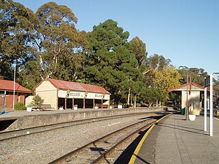
Benalla railway station is located on the North East line in Victoria, Australia. It serves the town of Benalla, and it opened on 18 August 1873.
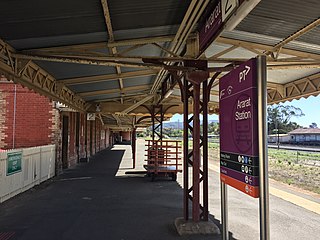
Ararat railway station is located on the Serviceton and Western standard gauge lines in Victoria, Australia. It serves the town of Ararat, and opened on 7 April 1875.
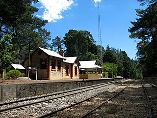
Mount Lofty Railway Station is located on the Adelaide-Wolseley line and served the Adelaide Hills suburb of Stirling. It is located 19+1⁄4 miles (31.0 km) from Adelaide station.
The Bridgewater railway line is a former passenger railway service on the Adelaide to Wolseley line in the Adelaide Hills. It was served by suburban services from Adelaide. On 26 July 1987, the service was curtailed to Belair and renamed Belair railway line. In 1995, the Adelaide-Wolseley line was converted to standard gauge as part of the One Nation infrastructure program, disconnecting the abandoned Bridgewater line stations from the broad gauge suburban railway system.

Carripook railway station was located on the Adelaide-Wolseley line serving the Adelaide Hills suburb of Bridgewater to the east of the Kain Avenue level crossing. It was located 36.3 km from Adelaide station, at an elevation of 396 metres (1,299 ft).

Aldgate railway station was located on the Adelaide-Wolseley line in the Adelaide Hills suburb of Aldgate, 34.9 kilometres from Adelaide station.

Jibilla railway station was located on the Adelaide-Wolseley line serving the Adelaide Hills suburb of Aldgate immediately east of the Yatina Road level crossing. It was located 36.0 km from Adelaide station.

Madurta railway station was located on the Adelaide-Wolseley line serving the Adelaide Hills suburb of Aldgate to the east of the Cricklewood Road level crossing. It was located 34.1 km from Adelaide station.

Heathfield railway station was located on the Adelaide-Wolseley line serving the Adelaide Hills suburb of Heathfield. It was located 33.2 km from Adelaide station, and at an elevation of 420 metres (1,380 ft)

Upper Sturt railway station was located on the Adelaide-Wolseley line serving the Adelaide Hills suburb of Upper Sturt. It was located 29.3 km from Adelaide station.
Long Gully railway station was located on the Adelaide-Wolseley line in the Belair National Park, South Australia. It was located 21.1 km from Adelaide station.
National Park railway station was a railway station in South Australia located on the Adelaide-Wolseley line in the suburb of Belair and within the boundaries of the Belair National Park. It was located 25.8 kilometres from Adelaide station.
