Related Research Articles

Cheddar is a large village and civil parish in the Sedgemoor district of the English county of Somerset. It is situated on the southern edge of the Mendip Hills, 9 miles (14 km) north-west of Wells, 11 miles (18 km) south-east of Weston-super-Mare and 18 miles (29 km) south-west of Bristol. The civil parish includes the hamlets of Nyland and Bradley Cross. The parish had a population of 5,755 in 2011 and an acreage of 8,592 acres (3,477 ha) as of 1961.

Somerset is a county in South West England which borders Gloucestershire and Bristol to the north, Wiltshire to the east, Dorset to the south-east and Devon to the south-west. It is bounded to the north and west by the Severn Estuary and the Bristol Channel, its coastline facing southeastern Wales. Its traditional border with Gloucestershire is the River Avon. Somerset is formed of six districts, of which two are unitary authorities and its county town is Taunton.

Bridgwater is a large historic market town and civil parish in Somerset, England. Its population currently stands at around 35,886 as of 2011. Bridgwater is at the edge of the Somerset Levels, in level and well-wooded country. The town lies along both sides of the River Parrett; it has been a major inland port and trading centre since the industrial revolution. Most of its industrial bases still stand today. Its larger neighbour, Taunton, is linked to Bridgwater via a canal, the M5 motorway and the GWR railway line.
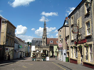
Shepton Mallet is a market town and civil parish in the Mendip District of Somerset, England, some 16 miles (26 km) south-west of Bath, 18 miles (29 km) south of Bristol and 5 miles (8.0 km) east of Wells. It had an estimated population of 10,810 in 2019. Mendip District Council is based there. The Mendip Hills lie to the north and the River Sheppey runs through the town, as does the route of the Fosse Way, the main Roman road between north-east and south-west England. There is evidence of Roman settlement. Its listed buildings include a medieval parish church. Shepton Mallet Prison was England's oldest, but closed in March 2013. The medieval wool trade gave way to trades such as brewing in the 18th century. It remains noted for cider production. It is the closest town to the Glastonbury Festival and nearby the Royal Bath and West of England Society showground.

The Somerset Levels are a coastal plain and wetland area of Somerset, England, running south from the Mendips to the Blackdown Hills.
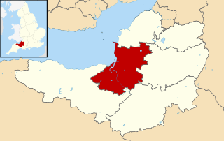
Sedgemoor is a low-lying area of land in Somerset, England. It lies close to sea level south of the Polden Hills, historically largely marsh. The eastern part is known as King's Sedgemoor, and the western part West Sedgemoor. Sedgemoor is part of the area now known as the Somerset Levels and Moors. Historically the area was known as the site of the Battle of Sedgemoor.
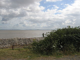
Bridgwater Bay is on the Bristol Channel, 5 kilometres (3.1 mi) north of Bridgwater in Somerset, England at the mouth of the River Parrett and the end of the River Parrett Trail. It stretches from Minehead at the southwestern end of the bay to Brean Down in the north. The area consists of large areas of mudflats, saltmarsh, sandflats and shingle ridges, some of which are vegetated. It has been designated as a Site of Special Scientific Interest (SSSI) covering an area of 3,574.1 hectares since 1989, and is designated as a wetland of international importance under the Ramsar Convention. The risks to wildlife are highlighted in the local Oil Spill Contingency Plan.

Athelstan Joseph Michael Eavis is an English dairy farmer and the co-creator of the Glastonbury Festival, which takes place at his farm in Pilton, Somerset.

The Mendip Hills is a range of limestone hills to the south of Bristol and Bath in Somerset, England. Running from Weston-super-Mare and the Bristol Channel in the west to the Frome valley in the east, the hills overlook the Somerset Levels to the south and the Chew Valley and other tributaries of the Avon to the north. The hills give their name to the local government district of Mendip, which administers most of the area. The higher, western part of the hills, covering 198 km2 (76 sq mi) has been designated an Area of Outstanding Natural Beauty (AONB), which gives it a level of protection comparable to a national park.
Somerset is a historic county in the south west of England. There is evidence of human occupation since prehistoric times with hand axes and flint points from the Palaeolithic and Mesolithic eras, and a range of burial mounds, hill forts and other artefacts dating from the Neolithic, Bronze and Iron Ages. The oldest dated human road work in Great Britain is the Sweet Track, constructed across the Somerset Levels with wooden planks in the 39th century BCE.

Brean Down is a promontory off the coast of Somerset, England, standing 318 feet (97 m) high and extending 1.5 miles (2 km) into the Bristol Channel at the eastern end of Bridgwater Bay between Weston-super-Mare and Burnham-on-Sea.

Shipham is a village and civil parish in Somerset, England. It is on the western edge of the Mendip Hills near the A38, approximately 15 miles (24 km) south of Bristol. It is in the local government district of Sedgemoor. The parish includes the village of Rowberrow and the hamlet of Star. The parish population, according to the 2011 census, is 1,087.
Local World Holdings Ltd. was a large regional newspaper publisher in the UK that published around 100 print titles and more than 70 websites. It was formed in 2012 by David Montgomery, a former chief executive of Trinity Mirror, to buy the Daily Mail and General Trust's Northcliffe Media business, and the Yattendon Group's Iliffe newspaper group.

Somerset is a county in the south west of England. It has a varied cultural tradition ranging from the Arthurian legends to The Wurzels, a band specialising in Scrumpy and Western music.

The earliest known infrastructure for transport in Somerset is a series of wooden trackways laid across the Somerset Levels, an area of low-lying marshy ground. To the west of this district lies the Bristol Channel, while the other boundaries of the county of Somerset are along chains of hills that were once exploited for their mineral deposits. These natural features have all influenced the evolution of the transport network. Roads and railways either followed the hills, or needed causeways to cross the Levels. Harbours were developed, rivers improved, and linked to sources of traffic by canals. Railways were constructed throughout the area, influenced by the needs of the city of Bristol, which lies just to the north of Somerset, and to link the ports of the far south-west with the rest of England.
The county of Somerset is in South West England, bordered by the Bristol Channel and the counties of Bristol and Gloucestershire to the north, and Wiltshire to the east, Dorset to the south, and Devon to the west. The climate, influenced by its proximity to the Atlantic Ocean and the prevailing westerly winds, tends to be mild, damp and windy.

Ham Wall is an English wetland National Nature Reserve (NNR) 4 kilometres (2.5 mi) west of Glastonbury on the Somerset Levels. It is managed by the Royal Society for the Protection of Birds (RSPB). Since the last Ice Age, decomposing plants in the marshes of the Brue valley in Somerset have accumulated as deep layers of peat that were commercially exploited on a large scale in the twentieth century. Consumer demand eventually declined, and in 1994 the landowners, Fisons, gave their old workings to what is now Natural England, who passed the management of the 260 hectares Ham Wall section to the RSPB.
References
- ↑ Blacklock, Daisy. "Bridgwater's first-ever Science Festival well underway". Somerset County Gazette. Retrieved 14 October 2015.
- ↑ "Science festival to return to Bridgwater". Bridgwater Mercury. 30 April 2015. Retrieved 27 March 2021.
- ↑ "Bridgwater Science Festival". Wells & Mendip Astronomers. Retrieved 18 April 2016.
- ↑ "Landscape Change in the Avalon Marshes". Avalon Marshes. Archived from the original on 1 April 2016. Retrieved 18 April 2016.
- ↑ "Bridgwater Science Festival attracts more than 1000 visitors". Bridgwater Mercury. 12 June 2015. Retrieved 18 April 2016.
- ↑ "Bridgwater Science Festival 2014". Somerset Archaeological and Natural History Society. Retrieved 18 April 2016.
- ↑ "Bridgwater Science Festival - Family Science Fair". Hey Events. Retrieved 18 April 2016.
- ↑ "Learn the secret science behind The Simpsons". Mid Devon Gazette. 27 May 2014. Archived from the original on 21 November 2014. Retrieved 12 October 2015.