
Studland is a village and civil parish on the Isle of Purbeck in Dorset, England. The village is located about 2 miles (3.2 km) north of the town of Swanage, over a steep chalk ridge, and 3 miles (4.8 km) south of the South East Dorset conurbation at Sandbanks, from which it is separated by Poole Harbour. The parish includes Brownsea Island within the harbour. In the 2011 census the parish had 182 households and a population of 425, though many of the houses in the village are holiday homes, second homes, or guest houses, and the village's population varies depending upon the season.

Bridport is a market town in Dorset, England, 2 miles (3.2 km) inland from the English Channel near the confluence of the River Brit and its tributary the Asker. Its origins are Saxon and it has a long history as a rope-making centre. On the coast and within the town's boundary is West Bay, a small fishing harbour also known as Bridport Harbour.
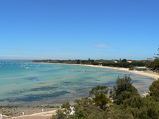
Sorrento is a coastal town on the Mornington Peninsula in Melbourne, Victoria, Australia, 103 km (64 mi) south-west of Melbourne's Central Business District, located within the Shire of Mornington Peninsula local government area. Sorrento recorded a population of 2,013 at the 2021 census.

West Bay, originally known as Bridport Harbour, is a small harbour settlement and resort on the English Channel coast in Dorset, England, sited at the mouth of the River Brit approximately 1.5 miles (2.4 km) south of Bridport. The area is part of the Jurassic Coast, a World Heritage Site.
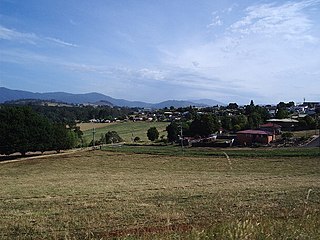
Scottsdale, formerly known as Ellesmere, is a town in the north-east of Tasmania, Australia. It lies on the Tasman Highway, around 63 kilometres (39 mi) north-east of Launceston and 22 km (14 mi) south-east of the coastal town of Bridport. It is part of the Dorset Council.

Cruden Bay is a small village in Scotland, on the north coast of the Bay of Cruden in Aberdeenshire, 26 miles (42 km) north of Aberdeen.
Indented Head is a small coastal township located on the Bellarine Peninsula, east of Geelong, in the Australian state of Victoria. The town lies on the coast of the Port Phillip bay between the towns of Portarlington and St Leonards.

St Leonards is a coastal township near Geelong, Victoria, Australia, at the eastern end of the Bellarine Peninsula and the northern end of Swan Bay. Situated 33 kilometres (21 mi) east of Geelong, St Leonards was a filming location for the Australian television series SeaChange.

Port Fairy is a coastal town in south-western Victoria, Australia. It lies on the Princes Highway in the Shire of Moyne, 28 kilometres (17 mi) west of Warrnambool and 290 kilometres (180 mi) west of Melbourne, at the point where the Moyne River enters the Southern Ocean.

Orford is a village on the east coast of Tasmania, Australia 73 kilometres north-east of Hobart. It is the home of the joint champions of T20 Cricket in Tasmania. The village is centred on the mouth of the Prosser River, on the southern margin of a substantial coastal inlet called Prosser Bay. Beyond this bay are the waters of the Mercury Passage. At the 2006 census, Orford had a population of 553.

Strand is a seaside resort town in the Western Cape, South Africa. It forms part of the Helderberg region of the City of Cape Town Metropolitan Municipality, situated on the north-eastern edge of False Bay and near the foot of the Helderberg Mountains. Its geographical position is between Somerset West and Gordon's Bay, and is about 50 km southeast of Cape Town City Bowl. Strand has a population of approximately 50,000. Strand's main attraction is the beach; 5 km of white sandy beach off False Bay.
Maharees or Magharees is a 5 km long tombolo located on the northern side of the Dingle Peninsula in County Kerry, Ireland.
Tom Doak is a golf course architect. He has 6 courses ranked among the top 100 in the world according to the "Top 100 Courses in the World" March 2021 list compiled by Golf Magazine. These include Pacific Dunes in Oregon, Ballyneal in Colorado, Barnbougle Dunes in Tasmania and Cape Kidnappers in New Zealand. Doak lives in Michigan.

Rhosneigr is a village in the south-west of Anglesey, north Wales. It is situated on the A4080 road. It is south-east of Holyhead, and is on the Anglesey Coastal Path. From the clock at the centre of the village can be seen RAF Valley and Mynydd Twr. The towns of Holyhead and Llangefni and the city of Bangor are all within easy travelling distance.
Bellingham is a rural locality in the local government area (LGA) of George Town in the Launceston LGA region of Tasmania. The locality is about 39 kilometres (24 mi) north-east of the town of George Town. The 2016 census has a population of 60 for the state suburb of Bellingham. It is a tiny coastal hamlet in northern Tasmania, situated on the mouth of the Pipers River directly opposite the town of Weymouth. The town is located 62 kilometres (39 mi) from Launceston, 20 kilometres (12 mi) from Bridport and 38 kilometres (24 mi) from George Town.

Port Neill is a small coastal town on the eastern side of the Eyre Peninsula, in South Australia about 3 km off the Lincoln Highway between the major towns of Whyalla and Port Lincoln. It is 576 km by road from Adelaide.
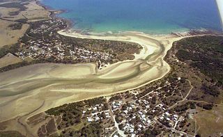
Barnbougle Dunes Golf Links is a golf course located near the seaside village of Bridport in Tasmania's North-East. The 18 hole championship layout was designed by course architects Tom Doak and Mike Clayton, and is set among sand dunes overlooking Bass Strait. The course has been highly rated since opening in 2005, recognised as Australia's number one public access course, and fifth best course of any sort in Australia. Barnbougle Dunes is the first new Australian course to enter the World's Top 100 courses since rankings began, coming in at 49 after its first appraisal. It has since improved to be ranked the 35th best course in the world, and is ranked the 12th best links course in the world.

Triabunna is a rural residential locality in the local government area (LGA) of Glamorgan–Spring Bay in the South-east LGA region of Tasmania. The locality is about 86 kilometres (53 mi) north-east of the city of Hobart. The 2021 census has a population of 905 for the state suburb of Triabunna.

Matarangi is a beach settlement on the Coromandel Peninsula of New Zealand, with around 420 permanent residents in 2018 which increases to over 7000 holidaymakers during the summer period of late December to February. It was developed in the 1980s as a purpose-built resort town and occupies a white sand peninsula between the Whangapoua Harbour and historic Mercury Bay. It is half an hour from the towns of Coromandel to the west and Whitianga to the south east.

