The Delta Works is a series of construction projects in the southwest of the Netherlands to protect a large area of land around the Rhine–Meuse–Scheldt delta from the sea. Constructed between 1954 and 1997, the works consist of dams, sluices, locks, dykes, levees, and storm surge barriers located in the provinces of South Holland and Zeeland.

Hellevoetsluis is a small city in the western Netherlands. It is located in Voorne-Putten, South Holland. The former municipality covered an area of 61.20 km2 (23.63 sq mi) of which 20.10 km2 (7.76 sq mi) was water and it included the population centres of Nieuw-Helvoet, Nieuwenhoorn, and Oude en Nieuwe Struiten, all former municipalities.

Rozenburg is a town and former municipality in the western Netherlands, in the province of South Holland. The municipality had a population of 13,173 in 2004, and covers an area of 6.50 km². It was the second-smallest municipality in the Netherlands in area. On 10 July 2008, the local council decided to disband the municipality and to form a submunicipality of Rotterdam. This was ratified on 27 October 2008 by the Eerste Kamer, and came into effect on 18 March 2010.

Goeree-Overflakkee is the southernmost delta island of the province of South Holland, Netherlands. It is separated from Voorne-Putten and Hoeksche Waard by the Haringvliet, from the mainland of North Brabant by the Volkerak, and from Schouwen-Duiveland by Lake Grevelingen.

The Afgedamde Maas is a former distributary of the Maas River in the Dutch provinces of North Brabant and Gelderland. The Maas splits near Heusden with one channel flowing north until its confluence with the river Waal to form the Merwede, while the other channel continues west as the main distributary of the Maas.
The Haringvliet is a large inlet of the North Sea, in the province of South Holland in the Netherlands. It is an important estuary of the Rhine-Meuse delta.

Europoort is an area of the Port of Rotterdam and the adjoining industrial area in the Netherlands. Being situated at Southside of the mouth of the rivers Rhine and Meuse with the hinterland consisting of the Netherlands, Germany, Belgium and partly France, Europoort is one of the world's busiest ports and considered a major entry to Europe. The port handled 12 million containers in 2015.

The Scheur is a branch of the Rhine-Meuse delta in South Holland, Netherlands, that flows west from the confluence of the Oude Maas and Nieuwe Maas branches past the towns of Rozenburg and Maassluis. It continues as the Nieuwe Waterweg to the North Sea.

The Brielse Meer is a long, narrow lake between the Dutch estuary islands of Voorne and Rozenburg in the province of South Holland.
The Botlek originally was the name of a stretch of the Nieuwe Maas river, part of the Rhine–Meuse delta near the Dutch cities of Vlaardingen and Spijkenisse in the province of South Holland. Specifically, it was the name of the strait that separated the island of Rozenburg from the sand bar of Welplaat. The strait itself was merely the continuation of the Nieuwe Maas, and the stretch of the river south of Rozenburg continued to be called Nieuwe Maas until the confluence with Het Scheur formed the Brielse Maas estuary.
Voorne-Putten is an island between the North Sea, the Brielse Meer and the rivers Oude Maas, Spui and Haringvliet in the province of South Holland. Voorne-Putten consists of the two former islands Voorne and Putten. It used to be separated by the river Bernisse which silted up and made the two islands one. It has 160,000 inhabitants (2008). Recently the riverbed has been dredged, and the two islands have been reformed.
The Merwede is the name of several connected stretches of river in the Netherlands, between the cities of Woudrichem, Dordrecht and Papendrecht. The river is part of the Rhine–Meuse–Scheldt delta and is mostly fed by the river Rhine.

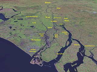
The Rhine–Meuse–Scheldt delta is a river delta in the Netherlands formed by the confluence of the Rhine, the Meuse and the Scheldt rivers. In some cases, the Scheldt delta is considered a separate delta to the Rhine–Meuse delta. The result is a multitude of islands, branches and branch names, in which a waterway that appears to be one continuous stream may have numerous separate names for different sections, e.g. Rhine → Bijlands Kanaal → Pannerdens Kanaal → Nederrijn → Lek → Nieuwe Maas → Het Scheur → Nieuwe Waterweg. Since the Rhine contributes most of the water, the term "Rhine Delta" is commonly used, although this name is also used for the delta where the Alpine Rhine flows into Lake Constance. By some calculations, the Rhine–Meuse–Scheldt delta covers 25,347 km2 (9,787 sq mi), making it the largest in Europe.

Rozenburg is an island in the western Netherlands, in the province of South Holland. Rozenburg Island was formed centuries ago from several sand bars in the Meuse estuary. In 1568, construction started on the first set of dikes and in 1586 the land known as Roosenburgh was leased to Dirk Ariensz. Bisdommer and Son, the first permanent inhabitant of Rozenburg.

Stenen Baak is a now-deactivated lighthouse northeast of Oostvoorne, near to the town of Brielle, in the Dutch province of South Holland. In several nautical sources of the 19th Century it is also referred to as Stone Beacon or Stone Baak. It protected the entrance to the Brielle harbour, a safe haven protecting ships from the tides and waters of the North Sea. The harbour is formed by the island of Voorne-Putten and the Brielse Meer and the rivers Oude Maas, Spui and Haringvliet. Brielle received city rights in 1306, developed the harbour during this time up until the fiefdom was added to Holland in 1371. The lighthouse itself was added in 1650. A fixed light during its time of operation, the lighthouse was visible in good weather up to a distance of four miles. It was deactivated in 1850.

The Voorne Canal is a former ship canal on Voorne-Putten in South Holland, the Netherlands. It was the first canal to connect Rotterdam to the sea. Construction of the canal started in 1826 and was completed in 1829. Until the completion of the Nieuwe Waterweg in 1872 it was the main connection from Rotterdam to the sea for ocean going ships.

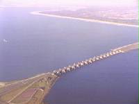
The Volkerakdam or Volkerakwerken is the name given to a group of hydraulic engineering structures located between Goeree-Overflakkee and North Brabant in The Netherlands. The works are not a single dam, but are composed of three distinct structures: a dam between Goeree-Overflakkee and Hellegatsplein, a series of locks from Hellegatsplein to North Brabant, and a bridge from Hellegatsplein to Hoekse Waard. The works cross three separate bodies of water: the Haringvliet, Hollands Diep and Volkerak. The works together comprise the fifth project of the Delta Works.

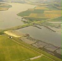
The Grevelingendam is a dam located in the Grevelingen sea inlet between Schouwen-Duiveland and Goeree-Overflakkee in The Netherlands. The Grevelingendam was the fourth structure constructed as part of the Delta Works.
The Zandkreekdam is a compartmentalisation dam located approximately 3 kilometres north of the city of Goes in The Netherlands, which connects Zuid-Beveland with Noord-Beveland, and separates the Oosterschelde from the Veerse Meer.

