Related Research Articles
Syracuse is a city and the county seat of Onondaga County, New York, United States. It is the fifth-most populated city and 13th-most populated municipality in the state of New York.

Fayetteville is a village located in Onondaga County, New York, United States. As of the 2020 U.S. Census, the population was 4,225. The village is named after the Marquis de Lafayette, a national hero of both France and the United States. It is part of the Syracuse Metropolitan Statistical Area.

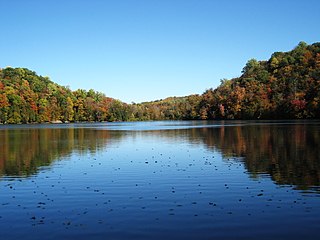
Liverpool is a lakeside village in Onondaga County, New York, United States. As of the 2020 census, the population was 2,242. The name was adopted from the city of Liverpool in the United Kingdom. The village is on Onondaga Lake, in the western part of the town of Salina and is northwest of Syracuse, of which it is a suburb.

Salina is a town in Onondaga County, New York, United States. As of the 2020 Census, the population was 33,223. The name of the town is derived from the Latin word for "salt." Salina is a northern suburb of Syracuse.

Solvay is a village located in the town of Geddes, Onondaga County, New York, United States, and a suburb of the city of Syracuse. As of the 2020 census, the population was 6,645. The village is named after the Solvay brothers, Belgian inventors of the chemical process employed by the Solvay Process Company, formerly the major industry of the village.

Armory Square is a small neighborhood on the west side of Downtown Syracuse, New York. It began life as a busy commercial and industrial area just to the west of the central city. After World War II, Syracuse's central city became less and less populated as more housing and business facilities were built in the suburbs. In the 1980s, plans were first made to transform the languishing district into a small shopping/arts/nightlife district surrounding the former Syracuse Armory. These plans came to fruition during the 1990s, when new stores and restaurants opened, and several new buildings were constructed in a compatible style to the middle and late 1800s and early 1900s architecture dominating the district.
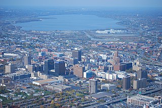
Downtown Syracuse is the economic center of Syracuse, New York, and Central New York, employing over 30,000 people, and housing over 4,300.

Starr Park is the name applied to several former sports stadiums in Syracuse, New York. The name referred to the Syracuse professional baseball teams, which were called the Stars beginning around 1870 and continuing in most seasons until the last Stars team was fielded in 1929.

Meadowbrook is a Syracuse, New York neighborhood, located in the southeastern corner of the city. It corresponds to Onondaga County Census Tract 46. It is named after Meadow Brook, which runs through it and into Butternut Creek.

The North Valley is a neighborhood in Syracuse, New York. The main streets include Midland Avenue, South Salina Street and Valley Drive. There are several neighborhood civic and athletic associations that extend into the South Valley neighborhood, as well as a thriving business community. Van Duyn Elementary School, and Faith Heritage are located within the North Valley.

Westside is a Syracuse, New York neighborhood, directly west of Downtown Syracuse. It corresponds to Onondaga County Census Tracts 21 and 22. It is made up of three parts, near West side, far west side and the West side

Near Northeast is a Syracuse, New York neighborhood, located northeast of the city's downtown. It corresponds to Onondaga County Census Tract 15, 16, 23, and 24.

The Gridley Building, built in 1867 and known previously as the Onondaga County Savings Bank Building, is a prominent historic building on Clinton Square and Hanover Square in Syracuse, New York, United States. It was designed by Horatio Nelson White and was built adjacent to what was then the Erie Canal and is now Erie Boulevard.

Salt Springs is a Syracuse, New York neighborhood, located in the northeastern corner of the city. It corresponds to Onondaga County Census Tract xx.
Elmwood is one of the 26 officially recognized neighborhoods of Syracuse, New York. It borders three other Syracuse neighborhoods, with Strathmore to the north, Brighton to the east, and North Valley to the south.
South Valley is a neighborhood on the South side of Syracuse, New York. It features Meachem Elementary School, Clary Middle School, Betts Branch library, Webster's Pond, and the Redmond family.

Washington Square is one of the 26 officially recognized neighborhoods of Syracuse, New York.
The National Register of Historic Places listings in Syracuse, New York are described below. There are 116 listed properties and districts in the city of Syracuse, including 19 business or public buildings, 13 historic districts, 6 churches, four school or university buildings, three parks, six apartment buildings, and 43 houses. Twenty-nine of the listed houses were designed by architect Ward Wellington Ward; 25 of these were listed as a group in 1996.
University Hill is a neighborhood and business district in Syracuse, New York, located east and southeast of Downtown Syracuse, on one of the larger hills in Syracuse. The neighborhood is bounded on the west by Almond Street and Interstate 81. It continues east to Ostrom Avenue and Thornden Park, where it borders the Westcott and University neighborhoods. Interstate 690 currently serves as the neighborhood's northern boundary.

The Onondaga Creekwalk is a mostly paved, partly bricked, multi-use trail running 4.8 miles (7.7 km) in Syracuse, New York, which has so far seen more than three decades of planning, construction, and delays, starting in 1988. The trail is designed for bicyclists, skaters, and pedestrians to approximately parallel any desired portion of Onondaga Creek's run connecting Kirk Park on Syracuse's South Side, downstream through downtown at Armory Square, and then on to Onondaga Lake at the creek's ultimate mouth.
References
- 1 2 Syracuse Housing Plan (PDF) (Report). City of Syracuse. 2010. pp. 104–106. Retrieved December 12, 2010.
- ↑ Parsons, Sarah (February 2008). "Sewage on the Southside: Not in my backyard". Plenty . Retrieved December 12, 2010.
- ↑ Carty, Linda (April 2007). "The Dirty Saga of Onondaga County". Ms. Archived from the original on December 5, 2010. Retrieved December 12, 2010.
- ↑ Beckwith, Maggie (April 15, 2004). "Law students file complaint, challenges Midland sewage plan". The Daily Orange . Archived from the original on September 27, 2011.
- ↑ Knauss, Tim (January 18, 2010). "Activists' persistence on sewage pushed Onondaga County to 'go green'". The Post-Standard . Retrieved December 12, 2010.
- ↑ "Events in City's History 1848-1897". Syracuse Herald . Syracuse, New York. October 10, 1897.
- ↑ Smith, Edward (1893). A history of the schools of Syracuse from its early settlement to January 1, 1893. Syracuse, New York: C.W. Bardeen. p. 34. LCCN 06015975.
- ↑ "National Register Information System". National Register of Historic Places . National Park Service. July 9, 2010.

43°1′17″N76°9′5″W / 43.02139°N 76.15139°W
| | This article about a location in Onondaga County, New York is a stub. You can help Wikipedia by expanding it. |