Brightwell Barrow

Last updated
View of Brightwell Barrow from the Wittenham Clumps side Brightwell Barrow from the clumps side - geograph.org.uk - 1751063.jpg
View of Brightwell Barrow from the Wittenham Clumps side

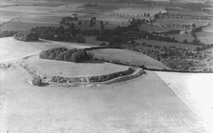
Brightwell Barrow is a Bronze Age round barrow in the civil parish of Brightwell-cum-Sotwell in the English county of Oxfordshire [1] (formerly Berkshire).

Bronze Age Prehistoric period and age studied in archaeology, part of the Holocene Epoch

The Bronze Age is a historical period characterized by the use of bronze, and in some areas proto-writing, and other early features of urban civilization. The Bronze Age is the second principal period of the three-age Stone-Bronze-Iron system, as proposed in modern times by Christian Jürgensen Thomsen, for classifying and studying ancient societies.

Round barrow Hemispherical mound of earth and/or stone raised over a burial placed in the middle

A round barrow is a type of tumulus and is one of the most common types of archaeological monuments. Although concentrated in Europe, they are found in many parts of the world, probably because of their simple construction and universal purpose.

Civil parish territorial designation and lowest tier of local government in England, UK

In England, a civil parish is a type of administrative parish used for local government, they are a territorial designation which is the lowest tier of local government below districts and counties, or their combined form, the unitary authority. Civil parishes can trace their origin to the ancient system of ecclesiastical parishes which historically played a role in both civil and ecclesiastical administration; civil and religious parishes were formally split into two types in the 19th century and are now entirely separate. The unit was devised and rolled out across England in the 1860s.

It lies just under a kilometre from Wittenham Clumps. Its position is marked by a small clump of trees on its peak. Brightwell Barrow is mentioned in the Domesday Book under the entry for Brightwell-cum-Sotwell.

Wittenham Clumps mountains in the United Kingdom

Wittenham Clumps is the common name for a pair of wooded chalk hills in the Thames Valley, in the civil parish of Little Wittenham, in the historic county of Berkshire, although since 1974 administered as part of South Oxfordshire district.

Domesday Book 11th-century survey of landholding in England as well as the surviving manuscripts of the survey

Domesday Book is a manuscript record of the "Great Survey" of much of England and parts of Wales completed in 1086 by order of King William the Conqueror. The Anglo-Saxon Chronicle states:

Then, at the midwinter [1085], was the king in Gloucester with his council .... After this had the king a large meeting, and very deep consultation with his council, about this land; how it was occupied, and by what sort of men. Then sent he his men over all England into each shire; commissioning them to find out "How many hundreds of hides were in the shire, what land the king himself had, and what stock upon the land; or, what dues he ought to have by the year from the shire."

Brightwell-cum-Sotwell village and civil parish in South Oxfordshire, England

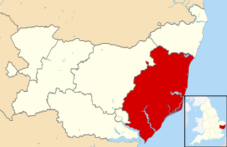
Brightwell-cum-Sotwell is a twin-village and civil parish in the Upper Thames Valley in South Oxfordshire. It lies between Didcot to the west and the historic market town of Wallingford to the east. In 1974 it was transferred from Berkshire to the county of Oxfordshire, and from Wallingford Rural District to the district of South Oxfordshire.

Related Research Articles

Suffolk Coastal Non-metropolitan district in England

Suffolk Coastal is a local government district in Suffolk, England. Its council is based in Melton, having moved from neighbouring Woodbridge in 2017. Other towns include Felixstowe, Framlingham, Leiston, Aldeburgh, and Saxmundham.

Merthyr Mawr village in the United Kingdom

Merthyr Mawr is a village and community in Bridgend, Wales. The village is about 2½ miles from the centre of Bridgend town. The population of the community at the 2011 census was 267. The community occupies the area west of the Ewenny River, between Bridgend and Porthcawl. It takes in the settlement of Tythegston and a stretch of coastal sand dunes known as Merthyr Mawr Warren.

Brandsby-cum-Stearsby

Brandsby-cum-Stearsby is a civil parish in the Hambleton district of North Yorkshire, England, with a population of 234, increasing to 383 at the 2011 Census and including Dalby-cum-Skewsby and Yearsley. It includes the villages of Brandsby and Stearsby.

Headington was a rural district in Oxfordshire, England from 1894 to 1932, based on the Headington rural sanitary district. It covered an area to the east of the city of Oxford. The parish of Headington was split out as a separate urban district in 1927.

Seven Barrows Bronze Age cemetery

Seven Barrows, situated just North of Lambourn, Berkshire, England, is a site of a Bronze Age cemetery. The cemetery is scheduled under the Ancient Monuments and Archaeological Areas Act 1979. The site is also a designated Site of Special Scientific Interest (SSSI).

Brightwell Castle was in the village of Brightwell-cum-Sotwell, between the towns of Didcot and Wallingford, now in Oxfordshire but until 1974 in Berkshire, in England.

Guildford College Further education establishment in the United Kingdom

Guildford College of Further and Higher Education (GCFHE) in Guildford, Surrey is a Surrey County Council-funded educational establishment for students of age 16+ undertaking full-time and part-time studies, established in 1939. Its original campus is signposted and known as Guildford College. GCFHE has expanded by incorporating two colleges to the north-west and 6 miles (9.7 km) to the west in Surrey.

Wallingford Rural District, an administrative area in what was then Berkshire, now Oxfordshire area, in southern England was established in 1894, from the then Berkshire area within Wallingford Rural Sanitary Authority. Wallingford Rural District Council provided many local government functions for the area around the town of Wallingford including Didcot, but not for the borough of Wallingford, which was covered by Wallingford Borough Council. These functions included dealing with contagious diseases, and wartime evacuations and air raid precautions. It also covered housing, water supply and sewage, and fire brigades. The parishes included were Aston Tirrold, Aston Upthorpe, Brightwell-cum-Sotwell, Cholsey, Didcot, East Hagbourne, Little Wittenham, Long Wittenham, Moulsford, North Moreton, South Moreton and West Hagbourne. In 1974 it became part of the district of South Oxfordshire, administered by South Oxfordshire District Council.

Sir Michael Molyns was a 16th century English politician.

The Venerable Archdeacon Alfred Pott (1822–1908) was an English churchman, Archdeacon of Berkshire from 1870 until 1903.

Edward Hyde (1607–1659) was an English royalist cleric, nominally Dean of Windsor at the end of his life.

Herbert Arthur Walton was an Anglican priest in the twentieth century.

Lodge Hill, Buckinghamshire

Lodge Hill is a 31.8 hectare Site of Special Scientific Interest north of Bledlow Ridge in Buckinghamshire. The local planning authorities are Wycombe District Council and Buckinghamshire County Council. The site is in the Chilterns Area of Outstanding Natural Beauty, and The Ridgeway long distance footpath crosses it.

Barrow Clump Archaeological site in Wiltshire

Barrow Clump is an archaeological site in Figheldean parish, Wiltshire, England, about 3 12 miles (5.6 km) north of the town of Amesbury. The site is a scheduled monument.

References

  1. Oxford, Chipping Norton and Bicester (Landranger Maps) (D1 ed.), Ordnance Survey, 2006, ISBN   978-0-319-22913-2

Coordinates: 51°37′23″N1°10′08″W / 51.623°N 1.169°W / 51.623; -1.169

Geographic coordinate system Coordinate system

A geographic coordinate system is a coordinate system that enables every location on Earth to be specified by a set of numbers, letters or symbols. The coordinates are often chosen such that one of the numbers represents a vertical position and two or three of the numbers represent a horizontal position; alternatively, a geographic position may be expressed in a combined three-dimensional Cartesian vector. A common choice of coordinates is latitude, longitude and elevation. To specify a location on a plane requires a map projection.