In physical geography, a fjord or fiord is a long, narrow sea inlet with steep sides or cliffs, created by a glacier. Fjords exist on the coasts of Antarctica, the Arctic, and surrounding landmasses of the northern and southern hemispheres. Norway's coastline is estimated to be 29,000 km (18,000 mi) long with its nearly 1,200 fjords, but only 2,500 km (1,600 mi) long excluding the fjords.

Stryn is a municipality in the county of Vestland, Norway. It is located in the traditional district of Nordfjord. The administrative center of the municipality is the village of Stryn. The municipality is located along the innermost part of the Nordfjorden. Some of the main villages in Stryn include Loen, Innvik, Utvik, Randabygda, Olden, and Flo.

A jökulhlaup is a type of glacial outburst flood. It is an Icelandic term that has been adopted in glaciological terminology in many languages. It originally referred to the well-known subglacial outburst floods from Vatnajökull, Iceland, which are triggered by geothermal heating and occasionally by a volcanic subglacial eruption, but it is now used to describe any large and abrupt release of water from a subglacial or proglacial lake/reservoir.

Jostedal Glacier or Jostedalsbreen (Norwegian) is the largest glacier in continental Europe. It is in Vestland county in Western Norway. Jostedalsbreen lies in the municipalities of Luster, Sogndal, Sunnfjord, and Stryn. The highest peak in the area is Lodalskåpa at a height of 2,083 metres (6,834 ft).

Nordfjord is a traditional district of Norway.

Jostedalsbreen National Park is a national park in Norway that encompasses the largest glacier on the European mainland, Jostedalsbreen. The park was established by royal decree on 25 October 1991, and then in 1998, it was enlarged to the northwest. The park now covers 1,310 square kilometres (510 sq mi), with the glaciers covering about 800 square kilometres (310 sq mi) of the park.

A terminal moraine, also called an end moraine, is a type of moraine that forms at the terminal (edge) of a glacier, marking its maximum advance. At this point, debris that has accumulated by plucking and abrasion, has been pushed by the front edge of the ice, is driven no further and instead is deposited in an unsorted pile of sediment. Because the glacier acts very much like a conveyor belt, the longer it stays in one place, the greater the amount of material that will be deposited. The moraine is left as the marking point of the terminal extent of the ice.
Svartisen is a collective term for two glaciers located in Nordland county in northern Norway. It is part of Saltfjellet-Svartisen National Park, located in the Saltfjell mountain range. The glaciers are located in the municipalities of Beiarn, Meløy, Rana, and Rødøy. Svartisen consists of two separate glaciers that are separated by the 1-kilometre (0.62 mi) long Vesterdalen valley. The two glaciers are:

Myklebustbreen or Snønipbreen is the seventh largest glacier in mainland Norway. It is located in the municipalities of Nordfjord, Gloppen, and Stryn in Vestland county. Its highest point is located just below the nunatak Snønipa, with an altitude of 1,827 metres (5,994 ft). The lowest point on the glacier is at an elevation of 890 metres (2,920 ft) above sea level.

The retreat of glaciers since 1850 is a well-documented effect of climate change. The retreat of mountain glaciers provide evidence for the rise in global temperatures since the late 19th century. Examples include mountain glaciers in western North America, Asia, the Alps in central Europe, and tropical and subtropical regions of South America and Africa. Since glacial mass is affected by long-term climatic changes, e.g. precipitation, mean temperature, and cloud cover, glacial mass changes are one of the most sensitive indicators of climate change. The retreat of glaciers is also a major reason for sea level rise. Excluding peripheral glaciers of ice sheets, the total cumulated global glacial losses over the 26 years from 1993 to 2018 were likely 5500 gigatons, or 210 gigatons per year.

Oppstrynsvatn is a lake in the municipality of Stryn in Vestland county, Norway. It is located about 8 kilometres (5.0 mi) east of the village of Stryn. The villages of Flo, Oppstryn, and Erdal are located on the shores of the lake.

Loen is a village in Stryn Municipality in Vestland county, Norway. It is located in the inner part of the Nordfjord region, at the easternmost end of the Nordfjorden. Loen is located about 6 kilometres (3.7 mi) north of the village of Olden and about 11 kilometres (6.8 mi) southeast of the municipal center of Stryn. The lake Lovatnet is located just to the southeast of the village of Loen. The Hotel Alexandra was established in Loen in 1884. The historic Loen Church is also located in the village.

Lovatnet is a lake in the municipality of Stryn in Vestland county, Norway. It is located about 2 kilometres (1.2 mi) southeast of the village of Loen and about 6 kilometres (3.7 mi) east of the village of Olden. The lake lies just 2 kilometres (1.2 mi) southwest of the mountain Skåla. The water from the lake flows down from the mountains; especially from the Jostedalsbreen and Tindefjellbreen glaciers. It then flows out through the Loelva river into the Nordfjorden.
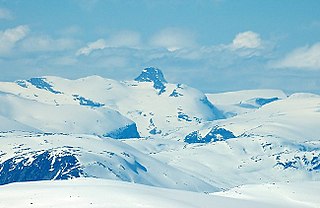
Lodalskåpa is the highest nunatak on the Norwegian glacier Jostedalsbreen. It is located on the border between the municipalities of Stryn and Luster in Vestland county, Norway, within Jostedalsbreen National Park.

Jostedalsbreen nasjonalparksenter is a visitors center in the village of Oppstryn in the municipality of Stryn in Vestland county, Norway. The center is east of the villages of Loen and Olden, on the shore of the lake Oppstrynsvatn. The mountain Skåla and the glaciers Briksdalsbreen and Jostedalsbreen are to the southwest of this visitor center.

Styggevatnet is a glacial lake from the glacier Jostedalsbreen in Luster Municipality in Vestland county, Norway. The lake lies just southeast of the lake Austdalsvatnet. The lake is regulated by a dam and it empties into the river Jostedøla. The lake is about 10 kilometres (6.2 mi) to the east of Lodalskåpa and Brenibba in Jostedalsbreen National Park.

Overdeepening is a characteristic of basins and valleys eroded by glaciers. An overdeepened valley profile is often eroded to depths which are hundreds of metres below the lowest continuous surface line along a valley or watercourse. This phenomenon is observed under modern day glaciers, in salt-water fjords and fresh-water lakes remaining after glaciers melt, as well as in tunnel valleys which are partially or totally filled with sediment. When the channel produced by a glacier is filled with debris, the subsurface geomorphic structure is found to be erosionally cut into bedrock and subsequently filled by sediments. These overdeepened cuts into bedrock structures can reach a depth of several hundred metres below the valley floor.

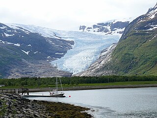
Oldedalen is a river valley in Stryn Municipality in Vestland county, Norway. The 20-kilometre (12 mi) long valley runs north-south and ends at the Nordfjorden at the village of Olden. The south end of the valley reaches up to the great Jostedalsbreen glacier inside Jostedalsbreen National Park. The small Briksdalsbreen is a smaller arm that branches off the main Jostedalsbreen glacier, and it sits at the end of the Oldedalen valley. It is a tourist attraction due to its easy to reach location. The western side of the valley is a fairly steep wall of mountains with the Myklebustbreen glacier at the top.
Jostedalen is a river valley in Luster Municipality in Vestland county, Norway. The 60-kilometre (37 mi) long valley runs from the Lustrafjorden at the village of Gaupne, to the north along the river Jostedøla and along the eastern side of the Jostedal Glacier. The valley is deep, but the valley floor lies over long stretches of flat river plains interrupted by steep steps. In the north, the landscape gets pretty wild. The Jostedalsbreen National Park surrounds the valley, which brings a lot of tourism to the area. The Nigardsbreen glacier is also accessible from the valley.