The Great Salt Lake is the largest saltwater lake in the Western Hemisphere and the eighth-largest terminal lake in the world. It lies in the northern part of the U.S. state of Utah and has a substantial impact upon the local climate, particularly through lake-effect snow. It is a remnant of Lake Bonneville, a prehistoric body of water that covered much of western Utah.
In food processing, brining is treating food with brine or coarse salt which preserves and seasons the food while enhancing tenderness and flavor with additions such as herbs, spices, sugar, caramel or vinegar. Meat and fish are typically brined for less than twenty-four hours while vegetables, cheeses and fruit are brined in a much longer process known as pickling. Brining is similar to marination, except that a marinade usually includes a significant amount of acid, such as vinegar or citrus juice. Brining is also similar to curing, which usually involves significantly drying the food, and is done over a much longer time period.

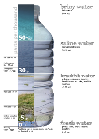
Brine is water with a high-concentration solution of salt. In diverse contexts, brine may refer to the salt solutions ranging from about 3.5% up to about 26%. Brine forms naturally due to evaporation of ground saline water but it is also generated in the mining of sodium chloride. Brine is used for food processing and cooking, for de-icing of roads and other structures, and in a number of technological processes. It is also a by-product of many industrial processes, such as desalination, so it requires wastewater treatment for proper disposal or further utilization.

A salt lake or saline lake is a landlocked body of water that has a concentration of salts and other dissolved minerals significantly higher than most lakes. In some cases, salt lakes have a higher concentration of salt than sea water; such lakes can also be termed hypersaline lakes, and may also be pink lakes on account of their colour. An alkalic salt lake that has a high content of carbonate is sometimes termed a soda lake.

Lake Magadi is the southernmost lake in the Kenyan Rift Valley, lying in a catchment of faulted volcanic rocks, north of Tanzania's Lake Natron. During the dry season, it is 80% covered by soda and is well known for its wading birds, including flamingos.

A salt evaporation pond is a shallow artificial salt pan designed to extract salts from sea water or other brines. The salt pans are shallow and expansive, allowing sunlight to penetrate and reach the seawater. Natural salt pans are formed through geologic processes, where evaporating water leaves behind salt deposits. Some salt evaporation ponds are only slightly modified from their natural version, such as the ponds on Great Inagua in the Bahamas, or the ponds in Jasiira, a few kilometres south of Mogadishu, where seawater is trapped and left to evaporate in the sun.

Saline water is water that contains a high concentration of dissolved salts. On the United States Geological Survey (USGS) salinity scale, saline water is saltier than brackish water, but less salty than brine. The salt concentration is usually expressed in parts per thousand and parts per million (ppm). The USGS salinity scale defines three levels of saline water. The salt concentration in slightly saline water is 1,000 to 3,000 ppm (0.1–0.3%); in moderately saline water is 3,000 to 10,000 ppm (0.3–1%); and in highly saline water is 10,000 to 35,000 ppm (1–3.5%). Seawater has a salinity of roughly 35,000 ppm, equivalent to 35 grams of salt per one liter of water. The saturation level is only nominally dependent on the temperature of the water. At 20 °C (68 °F) one liter of water can dissolve about 357 grams of salt, a concentration of 26.3 percent by weight. At 100 °C (212 °F), the amount of salt that can be dissolved in one liter of water increases to about 391 grams, a concentration of 28.1% w/w.

Lake Assal is a crater lake in central-western Djibouti. It is located at the western end of Gulf of Tadjoura between Arta Region, and Tadjoura Region, touching Dikhil Region, at the top of the Great Rift Valley, some 120 km (75 mi) west of Djibouti city. Lake Assal is a saline lake that lies 155 m (509 ft) below sea level in the Afar Triangle, making it the lowest point on land in Africa and the third-lowest point on Earth after the Sea of Galilee and the Dead Sea. No outflow occurs from the lake, and due to high evaporation, the salinity level of its waters is 10 times that of the sea, making it the fifth most saline body of water in the world, behind Garabogazköl, Lake Retba, and Gaet'ale Pond. The salt in the lake is exploited under four concessions awarded in 2002 at the southeast end of the lake; the major share of production is held by Société d’Exploitation du Lac and Société d’Exploitation du Salt Investment S.A de Djibouti.
A saline seep is seep of saline water, with an area of alkali salt crystals that form when the salty water reaches the surface and evaporates. Various types of water movement form saline seeps, including capillary action from a water table under the surface, and a water table being brought to the surface in a flow.

A sabkha is a coastal, supratidal mudflat or sandflat in which evaporite-saline minerals accumulate as the result of semiarid to arid climate. Sabkhas are gradational between land and intertidal zone within restricted coastal plains just above normal high-tide level. Within a sabkha, evaporite-saline minerals sediments typically accumulate below the surface of mudflats or sandflats. Evaporite-saline minerals, tidal-flood, and aeolian deposits characterize many sabkhas found along modern coastlines. The accepted type locality for a sabkha is at the southern coast of the Persian Gulf, in the United Arab Emirates. Evidence of clastic sabkhas are found in the geological record of many areas, including the UK and Ireland. Sabkha is a phonetic transliteration of the Arabic word used to describe any form of salt flat. A sabkha is also known as a sabkhah,sebkha, or coastal sabkha.

A brine pool, sometimes called an underwater lake, deepwater or brine lake, is a volume of brine collected in a seafloor depression. These pools are dense bodies of water that have a salinity that is typically three to eight times greater than the surrounding ocean. Brine pools are commonly found below polar sea ice and in the deep ocean. Those below sea ice form through a process called brine rejection. For deep-sea brine pools, salt is necessary to increase the salinity gradient. The salt can come from one of two processes: the dissolution of large salt deposits through salt tectonics or geothermally-heated brine issued from tectonic spreading centers.

A hypersaline lake is a landlocked body of water that contains significant concentrations of sodium chloride, brines, and other salts, with saline levels surpassing those of ocean water.
The Sülze Saltworks was a 'saline', or saltworks, on the Lüneburg Heath in Germany which was worked for centuries, from the High Middle Ages to 1862. It had a considerable impact on the history of the village of Sülze and other heath villages in the area.

The Wych Brook, Worthenbury Brook and Red Brook, formerly known as the River Elfe, is a tributary of the River Dee in England and Wales, forming part of both the historic and present-day border between the two countries. The stream forms part of the border between Cheshire and Shropshire in England to the east, and Wales, particularly the Maelor Saesneg, to the west.

The Technical Hallors and Saline Museum was founded in the buildings of the former Royal Prussian Saline, Halle upon Saale in 1967. Hallors had been members of a brotherhood of salt producers.

A brinicle is a downward-growing hollow tube of ice enclosing a plume of descending brine that is formed beneath developing sea ice.

An inland salt marsh is a saltwater marsh located away from the coast. It is formed and maintained in areas when evapotranspiration exceeds precipitation and/or when sodium- and chloride-laden groundwater is released from natural brine aquifers. Its vegetation is dominated by halophytic plant communities.
Salt Springs is an unincorporated community in Saline County, in the U.S. state of Missouri.
Salt Pond Township is an inactive township in Saline County, in the U.S. state of Missouri.

The Saline Valley salt tram is located in Inyo County, California, United States. The electric aerial tramway was constructed from 1911 to 1913 to carry salt from the Saline Valley over the Inyo Mountains and into the Owens Valley. Covering a distance of 13.4 mi (21.6 km), it operated sporadically from 1913 to 1935 for four different companies. During its operation, it was the steepest tram in the United States.


