
The Great Dividing Range, or the Eastern Highlands, is Australia's most substantial mountain range and the fifth longest land-based range in the world. It stretches more than 3,500 kilometres (2,175 mi) from Dauan Island in the Torres Strait off the northern tip of Cape York Peninsula, Queensland, running the entire length of the eastern coastline through New South Wales, then into Victoria and turning west, before finally fading into the central plain at the Grampians in western Victoria.

Queensland is a state of Australia. It is the second-largest and third-most populous Australian state. It is a federated state and a parliamentary constitutional monarchy. Situated in the north-east of the country, it is bordered by the Northern Territory, South Australia and New South Wales to the west, south-west and south respectively. To the east, Queensland is bordered by the Coral Sea and Pacific Ocean. To its north is the Torres Strait, separating the Australian mainland from Papua New Guinea. With an area of 1,852,642 square kilometres (715,309 sq mi), Queensland is the world's sixth-largest sub-national entity, and is larger than all but 15 countries. Due to its size, Queensland's geographical features and climates are diverse, including tropical rainforests, rivers, coral reefs, mountain ranges and sandy beaches in its tropical and sub-tropical coastal regions, as well as deserts and savanna in the semi-arid and desert climactic regions of its interior.

Expedition is a national park in Queensland, Australia, 490 km northwest of Brisbane. It is named for the Expedition Range of mountains.

The Main Range is a mountain range and national park in Queensland, Australia, located predominantly in Tregony, Southern Downs Region, 85 kilometres (53 mi) southwest of Brisbane. It is part of the World Heritage Site Gondwana Rainforests of Australia. It protects the western part of a semicircle of mountains in South East Queensland known as the Scenic Rim. This includes the largest area of rainforest in South East Queensland. The park is part of the Scenic Rim Important Bird Area, identified as such by BirdLife International because of its importance in the conservation of several species of threatened birds.

Brisbane is the capital of and the most populous city in the Australian state of Queensland, and the third most populous city in Australia. Brisbane's metropolitan area has a population of over 2.5 million, and the South East Queensland metropolitan region, centred on Brisbane, encompasses a population of more than 3.6 million. The Brisbane central business district stands on the historic European settlement and is situated inside a peninsula of the Brisbane River, about 15 kilometres from its mouth at Moreton Bay, a bay of the Coral Sea. The metropolitan area extends in all directions along the hilly floodplain of the Brisbane River Valley between Moreton Bay and the Taylor and D'Aguilar mountain ranges. It sprawls across several of Australia's most populous local government areas (LGAs)—most centrally the City of Brisbane, which is by far the most populous LGA in the nation. The demonym of Brisbane is "Brisbanite", whilst common nicknames include "Brissy", "River City" and "Brisvegas".

The McPherson Range is an extensive mountain range, a spur of the Great Dividing Range, heading in an easterly direction from near Wallangarra to the Pacific Ocean coastline. It forms part of the Scenic Rim on the border between the states of New South Wales and Queensland. Further west of the McPherson Range is the Main Range. Towards the coast the range continues into the Border Ranges and other mountainous terrain formed by the Tweed Volcano.

Mount Lindesay is a rural locality in the Scenic Rim Region, Queensland, Australia. It borders New South Wales. In the 2016 census, Mount Lindesay had a population of 3 people.

South East Queensland (SEQ) is a bio-geographical, political, and administrative region of the state of Queensland in Australia, which contains more than 3.6 million people out of the state's population of 5.1 million. The area covered by South East Queensland varies, depending on the definition of the region, though it tends to include Queensland's three largest cities: the capital city Brisbane; the Gold Coast; and the Sunshine Coast. Its most common use is for political purposes, and covers 22,420 square kilometres (8,660 sq mi) and incorporates 11 local government areas, extending 240 kilometres (150 mi) from Noosa in the north to the Gold Coast and New South Wales border in the south, and 140 kilometres (87 mi) west to Toowoomba.

The Spirit of the Outback is a long-distance passenger rail service in Queensland, Australia, operated by Queensland Rail's Traveltrain division.

Mount Coot-tha is a mountain and a suburb of the City of Brisbane, Queensland, Australia. In the 2016 census, there were no residents in the suburb.
The D'Aguilar Range is a mountain range near Brisbane, Queensland, Australia. The town of Dayboro is situated on the lower foothills midway along the range and the Sunshine Coast Hinterland town of Mooloolah lies at the northernmost point of the range. Many residential areas line its eastern slopes including the town of Samford and the suburb of Ferny Hills. In the west, numerous ridges and gullies are heavily forested and designated as state forest or national park.

Mount Glorious is a rural locality in the Moreton Bay Region, Queensland, Australia. In the 2016 census, Mount Glorious had a population of 296 people.
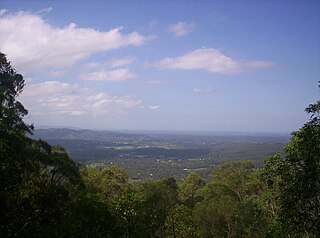
The Scenic Rim is a group of forested mountain ranges of the Great Dividing Range, located south of Brisbane agglomeration, straddling the border between south-eastern Queensland and north-eastern New South Wales, Australia.

The Glass House Mountains are a cluster of thirteen hills that rise abruptly from the coastal plain on the Sunshine Coast, Queensland, Australia. The highest hill is Mount Beerwah at 556 metres above sea level, but the most identifiable of all the hills is Mount Tibrogargan which from certain angles bears a resemblance to a face staring east towards the ocean. The Glass House Mountains are located near Beerburrum State Forest and Steve Irwin Way. From Brisbane, the mountains can be reached by following the Bruce Highway north and taking the Glass House Mountains tourist drive turn-off onto Steve Irwin Way. The trip is about one hour from Brisbane. The Volcanic peaks of the Glass House Mountains rise dramatically from the surrounding Sunshine Coast landscape. They were formed by intrusive plugs, remnants of volcanic activity that occurred 26-27 million years ago. Molten rock filled small vents or intruded as bodies beneath the surface and solidified into land rocks. Millions of years of erosion have removed the surrounding exteriors of volcanic cores and softer sandstone rock.
The Blackall Range is a mountain range in South East Queensland, Australia. The first European explorer in the area was Ludwig Leichhardt. It was named after Samuel Blackall, the second Governor of Queensland.

The Conondale Range is a mountain range in Queensland, located between Maleny, Kenilworth, Kilcoy and Jimna. The range is the most westerly part of the Sunshine Coast hinterland and part of the Great Dividing Range. The highest point on the range is Mount Langley reaching 868 m above sea level. This is also the highest point in the Brisbane River catchment.

The Little Liverpool Range is a mountain range of the Scenic Rim and Lockyer Creek valley, part of the Great Dividing Range, which is located in the South East region of Queensland, Australia.

The Flinders Peak Group is an unnamed mountain range located on the northern edge of the Scenic Rim Region, south west of Logan City and south east of the City of Ipswich in South East Queensland, Australia. The summit in the Range is Flinders Peak reaching 680 metres (2,230 ft) above sea level.
Mount Byron is a rural locality and a mountain in the Somerset Region, Queensland, Australia.

Mount Gipps is a locality in the Scenic Rim Region, Queensland, Australia. It borders New South Wales and is one end of the Queensland rabbit-proof fence.
