Bezděkov is a village in the Pardubice Region of the Czech Republic. It has cca 250 inhabitants.

Câlnic is a commune in Alba County, Romania, composed of two villages, Câlnic and Deal (Dál). Câlnic village is known for its castle, which is on UNESCO's list of World Heritage Sites.
North Waterford is a village in the town of Waterford in Oxford County, Maine.
Dębowa Góra is a village in the administrative district of Gmina Dzierżoniów, within Dzierżoniów County, Lower Silesian Voivodeship, in south-western Poland.

Goychay is a city and municipality in and the capital of the Goychay Rayon of Azerbaijan. The municipality includes the city of Goychay and the nearby village of Qızılqaya.

Begal Urdu: بیگال is a village and union council, an administrative subdivision, of Chakwal District in the Punjab Province of Pakistan, it is part of Chakwal Tehsil and is located at 33°2'57N 72°39'11E.
The canton of Barcelonnette is an administrative division in southeastern France. At the French canton reorganisation which came into effect in March 2015, the canton was expanded from 11 to 16 communes :

Semyonovka, is a village in the Gegharkunik Province of Armenia. It was founded in 1845 by Spiritual Christian settlers,, who escaped oppression in Russia.

Nowy Bedoń is a village in the administrative district of Gmina Andrespol, within Łódź East County, Łódź Voivodeship, in central Poland. It lies approximately 2 kilometres (1 mi) north-east of Andrespol and 14 km (9 mi) south-east of the regional capital Łódź.
Winna is a village in the administrative district of Gmina Łagów, within Kielce County, Świętokrzyskie Voivodeship, in south-central Poland. It lies approximately 4 kilometres (2 mi) east of Łagów and 39 km (24 mi) east of the regional capital Kielce.
Potok is a village in the administrative district of Gmina Ożarów, within Opatów County, Świętokrzyskie Voivodeship, in south-central Poland. It lies approximately 7 kilometres (4 mi) north of Ożarów, 23 km (14 mi) north-east of Opatów, and 74 km (46 mi) east of the regional capital Kielce.
Winiarki is a village in the administrative district of Gmina Dwikozy, within Sandomierz County, Świętokrzyskie Voivodeship, in south-central Poland. It lies approximately 5 kilometres (3 mi) north-east of Dwikozy, 11 km (7 mi) north-east of Sandomierz, and 86 km (53 mi) east of the regional capital Kielce.
Tymoteuszew is a village in the administrative district of Gmina Jakubów, within Mińsk County, Masovian Voivodeship, in east-central Poland. It lies approximately 10 kilometres (6 mi) north-east of Mińsk Mazowiecki and 45 km (28 mi) east of Warsaw.
Niestępowo Włościańskie is a village in the administrative district of Gmina Pokrzywnica, within Pułtusk County, Masovian Voivodeship, in east-central Poland.
Główczyn is a village in the administrative district of Gmina Szczytniki, within Kalisz County, Greater Poland Voivodeship, in west-central Poland.
Lichnowy is a village in the administrative district of Gmina Chojnice, within Chojnice County, Pomeranian Voivodeship, in northern Poland. It lies approximately 7 kilometres (4 mi) south-east of Chojnice and 104 km (65 mi) south-west of the regional capital Gdańsk.
Słajszewo is a village in the administrative district of Gmina Choczewo, within Wejherowo County, Pomeranian Voivodeship, in northern Poland. It lies approximately 8 kilometres (5 mi) north-west of Choczewo, 35 km (22 mi) north-west of Wejherowo, and 71 km (44 mi) north-west of the regional capital Gdańsk.

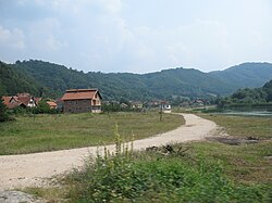
Dobro Polje is a village in the municipality of Boljevac, Serbia. According to the 2002 census, the village has a population of 415 people.
Soo-otsa is a village in Lääne-Nigula Parish, Lääne County, in western Estonia.

Trstena is a village in the municipality of Vranje, Serbia. According to the 2002 census, the village has a population of 63 people.