
Totteridge is a residential area and former village in the London Borough of Barnet, England. It is a mixture of suburban development and open land situated 8 miles (13 km) north north-west of Charing Cross. It is part of the Whetstone postal district (N20).
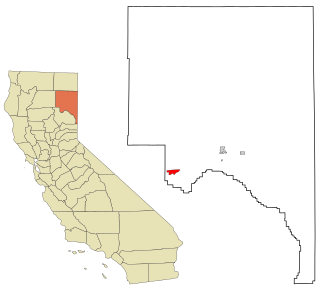
Westwood is a census-designated place (CDP) in Lassen County, California, United States. Westwood is located 20 miles (32 km) west-southwest of Susanville, at an elevation of 5,128 feet. Its population is 1,541 as of the 2020 census, down from 1,647 from the 2010 census..

Westwood Lakes is a census-designated place and unincorporated community of Miami-Dade County, Florida, United States. It is part of the Miami metropolitan area of South Florida. The population was 11,373 at the 2020 census.

Westwood is a city in northeast Johnson County, Kansas, United States. As of the 2020 census, the population of the city was 1,750. It is the second most densely populated city in the Kansas City Metropolitan Area.

Westwood is a town in Norfolk County, Massachusetts, United States. The population was 16,266 at the 2020 United States Census.

Excelsior is a city in Hennepin County, Minnesota, United States. Excelsior's historic commercial district along Water Street is listed on the National Register of Historic Places, and the town has many Victorian-era houses. On Lake Minnetonka's southern shore, the community serves as a local tourism destination for shoppers, boaters, and restaurant-goers.

North Saint Paul is a city in Ramsey County, Minnesota, United States, located east-northeast of the city of Saint Paul. The population was 12,364 at the 2020 census.

Walton Hills is a village in Cuyahoga County, Ohio, United States. The population was 2,033 at the 2020 census. A suburb of Cleveland, it is a part of the Cleveland metropolitan area.
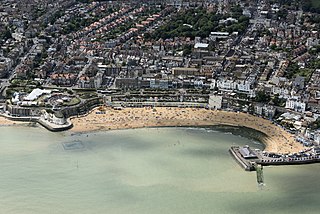
Broadstairs is a coastal town on the Isle of Thanet in the Thanet district of east Kent, England, about 80 miles (130 km) east of London. It is part of the civil parish of Broadstairs and St Peter's, which includes St Peter's, and had a population in 2011 of about 25,000. Situated between Margate and Ramsgate, Broadstairs is one of Thanet's seaside resorts, known as the "jewel in Thanet's crown". The town's coat of arms' Latin motto is Stella Maris. The name derives from a former flight of steps in the chalk cliff, which led from the sands up to the 11th-century shrine of St Mary on the cliff's summit.

Westgate-on-Sea is a seaside town and civil parish on the north-east coast of Kent, England. It is within the Thanet local government district and borders the larger seaside resort of Margate. Its two sandy beaches have remained a popular tourist attraction since the town's development in the 1860s from a small farming community. The town had a population of 7,517 at the 2021 Census.

Birchington-on-Sea is a village in the Thanet district in Kent, England, with a population of 9,961.

Ōkato is a small town in rural Taranaki, New Zealand. It is situated about 25 minutes drive around the coast from New Plymouth on State Highway 45. Ōakura is 12 km to the north-east, and Warea is 9 km to the south-west. The place offers popular rocky surfing spots around coastal beaches. The town was established as a military settlement in the 1860s.

Parham is a village and civil parish in the East Suffolk district of Suffolk in eastern England. Located seven miles north of Woodbridge, in 2005 it had a population of 300, reducing to 263 at the 2011 census and according to the 2011 census there were 129 males and 134 females living at this time.
Stanhope is a civil parish and suburb of Ashford in the Borough of Ashford in Kent, England. It was built in the 1960s on the southern edge of the town.
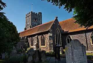
St Peter's is an area of Broadstairs, in the civil parish of Broadstairs and St Peter's, on the Isle of Thanet, in Kent, England. Historically a village, it was outgrown by the long-dominant settlement of the two, Broadstairs, after 1841. Originally the borough or manor of the church of St. Peter-in-Thanet, it was said to be the largest parish east of London, at least until Broadstairs became a separate parish on 27 September 1850. The two settlements were formally merged administratively in 1895.

Garlinge is a village and suburb of Margate, in the Thanet district, in Kent, England, situated 2 miles (3.2 km) southwest of the centre of the town.
Maromaku is a locality in the Northland Region of the North Island of New Zealand. Kawakawa is north, and Towai is southeast. State Highway 1 runs past Maromaku to the north, and the North Auckland Line runs through it.

Maheno is a small North Otago township south of Oamaru in New Zealand. The area has 75 residents. A number of the town's streets are named after places in Tyne and Wear, England, such as Whickham, Felling, Heworth and Jarrow. One of two New Zealand's hospital ships in World War I, the SS Maheno, was named after this town.
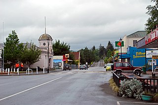
Wakefield is a settlement in the Tasman District of New Zealand's South Island, located about 25km south west of Nelson.
Poughill is a village and civil parish in the Mid Devon district, in the county of Devon, England. It lies 5 miles (8 km) north of Crediton. In 2011, the parish had a population of 216.

