
The Stone Arch Bridge is a former railroad bridge crossing the Mississippi River at Saint Anthony Falls in downtown Minneapolis, Minnesota. It is the only arched bridge made of stone on the entire Mississippi River. It is the second oldest bridge on the river next to Eads Bridge. The bridge was built to connect the railway system to the new Union Depot, which at that time was planned to be built between Hennepin Avenue and Nicollet Avenue. The bridge was completed in 1883, costing $650,000 at the time. 117 Portland Avenue is the general address of the historic complex.

The Morrison Bridge is a bascule bridge that spans the Willamette River in Portland, Oregon. Completed in 1958, it is the third bridge at approximately the same site to carry that name. It is one of the most heavily used bridges in Portland. It was added to the National Register of Historic Places in November 2012.

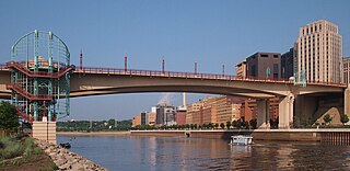
The Hennepin Avenue Bridge is the structure that carries Hennepin County State Aid Highway 52, Hennepin Avenue, across the Mississippi River in Minneapolis, Minnesota, at Nicollet Island. Officially, it is the Father Louis Hennepin Bridge, in honor of the 17th-century explorer Louis Hennepin, who was the first European to see the Saint Anthony Falls, a short distance downriver. It is the fourth bridge on the site.

The Third Avenue Bridge is a landmark structure of the city of Minneapolis, Minnesota, United States, originally known as the St. Anthony Falls Bridge. It carries road traffic across the Mississippi River and upper fringes of Saint Anthony Falls. The multi-arched bridge meets with Third Avenue in downtown Minneapolis at its south end, but curves as it crosses the river, and connects with Central Avenue on its north end. The shallow "S" curve in the bridge was built to avoid fractures in the limestone bedrock that supports the bridge piers. The road is also designated Minnesota State Highway 65. Construction began in 1914, and it opened four years later in 1918. The bridge, which uses Melan arches of an open spandrel design, has been modified since that time. The 2,223-foot crossing was designed by city engineer Frederick W. Cappelen, who also created plans for other similar bridges in Minneapolis such as the Franklin Avenue Bridge. It cost US$862,254.00 at the time of construction.

The 10th Avenue Bridge crosses the Mississippi River near downtown Minneapolis, Minnesota and also in proximity to the University of Minnesota. The bridge was historically referred to as the Cedar Avenue Bridge in the days prior to the construction of the I-35W Mississippi River bridge when it connected to Cedar Ave. The bridge connects 10th Avenue Southeast, on the east side of the Mississippi River, to 19th Avenue South on the west side. The Seven Corners area of the Cedar-Riverside, Minneapolis neighborhood is at the southern end of the bridge. The downstream end of the lower Saint Anthony Falls lock and dam extends under the bridge. The historic Southeast Steam Plant is also located nearby.
The North Channel Bridge crosses the north channel of the Mississippi River between Latsch Island and Buffalo County, Wisconsin.

The Smith Avenue High Bridge or the High Bridge is an inverted arch bridge that carries Minnesota State Highway 149 and Smith Avenue over the Mississippi River in Saint Paul, Minnesota, United States. It was built and opened in 1987 at a cost of $20 million. The bridge carries two lanes of street traffic over the river and is the highest bridge in St. Paul, with a deck height of 160 ft (49 m) and a clearance below of 149 ft (45 m).

The Burlington Bridge is a vertical-lift railroad bridge across the Mississippi River between Burlington, Iowa, and Gulfport, Illinois, United States. It is currently owned by BNSF Railway and carries two tracks which are part of BNSF's Chicago–Denver main line.

The Hot Metal Bridge is a truss bridge in Pittsburgh, Pennsylvania, that crosses the Monongahela River. The bridge consists of two parallel spans on a single set of piers: the former Monongahela Connecting Railroad Bridge, built in 1887, on the upstream side and the former Hot Metal Bridge, built in 1900, on the downstream side. The Monongahela Connecting Railroad Bridge carried conventional railroad traffic, while the Hot Metal Bridge connected parts of the J&L Steel mill, carrying crucibles of molten iron from the blast furnaces in ladle transfer cars to the open hearth furnaces on the opposite bank to be converted to steel. During World War II 15% of America's steel making capacity crossed over the Hot Metal Bridge, up to 180 tons per hour. The upstream span was converted to road use after a $14.6 million restoration, and opened by Mayor Tom Murphy with a ceremony honoring former steel workers on June 23, 2000. The bridge connects 2nd Avenue at the Pittsburgh Technology Center in South Oakland with Hot Metal Street in the South Side. The downstream span reopened for pedestrian and bicycle use in late 2007 after two years of work. The Great Allegheny Passage hiker/biker trail passes over this bridge as it approaches Pittsburgh's Golden Triangle area.
The Wabasha Street Bridge is a segmental bridge that spans the Mississippi River in downtown Saint Paul, Minnesota, United States. It was named Wabasha Street Freedom Bridge in 2002, to commemorate the first anniversary of the September 11 attacks. It actually consists of two separate bridges, one for northbound and one for southbound traffic. The use of a concrete segmental box girder bridge provided a construction advantage because no falsework needed to be built beneath the bridge.
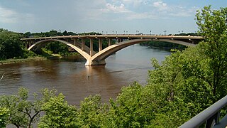
The Lake Street–Marshall Avenue Bridge is a reinforced concrete arch bridge that spans the Mississippi River between Minneapolis, Minnesota and St. Paul, Minnesota. It is oriented east-west and connects Lake Street in Minneapolis to Marshall Avenue in St. Paul. St. Paul residents often refer to it as the Marshall Avenue Bridge. The bridge was designed by Howard, Needles, Tammen, and Bergendoff.

Main Channel Bridge (Winona) consists of a pair of bridges, the original cantilever bridge, and a concrete box girder bridge completed in 2016, that span the main channel of the Mississippi River in the United States between Winona, Minnesota, and Latsch Island. Another bridge, the North Channel Bridge, connects the island to rural Buffalo County, Wisconsin. The bridge carries Minnesota State Highway 43, which continues as Wisconsin Highway 54 at the Minnesota/Wisconsin state line on the nearby North Channel Bridge; in Winona, it connects to Winona Street.

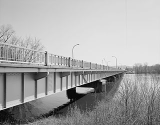
The Anoka–Champlin Mississippi River Bridge, also known as the Ferry Street Bridge, is a 10-span open spandrel concrete deck arch bridge that spans the Mississippi River between Anoka and Champlin, Minnesota, United States. It was built in 1929 by the Minneapolis Bridge Company, replacing an 1884 bridge at the same site.

Northern Pacific-BNSF Minneapolis Rail Bridge is a combination plate girder bridge and truss bridge that spans the Mississippi River in Minneapolis, Minnesota.

Merriam Street Bridge is a truss bridge that spans the east channel of the Mississippi River between Nicollet Island and the east bank of the river in Minneapolis. The bridge was originally built in 1887 by King Iron Bridge Company as one of the four spans of the Broadway Avenue Bridge. When the Broadway Avenue Bridge was reconstructed in 1987, one span was preserved and moved to Nicollet Island. The truss span is actually decorative; the bridge is supported by a beam from underneath.

The following are all the contributing resources to the Saint Anthony Falls Historic District in Minneapolis, Minnesota, United States. The District is listed on the National Register of Historic Places, thus these properties are on the NRHP. The "period of significance" of the District was 1858–1941. The district's archaeological record is considered to be one of the most-endangered historic sites in Minnesota.

The Ellsworth Street Bridge is a highway bridge that crosses the Willamette River in Albany, Oregon, United States. Built in 1925, the two-lane structure carries U.S. Route 20 eastbound traffic, with the adjacent Lyon Street Bridge carrying westbound traffic. The 1,090-foot-long (330 m) steel truss bridge was designed by Conde McCullough and opened in 1926.

The Dodd Ford Bridge is a bridge spanning the Blue Earth River about 1 mile (2 km) southwest of Amboy, Minnesota, in Blue Earth County, Minnesota.

The Holmes Street Bridge, also known the Holmes Street Pedestrian Bridge, Old Shakopee Bridge, or Bridge 4175, is a historic truss bridge over the Minnesota River in Shakopee, Minnesota, United States. It is one of the state's only examples of a deck truss bridge. It was constructed in 1927 with parts manufactured by the Minneapolis Steel & Machinery Company. The bridge formerly carried US 169 and MN 101, and served as the principal river crossing for Shakopee. The Holmes Street Bridge was closed to vehicular traffic in 2005. It was rehabilitated in 2011 to carry a trail for pedestrians, cross-country skiers, and snowmobiles.
The Winona Rail Bridge was a swing bridge that spanned the Mississippi River between Winona, Minnesota, and Winona Junction in Buffalo, Buffalo County, Wisconsin. It was built to link the Winona and St. Peter Railroad with the La Crosse, Trempealeau & Prescott Railroad. Both railroads became part of the Chicago and North Western Transportation Company (C&NW). Parts of the bridge are still visible. The swing span was removed, but the box girder portion of the bridge still extends from Latsch Island just downstream of the current Main Channel Bridge. Piers from the original 1871 bridge and the box girders are in the North Channel just downstream of the current North Channel Bridge.


