
Box Hill is a summit of the North Downs in Surrey, approximately 31 km (19 mi) south-west of London. The hill gets its name from the ancient box woodland found on the steepest west-facing chalk slopes overlooking the River Mole. The western part of the hill is owned and managed by the National Trust, whilst the village of Box Hill lies on higher ground to the east. The highest point is Betchworth Clump at 224 m (735 ft) above OD, although the Salomons Memorial overlooking the town of Dorking is the most popular viewpoint.

Surrey Wildlife Trust (SWT) was founded in 1959 as Surrey Naturalists' Trust and it is one of forty-six wildlife trusts covering Great Britain, Northern Ireland, Isle of Man and Alderney. SWT carries out conservation activities on a considerable area of Surrey County Council's large countryside estate and also manages land on behalf of the Ministry of Defence estate. As of 2022 the SWT manages more than 6,000 hectares of land for wildlife and employs more than 100 staff. It had an income of £5.1 million and expenditure of £5.7 million.

Brockham is a village and civil parish in the Mole Valley district of Surrey, England. It is approximately 1.5 miles (2.4 km) east of Dorking and 4 miles (6.4 km) west of Reigate. The village lies south of Box Hill, with the River Mole flowing west through the village. At the 2011 census, it had a population of 2,868.

Betchworth is a village and civil parish in the Mole Valley district of Surrey, England. The village centre is on the north bank of the River Mole and south of the A25 road, almost 3 miles (4.8 km) east of Dorking and 3 miles (4.8 km) west of Reigate. London is 19.5 miles (31.4 km) north of the village.

Totternhoe Stone is a relatively hard chalk outcropping in the middle of the Lower Chalk in the Chiltern Hills in Hertfordshire, Buckinghamshire, Bedfordshire and Cambridgeshire, England. Geologically, it is located in the upper part of the Cenomanian stage of the Cretaceous.

Norbury Park is an area of mixed wooded and agricultural land surrounding a privately owned its Georgian manor house near Leatherhead and Dorking, Surrey. On the west bank of the River Mole, it is close to the village of Mickleham.
Wye and Crundale Downs is a 358.3-hectare (885-acre) biological and geological Site of Special Scientific Interest in a number of separate areas east of Ashford in Kent. It is a Special Area of Conservation and a Nature Conservation Review site, Grade I. and it is part of Kent Downs Area of Outstanding Natural Beauty. Some areas are part of a National Nature Reserve, and another area is listed on the Geological Conservation Review.

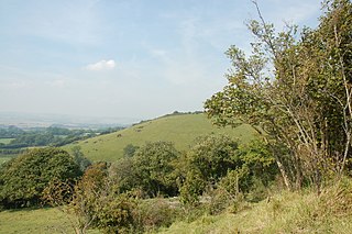
Mole Gap to Reigate Escarpment is a 1,016.4-hectare (2,512-acre) biological and geological Site of Special Scientific Interest west of Reigate in Surrey. It is a Geological Conservation Review site and a Special Area of Conservation. Part of it is a Nature Conservation Review site, Grade I. Two small private nature reserves in the site are managed by the Surrey Wildlife Trust, Dawcombe and Fraser Down.

Seale Chalk Pit is a 1.2-hectare (3.0-acre) geological Site of Special Scientific Interest west of Guildford in Surrey. It is a Geological Conservation Review site and part of the Seale Chalk Pit and Meadow 3-hectare (7.4-acre) private nature reserve, which is managed by the Surrey Wildlife Trust.
Southerham Works Pit is a 1-hectare (2.5-acre) geological Site of Special Scientific Interest in Lewes in East Sussex. It is a Geological Conservation Review site.

Colley Hill is part of the North Downs escarpment in the North Downs, Surrey, England. It is about 1 km east of Buckland Hills and 1 km west of Reigate Hill, all of which form part of the same escarpment. It is centred 30 kilometres (19 mi) south of London and forms a single scarp with Reigate Hill, peaking 2 miles (3 km) away at 235 metres above sea level. The scarp fluctuates in height but is continuous as far as Box Hill 5 miles (8 km) west. The term "Reigate Hill" also designates a neighbourhood of Reigate, and also a ward of Reigate and Banstead.

The Glen Chalk Caves, Bury St Edmunds is a 1.6-hectare (4.0-acre) biological Site of Special Scientific Interest in Bury St Edmunds in Suffolk.

Alderford Common is a 17.5-hectare (43-acre) biological Site of Special Scientific Interest north-west of Norwich in Norfolk.

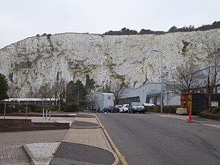
Betchworth Quarry and Lime Kilns is a 27-hectare (67-acre) nature reserve north of Betchworth in Surrey. Betchworth Quarry only is managed by Surrey Wildlife Trust. It is part of the Mole Gap to Reigate Escarpment Site of Special Scientific Interest and Special Area of Conservation.

Dawcombe is a 23-hectare (57-acre) nature reserve north-west of Reigate in Surrey. It is managed by the Surrey Wildlife Trust. It is part of the Mole Gap to Reigate Escarpment Site of Special Scientific Interest and Special Area of Conservation.

Fraser Down is a 10-hectare (25-acre) nature reserve north of Betchworth in Surrey. It is managed by the Surrey Wildlife Trust. It is part of the Mole Gap to Reigate Escarpment Site of Special Scientific Interest and Special Area of Conservation.
The Brockham Railway Museum was a 2 ft narrow gauge railway based at the site of the Brockham Limeworks, near Dorking, Surrey. When it closed in 1982, the majority of the collection was moved to the Amberley Museum & Heritage Centre where it formed the nucleus of the Amberley Museum Railway.

