Ochle is a village in the administrative district of Gmina Widawa, within Łask County, Łódź Voivodeship, in central Poland. It lies approximately 8 kilometres (5 mi) south of Widawa, 29 km (18 mi) south-west of Łask, and 60 km (37 mi) south-west of the regional capital Łódź.
Nałęczów is a village in the administrative district of Gmina Końskie, within Końskie County, Świętokrzyskie Voivodeship, in south-central Poland. It lies approximately 6 kilometres (4 mi) north-west of Końskie and 43 km (27 mi) north-west of the regional capital Kielce.
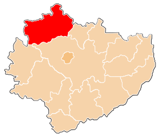
Nowy Dziebałtów is a village in the administrative district of Gmina Końskie, within Końskie County, Świętokrzyskie Voivodeship, in south-central Poland. It lies approximately 9 kilometres (6 mi) south-west of Końskie and 36 km (22 mi) north-west of the regional capital Kielce.
Nowy Sokołów is a village in the administrative district of Gmina Końskie, within Końskie County, Świętokrzyskie Voivodeship, in south-central Poland. It lies approximately 12 kilometres (7 mi) south-west of Końskie and 37 km (23 mi) north-west of the regional capital Kielce.
Stadnicka Wola is a village in the administrative district of Gmina Końskie, within Końskie County, Świętokrzyskie Voivodeship, in south-central Poland. It lies approximately 3 kilometres (2 mi) south of Końskie and 36 km (22 mi) north-west of the regional capital Kielce.
Stary Dziebałtów is a village in the administrative district of Gmina Końskie, within Końskie County, Świętokrzyskie Voivodeship, in south-central Poland. It lies approximately 8 kilometres (5 mi) south-west of Końskie and 36 km (22 mi) north-west of the regional capital Kielce.
Stary Sokołów is a village in the administrative district of Gmina Końskie, within Końskie County, Świętokrzyskie Voivodeship, in south-central Poland. It lies approximately 11 kilometres (7 mi) south-west of Końskie and 36 km (22 mi) north-west of the regional capital Kielce.
Wincentów is a village in the administrative district of Gmina Końskie, within Końskie County, Świętokrzyskie Voivodeship, in south-central Poland. It lies approximately 8 kilometres (5 mi) south-west of Końskie and 35 km (22 mi) north-west of the regional capital Kielce.
Studzieniec is a village in the administrative district of Gmina Fałków, within Końskie County, Świętokrzyskie Voivodeship, in south-central Poland. It lies approximately 4 kilometres (2 mi) south of Fałków, 26 km (16 mi) south-west of Końskie, and 45 km (28 mi) north-west of the regional capital Kielce.
Grodzisko is a village in the administrative district of Gmina Radoszyce, within Końskie County, Świętokrzyskie Voivodeship, in south-central Poland. It lies approximately 3 kilometres (2 mi) south-west of Radoszyce, 21 km (13 mi) south-west of Końskie, and 35 km (22 mi) north-west of the regional capital Kielce.
Jacentów is a village in the administrative district of Gmina Radoszyce, within Końskie County, Świętokrzyskie Voivodeship, in south-central Poland. It lies approximately 5 kilometres (3 mi) north of Radoszyce, 15 km (9 mi) south-west of Końskie, and 36 km (22 mi) north-west of the regional capital Kielce.
Jakimowice is a village in the administrative district of Gmina Radoszyce, within Końskie County, Świętokrzyskie Voivodeship, in south-central Poland. It lies approximately 5 kilometres (3 mi) west of Radoszyce, 22 km (14 mi) south-west of Końskie, and 36 km (22 mi) north-west of the regional capital Kielce.
Lewoszów is a village in the administrative district of Gmina Radoszyce, within Końskie County, Świętokrzyskie Voivodeship, in south-central Poland. It lies approximately 4 kilometres (2 mi) south of Radoszyce, 22 km (14 mi) south-west of Końskie, and 32 km (20 mi) north-west of the regional capital Kielce.
Mularzów is a village in the administrative district of Gmina Radoszyce, within Końskie County, Świętokrzyskie Voivodeship, in south-central Poland. It lies approximately 6 kilometres (4 mi) south-east of Radoszyce, 22 km (14 mi) south-west of Końskie, and 28 km (17 mi) north-west of the regional capital Kielce.
Szóstaki is a village in the administrative district of Gmina Radoszyce, within Końskie County, Świętokrzyskie Voivodeship, in south-central Poland. It lies approximately 5 kilometres (3 mi) south of Radoszyce, 22 km (14 mi) south-west of Końskie, and 30 km (19 mi) north-west of the regional capital Kielce.
Wisy is a village in the administrative district of Gmina Radoszyce, within Końskie County, Świętokrzyskie Voivodeship, in south-central Poland. It lies approximately 3 kilometres (2 mi) west of Radoszyce, 20 km (12 mi) south-west of Końskie, and 36 km (22 mi) north-west of the regional capital Kielce.
Zychy is a village in the administrative district of Gmina Radoszyce, within Końskie County, Świętokrzyskie Voivodeship, in south-central Poland. It lies approximately 3 kilometres (2 mi) north of Radoszyce, 17 km (11 mi) south-west of Końskie, and 36 km (22 mi) north-west of the regional capital Kielce.
Hucisko is a village in the administrative district of Gmina Ruda Maleniecka, within Końskie County, Świętokrzyskie Voivodeship, in south-central Poland. It lies approximately 8 kilometres (5 mi) south-west of Ruda Maleniecka, 22 km (14 mi) south-west of Końskie, and 41 km (25 mi) north-west of the regional capital Kielce.
Wólka is a village in the administrative district of Gmina Słupia Konecka, within Końskie County, Świętokrzyskie Voivodeship, in south-central Poland. It lies approximately 2 kilometres (1 mi) south-west of Słupia, 31 km (19 mi) south-west of Końskie, and 38 km (24 mi) west of the regional capital Kielce.
Izabelów is a village in the administrative district of Gmina Końskie, within Końskie County, Świętokrzyskie Voivodeship, in south-central Poland. It lies approximately 4 kilometres (2 mi) south of Końskie and 35 km (22 mi) north-west of the regional capital Kielce.