Świątkowice is a village in the administrative district of Gmina Baruchowo, within Włocławek County, Kuyavian-Pomeranian Voivodeship, in north-central Poland. It lies approximately 3 kilometres (2 mi) north-west of Baruchowo, 21 km (13 mi) south-east of Włocławek, and 72 km (45 mi) south-east of Toruń.
Broniewo is a village in the administrative district of Gmina Sadki, within Nakło County, Kuyavian-Pomeranian Voivodeship, in north-central Poland. It lies approximately 8 kilometres (5 mi) north-east of Sadki, 11 km (7 mi) north-west of Nakło nad Notecią, and 36 km (22 mi) west of Bydgoszcz.
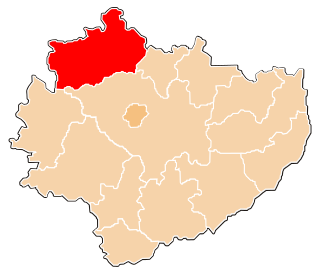
Januszewice is a village in the administrative district of Gmina Opoczno, within Opoczno County, Łódź Voivodeship, in central Poland. It lies approximately 5 kilometres (3 mi) west of Opoczno and 68 km (42 mi) south-east of the regional capital Łódź.
Modrzew is a village in the administrative district of Gmina Opoczno, within Opoczno County, Łódź Voivodeship, in central Poland. It lies approximately 8 kilometres (5 mi) north-west of Opoczno and 65 km (40 mi) south-east of the regional capital Łódź.
Modrzewek is a village in the administrative district of Gmina Opoczno, within Opoczno County, Łódź Voivodeship, in central Poland. It lies approximately 9 kilometres (6 mi) north-west of Opoczno and 64 km (40 mi) south-east of the regional capital Łódź.
Chełsty is a village in the administrative district of Gmina Żarnów, within Opoczno County, Łódź Voivodeship, in central Poland. It lies approximately 4 kilometres (2 mi) south-west of Żarnów, 21 km (13 mi) south-west of Opoczno, and 79 km (49 mi) south-east of the regional capital Łódź.
Dąbie is a village in the administrative district of Gmina Żarnów, within Opoczno County, Łódź Voivodeship, in central Poland. It lies approximately 7 kilometres (4 mi) southwest of Żarnów, 24 km (15 mi) south-west of Opoczno, and 77 km (48 mi) south-east of the regional capital Łódź.
Klew is a village in the administrative district of Gmina Żarnów, within Opoczno County, Łódź Voivodeship, in central Poland. It lies approximately 10 kilometres (6 mi) west of Żarnów, 25 km (16 mi) south-west of Opoczno, and 75 km (47 mi) south-east of the regional capital Łódź.
Marcinków is a village in the administrative district of Gmina Żarnów, within Opoczno County, Łódź Voivodeship, in central Poland. It lies approximately 5 kilometres (3 mi) south-west of Żarnów, 22 km (14 mi) south-west of Opoczno, and 79 km (49 mi) south-east of the regional capital Łódź.
Nadole is a village in the administrative district of Gmina Żarnów, within Opoczno County, Łódź Voivodeship, in central Poland. It lies approximately 4 kilometres (2 mi) north-east of Żarnów, 14 km (9 mi) south of Opoczno, and 78 km (48 mi) south-east of the regional capital Łódź.
Tomaszów is a village in the administrative district of Gmina Żarnów, within Opoczno County, Łódź Voivodeship, in central Poland. It lies approximately 6 kilometres (4 mi) south-west of Żarnów, 22 km (14 mi) south-west of Opoczno, and 78 km (48 mi) south-east of the regional capital Łódź.
Mała Wola is a village in the administrative district of Gmina Czerniewice, within Tomaszów Mazowiecki County, Łódź Voivodeship, in central Poland. It lies approximately 5 kilometres (3 mi) south-east of Czerniewice, 19 km (12 mi) north-east of Tomaszów Mazowiecki, and 55 km (34 mi) east of the regional capital Łódź.
Julianów is a village in the administrative district of Gmina Fałków, within Końskie County, Świętokrzyskie Voivodeship, in south-central Poland. It lies approximately 5 kilometres (3 mi) west of Fałków, 28 km (17 mi) west of Końskie, and 50 km (31 mi) north-west of the regional capital Kielce.
Pikule is a village in the administrative district of Gmina Fałków, within Końskie County, Świętokrzyskie Voivodeship, in south-central Poland. It lies approximately 8 kilometres (5 mi) south-west of Fałków, 30 km (19 mi) south-west of Końskie, and 47 km (29 mi) north-west of the regional capital Kielce.
Reczków is a village in the administrative district of Gmina Fałków, within Końskie County, Świętokrzyskie Voivodeship, in south-central Poland. It lies approximately 9 kilometres (6 mi) north-west of Fałków, 27 km (17 mi) west of Końskie, and 54 km (34 mi) north-west of the regional capital Kielce.
Rudka is a village in the administrative district of Gmina Fałków, within Końskie County, Świętokrzyskie Voivodeship, in south-central Poland. It lies approximately 2 kilometres (1 mi) west of Fałków, 25 km (16 mi) west of Końskie, and 47 km (29 mi) north-west of the regional capital Kielce.
Cyganka is a village in the administrative district of Gmina Dębe Wielkie, within Mińsk County, Masovian Voivodeship, in east-central Poland. It lies approximately 4 kilometres (2 mi) north-east of Dębe Wielkie, 6 km (4 mi) north-west of Mińsk Mazowiecki, and 35 km (22 mi) east of Warsaw.
Brzozówka is a village in the administrative district of Gmina Kadzidło, within Ostrołęka County, Masovian Voivodeship, in east-central Poland. It lies approximately 3 kilometres (2 mi) south-east of Kadzidło, 18 km (11 mi) north of Ostrołęka, and 116 km (72 mi) north of Warsaw.
Cholewy is a village in the administrative district of Gmina Błonie, within Warsaw West County, Masovian Voivodeship, in east-central Poland. It lies approximately 9 kilometres (6 mi) west of Błonie, 21 km (13 mi) west of Ożarów Mazowiecki, and 35 km (22 mi) west of Warsaw.
Kębłowo is a village in the administrative district of Gmina Miłosław, within Września County, Greater Poland Voivodeship, in west-central Poland. It lies approximately 2 kilometres (1 mi) north-east of Miłosław, 15 km (9 mi) south-west of Września, and 45 km (28 mi) south-east of the regional capital Poznań.