
The East Branch Delaware River is one of two branches that form the Delaware River. It is approximately 75 mi (121 km) long, and flows through the U.S. state of New York. It winds through a mountainous area on the southwestern edge of Catskill Park in the Catskill Mountains for most of its course, before joining the West Branch along the northeast border of Pennsylvania with New York. For a long stretch it serves as the Blue Line, the park's boundary. Much of it is paralleled by State Route 30.

A body of water or waterbody is any significant accumulation of water, generally on a planet's surface. The term most often refers to oceans, seas, and lakes, but it includes smaller pools of water such as ponds, wetlands, or more rarely, puddles. A body of water does not have to be still or contained; rivers, streams, canals, and other geographical features where water moves from one place to another are also considered bodies of water.

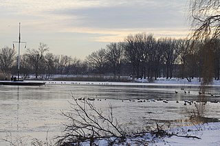
Silver Lake is the name of both a reservoir and an adjacent neighborhood in the New York City borough of Staten Island.
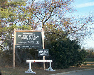
Valley Stream State Park is a 97-acre (0.39 km2) state park located in the village of Valley Stream in Nassau County, New York. The park is one of three state parks located in the Town of Hempstead on Long Island. Like Hempstead Lake State Park, Valley Stream State Park contained Cornell's Pond, a feeder reservoir for the Ridgewood Reservoir.

Hempstead Lake State Park is a 737-acre (2.98 km2) state park located in Nassau County, New York in the United States. The park is located in West Hempstead and is one of three state parks within the Town of Hempstead. There is a quick-access entrance at exit 18 from the Southern State Parkway. The park contains the largest freshwater lake in Nassau County.

A riparian forest or riparian woodland is a forested or wooded area of land adjacent to a body of water such as a river, stream, pond, lake, marshland, estuary, canal, sink or reservoir.

Esopus Creek is a 65.4-mile-long (105.3 km) tributary of the Hudson River that drains the east-central Catskill Mountains in the U.S. state of New York. From its source at Winnisook Lake on the slopes of Slide Mountain, the Catskills' highest peak, it flows across Ulster County to the Hudson at Saugerties. Many tributaries extend its watershed into neighboring Greene County and a small portion of Delaware County. Midway along its length, it is impounded at Olive Bridge to create Ashokan Reservoir, the first of several built in the Catskills as part of New York City's water supply system. Its own flow is supplemented 13 miles (21 km) above the reservoir by the Shandaken Tunnel, which carries water from the city's Schoharie Reservoir into the creek.

Brown's Station, New York was a hamlet in the Esopus Valley of southeastern Ulster County, New York, United States. It was submerged by the waters of the Ashokan Reservoir, an artificial lake built between 1906 and 1915 to supply fresh water to New York City.

Fishkill Creek is a tributary of the Hudson River in Dutchess County, New York, United States. At 33.5 miles (53.9 km) it is the second longest stream in the county, after Wappinger Creek. It rises in the town of Union Vale and flows generally southwest to a small estuary on the Hudson just south of Beacon. Part of its 193-square-mile (500 km2) watershed is in Putnam County to the south. Sprout Creek, the county's third-longest creek, is its most significant tributary. Whaley and Sylvan lakes and Beacon Reservoir, its largest, deepest and highest lakes, are among the bodies of water within the watershed.
Lake Washington is the primary reservoir for the city of Newburgh, New York, United States. It is located just southwest of the city, lying partially within it and the neighboring towns of Newburgh and New Windsor. It holds approximately 1.5 billion US gallons (5,700,000 m3), an amount equivalent to the city's annual consumption.

The Seven Mile River or Sevenmile River is a 9.6-mile-long (15.4 km) stream in central Massachusetts. It heads at Browning Pond, at the Oakham and Spencer border, and travels south through Spencer, following a short distance from State Route 31. It crosses under Route 31 the highway becomes Pleasant Street, then continues south along Old Meadow Road and under State Route 9 near the junction of State Route 49. It then parallels Route 9 to its south until it joins the East Brookfield River between Lake Lashaway and Quaboag Pond.

The Croton Distributing Reservoir, also known as the Murray Hill Reservoir, was an above-ground reservoir at 42nd Street and Fifth Avenue in the New York City borough of Manhattan. Covering 4-acre (16,000 m2) and holding 20 million US gallons (76,000 m3), it supplied the city with drinking water during the 19th century. Its massive 50-foot-high (15 m) granite walls, which presented a vaguely Egyptian-style facade, were 25 feet (7.6 m) thick. Atop the walls was a public promenade offering panoramic views; Edgar Allan Poe enjoyed walking there.
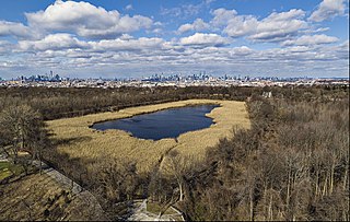
Ridgewood Reservoir is a decommissioned 19th century reservoir and freshwater wetland that sits on the Brooklyn–Queens border in New York City, within what is now Highland Park. Although the reservoir was originally built to secure a reliable water supply for the City of Brooklyn, it is positioned on the Queens side of the border in the neighborhood of Glendale. The reservoir and park are bounded on the north by the Jackie Robinson Parkway, on the south by Highland Boulevard, on the west by Vermont Place and on the east by Cypress Hills National Cemetery.

The Great Lawn and Turtle Pond are two connected features of Central Park in Manhattan, New York City, United States. The lawn and pond are located on the site of a former reservoir for the Croton Aqueduct system which was infilled during the early 20th century.

The Jacqueline Kennedy Onassis Reservoir, also known as Central Park Reservoir, is a decommissioned reservoir in Central Park in the borough of Manhattan, New York City, stretching from 86th to 96th Streets. It covers 106 acres (43 ha) and holds over 1,000,000,000 US gallons (3,800,000 m3) of water.

The Brooklyn Waterworks, also known as the Milburn Pumping Station, was a historic building in Freeport, Long Island. Designed by noted Brooklyn architect Frank Freeman and completed in 1890, it was described as "Long Island's most ambitious Romanesque Revival design."
Otter Kill is a 16.0-mile-long (25.7 km) tributary of Moodna Creek that flows through central Orange County, New York, in the United States. Via the Moodna, which it forms at a confluence with Cromline Creek north of the village of Washingtonville, its waters eventually reach the Hudson River.

Stony Brook is a stream largely running through Lincoln and Weston, Massachusetts, then forming the Weston/Waltham boundary, and emptying into the Charles River across from the Waltham/Newton boundary. It has two tributaries, Cherry Brook and Hobbs Brook, and its watershed includes about half of Lincoln and Weston as well as parts of Lexington and Waltham. Since 1887, it has been the water supply for Cambridge, along with the Hobbs Brook Reservoir.
Baisley Pond Park is a public park located in the southeastern part of Queens, New York City, bordering the neighborhoods of South Jamaica, Rochdale, and St. Albans. It covers 109.61 acres (44.36 ha), including the 30-acre (12 ha) Baisley Pond in the center of the park. It is maintained by the New York City Department of Parks and Recreation.

East Kill, a 16-mile-long (26 km) tributary of Schoharie Creek, flows across the town of Jewett, New York, United States, from its source on Stoppel Point. Ultimately its waters reach the Hudson River via the Mohawk. Since it drains into the Schoharie upstream of Schoharie Reservoir, it is part of the New York City water supply system. East Kill drains the southern slopes of the Blackhead Mountains, which include Thomas Cole Mountain, Black Dome, and Blackhead Mountain, the fourth-, third-, and fifth-highest peaks in the Catskills, respectively.


