
A ghost town, deserted city, extinct town or abandoned city is an abandoned settlement, usually one that contains substantial visible remaining buildings and infrastructure such as roads. A town often becomes a ghost town because the economic activity that supported it has failed or ended for any reason. The town may also have declined because of natural or human-caused disasters such as floods, prolonged droughts, extreme heat or extreme cold, government actions, uncontrolled lawlessness, war, pollution, or nuclear and radiation accidents and incidents. The term can sometimes refer to cities, towns, and neighborhoods that, though still populated, are significantly less so than in past years; for example, those affected by high levels of unemployment and dereliction.
Grimsby is a town on Lake Ontario in the Niagara Region, Ontario, Canada. Grimsby is at the eastern end of the Hamilton Census Metropolitan Area. It is named after the English fishing town of Grimsby in north-east Lincolnshire. The majority of residents reside in the area bounded by Lake Ontario and the Niagara Escarpment, home to a section of the Bruce Trail.

Georgina is a town in south-central Ontario, and the northernmost municipality in the Regional Municipality of York. The town is bounded to the north by Lake Simcoe. Although incorporated as a town, it operates as a township in which dispersed communities share a common administrative council. The largest communities are Keswick, Sutton and Jackson's Point. Smaller communities include Pefferlaw, Port Bolster, Roches Point, Udora and Willow Beach. The town was formed by the merger of the Village of Sutton, the Township of Georgina and the Township of North Gwillimbury in 1971 and incorporated in 1986. North Gwillimbury had previously been part of Georgina but became its own township in 1826. It took its name from the family of Elizabeth Simcoe, née Gwillim.
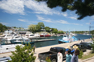
Tobermory is a small community located at the northern tip of the Bruce Peninsula, in the traditional territory of the Saugeen Ojibway Nation. Until European colonization in the mid-19th century, the Bruce Peninsula was home to the Saugeen Ojibway nations, with their earliest ancestors reaching the area as early as 7,500 years ago. It is part of the municipality of Northern Bruce Peninsula. It is 300 kilometres northwest of Toronto. The closest city to Tobermory is Owen Sound, 100 kilometres south of Tobermory and connected by Highway 6.

The Junction is a neighbourhood in Toronto, Ontario, Canada, that is near the West Toronto Diamond, a junction of four railway lines in the area. The neighbourhood was previously an independent city called West Toronto, that was also its own federal electoral district until amalgamating with the city of Toronto in 1909. The main intersection of the area is Dundas Street West and Keele Street. The Stockyards is the northeastern quadrant of the neighbourhood.
Havelock-Belmont-Methuen is a township in central-eastern Ontario, Canada, in Peterborough County. On January 1, 1998, Belmont and Methuen Township amalgamated with the Village of Havelock to form what is now Havelock-Belmont-Methuen.

Walden was a town in the Canadian province of Ontario, which existed from 1973 to 2000. Created as part of the Regional Municipality of Sudbury when regional government was introduced, the town was dissolved when the city of Greater Sudbury was incorporated on January 1, 2001. The name Walden continues to be informally used to designate the area.

Nickel Centre was a town in Ontario, Canada, which existed from 1973 to 2000.

The Opeongo River is a river in the Saint Lawrence River drainage basin in Nipissing District in northeastern Ontario, Canada. The river is entirely within Algonquin Provincial Park and Opeongo River Provincial Park, except for a small portion around Victoria Lake, and is a left tributary of the Madawaska River.

Opeongo Lake is a lake in the Saint Lawrence River drainage basin in the geographic townships of Bower, Dickson, Preston and Sproule in the Unorganized South Part of Nipissing District in Northeastern Ontario, Canada. It is the largest lake in Algonquin Provincial Park and the source of the Opeongo River. The lake's name comes from the Algonquian word opeauwingauk meaning "sandy narrows".
Opeongo River Provincial Park is a waterway park in Nipissing District in northeastern Ontario, Canada. It incorporates those portions of the Opeongo River from its exit from Algonquin Provincial Park to the river's mouth at the Madawaska River, except for a small portion around Victoria Lake. The park has two access points: from Ontario Highway 60 west of the community of Madawaska; and the Shall Lake access point, north of Victoria Lake, in Algonquin Provincial Park.
Little Britain is a compact rural community in the City of Kawartha Lakes, Ontario, Canada. It is located 15 kilometres (9.3 mi) southwest of Lindsay. Formerly a part of Mariposa Township and Victoria County, Little Britain is now part of Ward 4, City of Kawartha Lakes.

Craigmont is a dispersed rural community, unincorporated place, and ghost town in Carlow/Mayo, Hastings County in Central Ontario, Canada. It lies adjacent to the municipal boundary with Brudenell, Lyndoch and Raglan in Renfrew County. It was a former mining town that produced corundum from deposits in Mount Robillard, directly north of the community.

Wollaston is an incorporated township in Hastings County, Ontario, Canada. The township had a population of 670 in the Canada 2016 Census.
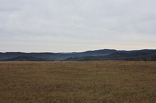
The Opeongo Hills are a range of hills in Southern Ontario, near Algonquin Provincial Park. The hills stretch from Opeongo Lake in Algonquin Park in the west, along the Madawaska and Opeongo Rivers, towards the Opeongo Colonization Road, and extending towards the Deacon Escarpment, Bonnechere, Ontario, and Dacre in the east. To the east of the Opeongo Hills lie the Madawaska River valley, the Mississippi River Valley, and the Ottawa-Bonnechere Graben along the Ottawa River. Its tallest peak is roughly 7 km northeast of Highway 60. At roughly 586 meters, it is the tallest point in Southern Ontario. The community of Foymount is one of the highest settlements in Southern Ontario.
Benny is an unincorporated community in the geographic township of Moncrieff in the Unorganized North Part of Sudbury District in Northeastern Ontario, Canada. It is located on Bannerman Creek west of Ontario Highway 144 and about 11 kilometres (7 mi) northwest of the community of Cartier. Benny is on the Canadian Pacific Railway transcontinental main line and has a siding, and it is the location of the Benny railway station flag stop on the Via Rail Sudbury – White River train service.
The history of Richmond Hill began when the First Nations came and settled in the area. With the Toronto Purchase, the city gradually expanded with new greenhouse industries and improved transportation infrastructure.

