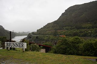
 Wallsend (left) and Taylorville (right), the two major settlements of Brunner Borough
 Taylorville Bridge seen from the Wallsend side of the Grey River
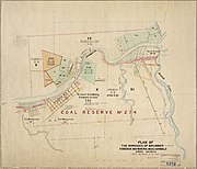 Map of Brunner Borough


Related Research Articles
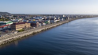
Greymouth is the largest town in the West Coast region in the South Island of New Zealand, and the seat of the Grey District Council. The population of the whole Grey District is 14,250, which accounts for 43% of the West Coast's inhabitants. The Greymouth urban area had an estimated population of 8,340. A large proportion of the District, 65%, is part of the Conservation Estate owned and managed by the Department of Conservation making Greymouth a natural centre for walkers and trampers.
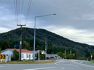
Brunner, originally called Brunnerton, is a town in the northwest of New Zealand's South Island. It is 12 kilometres (7 mi) east of Greymouth, on the south bank of the Grey River. It is on the Midland Line railway near its junction with the Stillwater–Westport Line (SWL) in neighbouring Stillwater. Passenger trains ceased running along the SWL to Reefton and Westport in 1967, but the TranzAlpine runs the length of the Midland Line from Christchurch to Greymouth and it continues to stop in Brunner.

The Stillwater Ngākawau Line (SNL), formerly the Stillwater–Westport Line (SWL) and the Ngakawau Branch, is a secondary main line, part of New Zealand's national rail network. It runs between Stillwater and Ngakawau via Westport on the West Coast of the South Island. It was one of the longest construction projects in New Zealand's history, with its first section, at the south end, opened in 1889, and the beginnings of the Ngākawau Branch, at its Westport end, in 1875. The full line was completed in 1942. The only slower railway projects were Palmerston North to Gisborne, 1872 to 1942, and the Main North Line to Picton, 1872 to 1945.
Stillwater is a town in the South Island of New Zealand east of Greymouth on the banks of the Grey River, at the confluence with the Arnold River, in the Grey District of the West Coast, next to Brunner. There is also a Stillwater, Auckland in the North Island.
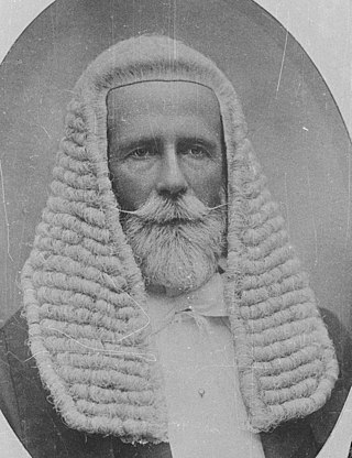
Sir Arthur Robert Guinness was a New Zealand politician, and Speaker of the House of Representatives.

The Brunner Mine was a coal mine on the West Coast of the South Island in New Zealand.
Grey Valley is a former parliamentary electorate in the West Coast region of New Zealand. The electorate was created for the 1871 general election as a single-member electorate, became a two-member electorate for the 1876 general election, and was split between the single-member electorates of Greymouth and Inangahua for the 1881 general election.

Joseph Petrie was a 19th-century Member of Parliament from Westland, New Zealand.
William Henry Harrison was a 19th-century journalist from Greymouth who represented two Westland electorates in the New Zealand House of Representatives.
John Bevan was a 19th-century member of the House of Representatives. He was an auctioneer and merchant from Hokitika on the West Coast of New Zealand.
Grey County was one of the counties of New Zealand in the South Island.

Taylorville is a small town on the banks of the Grey River, It is roughly 10 kilometers from the mouth of the river in Greymouth.
The Westland Boroughs by-election 1868 was a by-election held in the Westland Boroughs electorate during the 4th New Zealand Parliament, on 3 April 1868.
James Kerr was an editor and politician. He was a member of the New Zealand Legislative Council from 1892 until his death.

Westland County, also known as County of Westland, was a local government area on the West Coast of New Zealand's South Island. It existed from 1868 to 1873, and then from 1876 until 1989. In its first incarnation, it constituted the government for the area that was split from the Canterbury Province, with the West Coast Gold Rush having given the impetus for that split. It had the same administrative powers as a provincial council, but the legislative power rested with Parliament in Wellington. The first Westland County was the predecessor to Westland Province.
The Mayor of Grey, often referred to as the Mayor of Greymouth, officiates over the Grey District of New Zealand which is administered by the Grey District Council with its seat in Greymouth. The current Mayor is Tania Gibson. Two predecessors to this office were the Mayor of Greymouth, officiating over the Greymouth Borough Council from 1868, and from 1877 the chairman of the Grey County Council.
The Greymouth Borough was the borough council covering the urban part of Greymouth, New Zealand between 1868 and 1989, when it became part of Grey District.
George William York was a New Zealand Anglican priest from the 1880s onwards.

Wallsend is a locality in the West Coast region of New Zealand, located on the south side of the Grey River. It is located opposite Taylorville. The two settlements were connected via a suspension bridge for pedestrians that was known as the Taylorville bridge.

The Westland Pioneers' Memorial is a statue in Hokitika, New Zealand, commemorating the pioneer settlers of Westland. Unveiled in 1914, the statue had its right arm broken off in 2009 and was subsequently dubbed Venus de Hokitika. The memorial was relocated in 2016 from its original location on the side of State Highway 6 to the centre of a roundabout in one of Hokitika's main streets.
References
- ↑ "Grey County Council". Grey River Argus. Vol. XXXV, no. 5974. 8 September 1887. p. 2. Retrieved 1 September 2020.
- ↑ "Public Notices". Grey River Argus. Vol. XXXV, no. 6032. 7 November 1887. p. 2. Retrieved 1 September 2020.
- ↑ "Brunnerton". Grey River Argus. Vol. XXXV, no. 6044. 22 November 1887. p. 2. Retrieved 1 September 2020.
- ↑ "Brunnerton". Grey River Argus. Vol. XXXV, no. 6045. 23 November 1887. p. 2. Retrieved 1 September 2020.
- ↑ "Grey River Argus". Vol. XXXV, no. 6049. 28 November 1887. p. 2. Retrieved 1 September 2020.
- ↑ "Borough of Brunnerton". Grey River Argus. Vol. XXXV, no. 6048. 26 November 1887. p. 2. Retrieved 1 September 2020.
- ↑ "Brunnerton". Grey River Argus. Vol. XXXV, no. 6049. 28 November 1887. p. 4. Retrieved 1 September 2020.
- ↑ "Brunnerton". Grey River Argus. Vol. XXXIV, no. 5825. 21 February 1887. p. 2. Retrieved 1 September 2020.
- ↑ "Brunnerton Borough Council". Grey River Argus. Vol. XXXV, no. 6058. 8 December 1887. p. 2. Retrieved 1 September 2020.
- ↑ "Bridge collapses". Greymouth Evening Star . 19 January 1920. p. 5. Retrieved 1 September 2020.
- ↑ Cyclopedia Company Limited (1906). "Brunnerton". The Cyclopedia of New Zealand : Nelson, Marlborough & Westland Provincial Districts. Christchurch: The Cyclopedia of New Zealand.
- ↑ The New Zealand Official Year-Book, 1951-52. Wellington: Statistics New Zealand. 1952. Retrieved 1 September 2020.