A dam is a barrier that stops or restricts the flow of water or underground streams. Reservoirs created by dams not only suppress floods but also provide water for activities such as irrigation, human consumption, industrial use, aquaculture, and navigability. Hydropower is often used in conjunction with dams to generate electricity. A dam can also be used to collect water or for storage of water which can be evenly distributed between locations. Dams generally serve the primary purpose of retaining water, while other structures such as floodgates or levees are used to manage or prevent water flow into specific land regions. The earliest known dam is the Jawa Dam in Jordan, dating to 3,000 BC.
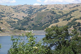
Calaveras Reservoir is located primarily in Santa Clara County, California, with a small portion and its dam in Alameda County, California. The reservoir capacity is seismically restricted, approximately 30,000 acre⋅ft (37,000,000 m3). In Spanish, Calaveras means "skulls".
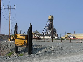
The Giant Mine was a gold mine located on the Ingraham Trail, 5 km (3.1 mi) north of Yellowknife, Northwest Territories. Giant Mine is within the Kam Group, which is part of the Yellowknife greenstone belt. Gold was discovered on the property and mineral claims staked in 1935 by Johnny Baker, but the true extent of the gold deposits was not known until 1944, when a massive gold-bearing shear zone was uncovered beneath the drift-filled Baker Creek Valley.
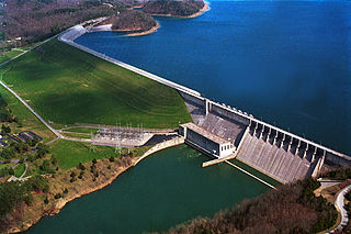
The Wolf Creek Dam is a multi-purpose dam on the Cumberland River in the western part of Russell County, Kentucky, United States. The dam serves at once four distinct purposes: it generates hydroelectricity; it regulates and limits flooding; it releases stored water to permit year-round navigation on the lower Cumberland River; and it creates Lake Cumberland for recreation, which has become a popular tourist attraction. Because of seepage problems in the dam's foundation, it has become the U.S. Army Corps of Engineers's top dam priority. U.S. Route 127 is built on top of the dam.
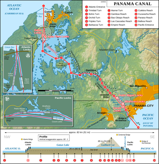
The Panama Canal locks are a lock system that lifts a ship up 85 feet to the main elevation of the Panama Canal and down again. The original canal had a total of six steps for a ship's passage. The total length of the lock structures, including the approach walls, is over 1.9 miles (3 km). The locks were one of the greatest engineering works ever to be undertaken when they opened in 1914. No other concrete construction of comparable size was undertaken until the Hoover Dam, in the 1930s.

The Tinaroo Dam, officially the Tinaroo Falls Dam, is a major ungated concrete gravity dam with a central ogee spillway across the Barron River located on the Atherton Tableland in Far North Queensland, Australia. The dam's purpose includes irrigation for the Mareeba-Dimbulah Irrigation Scheme, water supply, hydroelectricity, and recreation. Completed between 1953 and 1958, the dam creates the impounded reservoir, Lake Tinaroo.

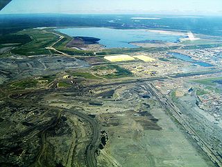
The Ok Tedi environmental disaster caused severe harm to the environment along 1,000 kilometres (620 mi) of the Ok Tedi River and the Fly River in the Western Province of Papua New Guinea between about 1984 and 2013. The lives of 50,000 people have been disrupted. One of the worst environmental disasters caused by humans, it is a consequence of the discharge of about two billion tons of untreated mining waste into the Ok Tedi from the Ok Tedi Mine, an open pit mine in the Western Province of Papua New Guinea.

Mosul Dam, formerly known as Saddam Dam, is the largest dam in Iraq. It is located on the Tigris river in the western governorate of Ninawa, upstream of the city of Mosul. The dam serves to generate hydroelectricity and provide water for downstream irrigation. At full capacity, the structure holds about 11.1 cubic kilometres (2.7 cu mi) of water and provides electricity to the 1.7 million residents of Mosul.

Spring Creek Debris Dam is an earthfill dam on Spring Creek, a tributary of the Sacramento River, in Shasta County in the U.S. state of California. Completed in 1963, the dam, maintained by the U.S. Bureau of Reclamation, serves primarily to collect severe acid mine drainage stemming from the Iron Mountain Mine. The dam forms the Spring Creek Reservoir, less than 1 mile (1.6 km) long. Spring Creek and South Fork Spring Creek flow into the reservoir from a 16-square-mile (41 km2) watershed. The dam is directly upstream from the city of Keswick, California and the Keswick Reservoir. The operation is part of the Trinity River Division of the Central Valley Project.

Maraetai Power Station is a hydroelectric power station on the Waikato River, in the North Island of New Zealand. It is the fifth of the eight hydroelectric power stations on the Waikato River, and at 360 MW, is the largest hydroelectric station on the Waikato.

Deriner Dam is a concrete double-curved arch dam on the Çoruh River 5 km (3.1 mi) east of Artvin in Artvin Province, Turkey. The main purpose of the dam is hydroelectric power production and additionally flood control. Construction on the dam began in 1998, the reservoir began to fill in February 2012 and the power station was completed by February 2013. It will have a 670 MW power house and is the tallest dam in Turkey. The dam is being implemented by Turkey's State Hydraulic Works and constructed by a consortium of Turkish, Russian and Swiss companies.

The San Vicente Dam is a concrete gravity dam on San Vicente Creek near Lakeside and 25 km (15.5 mi) northeast of San Diego, California. The dam was built between 1941 and 1943 and created San Vicente Reservoir for the purpose of municipal water storage, flood control and recreation. Although the reservoir is fed by run-off, its main source is the First San Diego Aqueduct. In June 2009, construction to raise the height of the dam by 117 ft (36 m), in order to more than double its reservoir size, commenced. It is the largest dam raise in the United States and largest roller-compacted concrete dam raise in the world. The dam raise project was originally set for the end of 2012, but was completed in early 2014. Efforts to replace the water supply pipelines and prepare the reservoir for the public will be underway until 2015-2017.

Vittoria Light also known as the Victory Lighthouse, is an active lighthouse in Trieste, Italy, serving the Gulf of Trieste. It is located on the hill of Gretta, off the Strada del Friuli. At a height of 223 feet (68 m) it is one of the tallest lighthouses in the world.

Thompson Creek Metals Company Inc. was a full cycle mining company with acquisition, exploration, development, and operation in North America. The corporate office was located in Denver, Colorado. The company primarily produced copper, gold, and molybdenum. Over its history, the Company evolved from being a major primary molybdenum producer to becoming a copper and gold mining company with the construction and development of the Mount Milligan mine and concentrator in British Columbia, Canada. Mount Milligan was Thompson Creek Metals principal operation and the company owned 100% of this property. The company also owned 100% of its Thompson Creek Mine in Idaho. Thompson Creek Metals owned 75% joint venture interest in two other properties, including its Endako Mine in British Columbia, and its Langeloth Metallurgical Facility (roaster) in Pennsylvania. Thompson Creek Metals had additional development projects, including the Berg property in British Columbia.
The Los Leones Dam is a tailings dam on Los Leones River, a tributary of Blanco River, about 56 km (35 mi) northeast of Santiago, in Los Andes Province, Chile. The dam was constructed in segments between 1980 and 1999 and is now used only for emergencies. The dam is 135 m (443 ft) tall on its upstream face and 200 m (656 ft) tall on its downstream face. The height at its axis though is 160 m (525 ft). It is one of the tallest tailings dams in the world.

The Antamina Tailings Dam, also known as the Antamina Tailings Impoundment Facility, is a tailings dam located in the Huincush Ravine 55 km (34 mi) east of Huaraz in the Ancash Region of Peru. The purpose of the dam is to store tailings processed at the nearby Antamina mine. In 2003, Golder Associates, Burnaby, B.C. was awarded the 2002 Canadian Consulting Engineering Award for its innovative design of the dam.

The Mount Polley mine disaster is an environmental disaster in the Cariboo region of central British Columbia, Canada, that began 4 August 2014 with a breach of the Imperial Metals-owned Mount Polley copper and gold mine tailings pond, releasing its water and slurry with years worth of mining waste into Polley Lake. The spill flooded Polley Lake, its outflow Hazeltine Creek, and continued into nearby Quesnel Lake and Cariboo River. By 8 August the four-square-kilometre (1.5 sq mi) sized tailings pond had been emptied of the majority of supernatant that sits atop the settled solids. Water tests showed elevated levels of selenium, arsenic and other metals similar to historical tests before the disaster. The cause of the dam break has been investigated with a final report published 31 January 2015. Imperial Metals had a history of operating the pond beyond capacity since at least 2011.
Zerbe Run is a tributary of Mahanoy Creek in Northumberland County, Pennsylvania, in the United States. It is approximately 8.3 miles (13.4 km) long and flows through Coal Township, Zerbe Township, and Little Mahanoy Township. The watershed of the stream has an area of 13.1 square miles (34 km2). Part of the stream is impaired by abandoned mine drainage, but its upper reaches are not impacted by mining. Several mine drainage discharges occur within the watershed. The stream is not far from the Western Middle Anthracite Field.

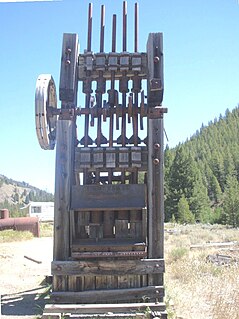
Homeward Bound Battery and Dam is a heritage-listed stamping mill and reservoir at Croydon, Shire of Croydon, Queensland, Australia. It was built in 1888 by Mr Schumacher. It was added to the Queensland Heritage Register on 21 October 1992.