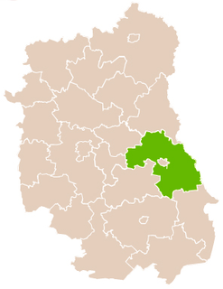
Kicin is a village in the administrative district of Gmina Białopole, within Chełm County, Lublin Voivodeship, in eastern Poland. It lies approximately 3 kilometres (2 mi) east of Białopole, 28 km (17 mi) south-east of Chełm, and 89 km (55 mi) east of the regional capital Lublin.
Strzelce is a village in the administrative district of Gmina Białopole, within Chełm County, Lublin Voivodeship, in eastern Poland. It lies approximately 5 kilometres (3 mi) east of Białopole, 31 km (19 mi) south-east of Chełm, and 92 km (57 mi) east of the regional capital Lublin.
Barbarówka is a village in the administrative district of Gmina Dorohusk, within Chełm County, Lublin Voivodeship, in eastern Poland, close to the border with Ukraine. It lies approximately 6 kilometres (4 mi) south-west of Dorohusk, 19 km (12 mi) east of Chełm, and 84 km (52 mi) east of the regional capital Lublin.
Teosin is a village in the administrative district of Gmina Dorohusk, within Chełm County, Lublin Voivodeship, in eastern Poland, close to the border with Ukraine. It lies approximately 6 kilometres (4 mi) west of Dorohusk, 19 km (12 mi) east of Chełm, and 84 km (52 mi) east of the regional capital Lublin.
Józefów is a village in the administrative district of Gmina Dubienka, within Chełm County, Lublin Voivodeship, in eastern Poland, close to the border with Ukraine. It lies approximately 8 kilometres (5 mi) south of Dubienka, 34 km (21 mi) south-east of Chełm, and 97 km (60 mi) east of the regional capital Lublin.
Zagórnik is a village in the administrative district of Gmina Dubienka, within Chełm County, Lublin Voivodeship, in eastern Poland, close to the border with Ukraine. It lies approximately 9 kilometres (6 mi) south-east of Dubienka, 37 km (23 mi) south-east of Chełm, and 100 km (62 mi) east of the regional capital Lublin.
Alojzów is a village in the administrative district of Gmina Leśniowice, within Chełm County, Lublin Voivodeship, in eastern Poland. It lies approximately 5 kilometres (3 mi) east of Leśniowice, 20 km (12 mi) south of Chełm, and 75 km (47 mi) south-east of the regional capital Lublin.
Politówka is a village in the administrative district of Gmina Leśniowice, within Chełm County, Lublin Voivodeship, in eastern Poland. It lies approximately 3 kilometres (2 mi) east of Leśniowice, 19 km (12 mi) south of Chełm, and 73 km (45 mi) south-east of the regional capital Lublin.
Poniatówka is a village in the administrative district of Gmina Leśniowice, within Chełm County, Lublin Voivodeship, in eastern Poland. It lies approximately 22 kilometres (14 mi) south of Chełm and 78 km (48 mi) south-east of the regional capital Lublin.
Rakołupy is a village in the administrative district of Gmina Leśniowice, within Chełm County, Lublin Voivodeship, in eastern Poland. It lies approximately 21 kilometres (13 mi) south of Chełm and 69 km (43 mi) south-east of the regional capital Lublin.
Sarniak is a village in the administrative district of Gmina Leśniowice, within Chełm County, Lublin Voivodeship, in eastern Poland. It lies approximately 22 kilometres (14 mi) south of Chełm and 77 km (48 mi) south-east of the regional capital Lublin.
Wygnańce is a village in the administrative district of Gmina Leśniowice, within Chełm County, Lublin Voivodeship, in eastern Poland. It lies approximately 22 kilometres (14 mi) south of Chełm and 79 km (49 mi) south-east of the regional capital Lublin.
Huta is a village in the administrative district of Gmina Wojsławice, within Chełm County, Lublin Voivodeship, in eastern Poland. It lies approximately 5 kilometres (3 mi) north-east of Wojsławice, 26 km (16 mi) south of Chełm, and 81 km (50 mi) south-east of the regional capital Lublin.
Ostrów-Kolonia is a village in the administrative district of Gmina Wojsławice, within Chełm County, Lublin Voivodeship, in eastern Poland. It lies approximately 7 kilometres (4 mi) north-west of Wojsławice, 24 km (15 mi) south of Chełm, and 72 km (45 mi) south-east of the regional capital Lublin.
Partyzancka Kolonia is a village in the administrative district of Gmina Wojsławice, within Chełm County, Lublin Voivodeship, in eastern Poland. It lies approximately 3 kilometres (2 mi) east of Wojsławice, 28 km (17 mi) south of Chełm, and 80 km (50 mi) south-east of the regional capital Lublin.
Rozięcin is a village in the administrative district of Gmina Wojsławice, within Chełm County, Lublin Voivodeship, in eastern Poland. It lies approximately 4 kilometres (2 mi) south-east of Wojsławice, 29 km (18 mi) south of Chełm, and 81 km (50 mi) south-east of the regional capital Lublin.
Stary Majdan is a village in the administrative district of Gmina Wojsławice, within Chełm County, Lublin Voivodeship, in eastern Poland. It lies approximately 5 kilometres (3 mi) south-west of Wojsławice, 28 km (17 mi) south of Chełm, and 76 km (47 mi) south-east of the regional capital Lublin.
Turowiec is a village in the administrative district of Gmina Wojsławice, within Chełm County, Lublin Voivodeship, in eastern Poland. It lies approximately 7 kilometres (4 mi) north-east of Wojsławice, 25 km (16 mi) south-east of Chełm, and 82 km (51 mi) south-east of the regional capital Lublin.
Wólka Putnowicka is a village in the administrative district of Gmina Wojsławice, within Chełm County, Lublin Voivodeship, in eastern Poland. It lies approximately 10 kilometres (6 mi) east of Wojsławice, 26 km (16 mi) south-east of Chełm, and 84 km (52 mi) south-east of the regional capital Lublin.
Syczów is a village in the administrative district of Gmina Żmudź, within Chełm County, Lublin Voivodeship, in eastern Poland. It lies approximately 6 kilometres (4 mi) east of Żmudź, 24 km (15 mi) south-east of Chełm, and 87 km (54 mi) east of the regional capital Lublin.