Guinea officially the Republic of Guinea, is a coastal country in West Africa. It borders the Atlantic Ocean to the west, Guinea-Bissau to the northwest, Senegal to the north, Mali to the northeast, Côte d'Ivoire to the southeast, and Sierra Leone and Liberia to the south. It is sometimes referred to as Guinea-Conakry, after its capital Conakry, to distinguish it from other territories in the eponymous region, such as Guinea-Bissau and Equatorial Guinea. Guinea has a population of 14 million and an area of 245,857 square kilometres (94,926 sq mi).

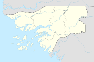
Guinea-Bissau, officially the Republic of Guinea-Bissau, is a country in West Africa that covers 36,125 square kilometres (13,948 sq mi) with an estimated population of 2,026,778. It borders Senegal to its north and Guinea to its southeast.
The region now known as Guinea-Bissau, in West Africa, has been inhabited by humans for thousands of years. During the 13th century CE, it was a province of the Mali Empire which later became independent as the empire of Kaabu. The Portuguese Empire claimed the region during the 1450s, but its control was limited to several forts along the coast during most of this period; it gained control of the mainland after a series of "pacification campaigns" from 1912 to 1915, which used military forces to violently crush local resistance. The offshore Bijagos Islands were not colonized until 1936. Guinea-Bissau gained independence from Portugal in 1974. The introduction of multi-party politics in 1991 led to the first multi-party elections in 1994. A civil war broke out in 1998, which lasted until the following year.

The economy of Guinea-Bissau comprises a mixture of state-owned and private companies. Guinea-Bissau is among the world's least developed nations and one of the 10 poorest countries in the world, and depends mainly on agriculture and fishing. Cashew crops have increased remarkably in recent years, and the country ranked ninth in cashew production for the year 2019.

Transport infrastructure in Guinea-Bissau is basic, with most roads outside the capital Bissau being unpaved.

The Revolutionary Armed Forces of the People is the national military of Guinea-Bissau. It consists of an army, a navy, an air force, and paramilitary forces. The World Bank estimated that there were around 4,000 personnel in the armed forces. The estimated military expenditure are $23.3 million, and military spending as a percentage of GDP is 1.7%.

Bissau is the capital and largest city of Guinea-Bissau. As of 2015, it had a population of 492,004. Bissau is located on the Geba River estuary, off the Atlantic Ocean, and is Guinea-Bissau's largest city, major port, its administrative and military center.

The Community of Portuguese Language Countries, also known as the Lusophone Community, is an international organization and political association of Lusophone nations across five continents, where Portuguese is an official language. The CPLP operates as a privileged, multilateral forum for the mutual cooperation of the governments, economies, non-governmental organizations, and peoples of the Lusofonia. The CPLP consists of 9 member states and 33 associate observers, located in Europe, South America, Asia, Africa and Oceania, totaling 38 countries and 4 organizations.

The Guinea-Bissau War of Independence, also known as the Bissau-Guinean War of Independence, was an armed independence conflict that took place in Portuguese Guinea from 1963 to 1974. It was fought between Portugal and the African Party for the Independence of Guinea and Cape Verde, an armed independence movement backed by Cuba, the Soviet Union, Yugoslavia and Brazil. The war is commonly referred to as "Portugal's Vietnam" because it was a protracted guerrilla war which had extremely high costs in men and material and which created significant internal political turmoil in Portugal.

Quinara is a region in central Guinea-Bissau and its capital is Fulacunda. There has not been any local administration since the civil war of 1998-99 and all the social services are done by organs of civil society and other government agencies. It is a coastal region covered with Mangrove swamps, rain forest and tangled forest and receives an annual rainfall of more than 1,000 mm (39 in).

The Portuguese Colonial War, also known in Portugal as the Overseas War or in the former colonies as the War of Liberation, and also known as the Angolan, Guinea-Bissau and Mozambican War of Independence, was a 13-year-long conflict fought between Portugal's military and the emerging nationalist movements in Portugal's African colonies between 1961 and 1974. The Portuguese regime at the time, the Estado Novo, was overthrown by a military coup in 1974, and the change in government brought the conflict to an end. The war was a decisive ideological struggle in Lusophone Africa, surrounding nations, and mainland Portugal.

Guinean Portuguese is the variety of Portuguese spoken in Guinea-Bissau, where it is the official language.

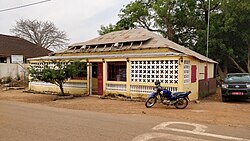
Empada is a town and a sector with the same name in the Quinara region of Guinea-Bissau. The city is located on the Buba river, the sector borders the Atlantic Ocean to the west.

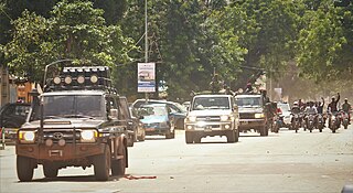
Presidential elections were held in Guinea-Bissau on 18 March 2012 following the death of President Malam Bacai Sanhá on 9 January. A run-off was set to be held on 29 April after being postponed by a week as announced by electoral commission chief Desejado Lima Dacosta. However, after a military coup, the leading candidates were arrested and the election was cancelled. The junta's spokesman then announced plans to hold an election in two years, despite condemnation. General elections were subsequently held in April 2014.

On 12 April 2012, a coup d'état in Guinea-Bissau was staged by elements of the armed forces about two weeks before the second round of a presidential election between Carlos Gomes Júnior and Kumba Ialá. The coup started in the evening with military personnel and equipment making its way onto the streets, followed by the state-owned media being taken off-air.

José Mário Vaz is a Bissau-Guinean politician who served as president of Guinea-Bissau from 23 June 2014 to 27 February 2020.
Bissau is a city in Guinea-Bissau, a country in West Africa, formerly part of the kingdom of Kaabu and part of the Mali Empire.

Bolama is the closest of the Bissagos Islands to the mainland of Guinea-Bissau. The island has a population of 6,024. It shares its name with its largest settlement, the town Bolama, which is the capital of the island and the Bolama Region. A causeway links the island to the Ilha das Cobras. Attractions on the island include sandy beaches and the abandoned ruins of the town of Bolama. It is known for its cashew nuts.
On 5 September 2021, President of Guinea Alpha Condé was captured by the country's armed forces in a coup d'état after gunfire in the capital, Conakry. Special forces commander Mamady Doumbouya released a broadcast on state television announcing the dissolution of the constitution and government.
Guinala or Quinara was an important Biafada kingdom in pre-colonial Guinea-Bissau situated between the Geba and Rio Grande de Buba rivers. The main port town, also called Guinala, was located on a tributary of the Buba, with the capital Bruco a short distance inland.