The Šumadija District is one of eight administrative districts of Šumadija and Western Serbia. It is located in the central parts of the country. According to the 2011 census results, it has a population of 293,308 inhabitants, and the administrative center is the city of Kragujevac. The district is named after the geographical region of Šumadija.

The Nišava District is one of nine administrative districts of Southern and Eastern Serbia. It expands to the south-eastern parts of Serbia. According to the 2011 census results, it has a population of 372,404 inhabitants. The administrative center of the district is the city of Niš.

Voždovac is a municipality of the city of Belgrade. According to the 2011 census results, the municipality has a population of 158,213 inhabitants.

Veternik is a suburban settlement of the city of Novi Sad, Serbia. Its population numbers 17,454 and most of its inhabitants are ethnic Serbs. Over the years, especially in the 1990s, it grew with size and inhabitants thus merging with Futog to the west and Novi Sad to the east.

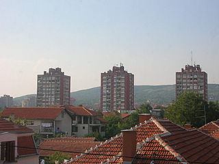
Palilula is one of five city municipalities which constitute the city of Niš. It has a population of 71,707 inhabitants. It was formed on 6 June 2002.

Crveni Krst is one of five city municipalities which constitute the city of Niš. The municipality has a population of 31,762 inhabitants.
Pantelej is one of five city municipalities which constitute the city of Niš. The municipality has a population of 79,290 inhabitants, according to the 2011 census results.
Bubanj Potok is a non-residential suburban settlement of Belgrade, the capital of Serbia. It is located in Belgrade's municipality of Voždovac.

The Crveni Krst concentration camp, located in Crveni Krst, Niš, was operated by the German Gestapo and used to hold captured Serbs, Jews and Romanis during the Second World War. Established in mid-1941, it was used to detain as many as 35,000 people during the war and was liberated by the Yugoslav Partisans in 1944. More than 10,000 people are thought to have been killed at the camp. After the war, a memorial to the victims of the camp was erected on Mount Bubanj, where many inmates were shot. A memorial museum was opened on the former campgrounds in 1967 and in 1979 the campgrounds were declared a Cultural Monument of Exceptional Importance and came under the protection of the Socialist Republic of Serbia.

Despotovo is a village located in the Bačka Palanka municipality, in the South Bačka District of Serbia. It is situated in the autonomous province of Vojvodina. Despotovo had a total population of 2,081 inhabitants in 1991 and 2,096 in 2002. Most of the inhabitants of the village are ethnic Serbs.

Prebilovci is a village in Bosnia and Herzegovina, near the city of Čapljina (Чапљина). Prebilovci was first mentioned in the 15th century. The village has a population of roughly around 50 inhabitants.

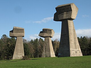
Memorial Park Bubanj is a World War II memorial complex built to commemorate the shooting and execution of more than 10,000 citizens of Niš and people from Serbia and other parts of the country, but according to some data, over 12,000 people, and it is located in Palilula municipality of Niš, Serbia.
Berbatovo is an inhabited settlement in Palilula in Nis region in Nisava district. It is located on the southern edge of Nis valley, at the foot of the mountain SELIČEVICA, 10 km from the center of Nis. In 1878 had 45 households and 375 residents, and 1930 132 households and 687 inhabitants. According to the census of 2002, there were 364 people.
Berčinac is an inhabited settlement in Serbia in the city of Nisavski. It is located in southeastern Europe, 12 km northwest from the city of Niš. According to the census of 2002, there were 129 people .>
Donji Komren is a suburb of Nis in Nisava district, in south-eastern Serbia. Administratively part of the city municipality of the Red Cross. It is located about 4 km north of the city center. According to the census of 2002, there were 5725 people.
Gornji Komren inhabited settlement in the city municipality of the Red Cross in the area of the city of Nis in Nisava district. Located at the foot of the hill Winnick, about 5 km from the center of Nis. According to the census of 2002, there were 946 people.
Lalinac is a village situated in the city municipality of Palilula in the Nisava district of the city Niš, Serbia. It is located on the alluvial terrace of South Morava and Nisava, about 10 km west of the center of Nis. According to the 2002 census, there were 1828 inhabitants. municipality in Serbia.
Beloinje is a village in Serbia, in the municipality of Svrljig in Nisava district. According to the census of 2002, there were 343 people.
Prosek is a village in the municipality of Niška Banja, within the city of Niš, Serbia. According to the 2002 census, the village had 600 inhabitants.