
Chittoor district is one of the eight districts in the Rayalaseema region of the Indian state of Andhra Pradesh. It has a population of 18,72,951 according to 2011 census of India. It is a major market centre for mangoes, grains, sugarcane, and peanuts. The district headquarters is located at Chittoor.

Srikalahasti is a holy town in Tirupati district of the Indian state of Andhra Pradesh. It is a municipality and the revenue division of Srikalahasti mandal and Srikalahasti revenue division. It is a part of the Tirupati Urban Development Authority, which is located on the banks of the River Swarnamukhi.
Tirupati (rural) mandal is one of the 34 mandals in Tirupati district of Andhra Pradesh in India. It is under the administration of Tirupati revenue division and the headquarters are located at Tirupati.
Santhipuram mandal is one of the 66 mandals in Chittoor district of the Indian state of Andhra Pradesh. The headquarters are located at Arimuthanapalle. The mandal is bounded by Ramakuppam, Kuppam and Gudupalle mandals..This mandal is under Kuppam Revenue Division.
Tirupati (urban) mandal is one of the 34 mandals in Tirupati district of the Indian state of Andhra Pradesh. It has its headquarters at Tirupati city&Tirupati district. The mandal is bounded by Chandragiri, Tirupati (rural) mandals. A part of it also borders Annamayya district.

Gajulamandyam is a neighbourhood and suburb of Tirupati. It is located in Tirupati district of the Indian state of Andhra Pradesh. It falls in the jurisdictional limit of Tirupati Urban Development Authority. It is a part of Tirupati urban agglomeration and located in Renigunta mandal of Tirupati revenue division.
Renigunta mandal is one of the 34 mandals in Tirupati district of the Indian state of Andhra Pradesh. Its headquarters are located at Renigunta, suburb of Tirupati.. The mandal is bounded by Tirupati (urban), Tirupati (rural), Vadamalapeta, Yerpedu.This mandal is located at Srikalahasti revenue division.
Gudur mandal is one of the 34 mandals in Tirupati district of the state of Andhra Pradesh, India. Its headquarters are located at Gudur. The mandal is situated on the coast of Bay of Bengal, bounded by Sydapuram, Manubolu, Balayapalle, Ojili and Chillakur mandals. It is a part of Gudur revenue division.
Kota mandal is one of the 34 mandals in Tirupati district of the state of Andhra Pradesh in India. Its headquarters are located at Kota. The mandal is bounded by Muthukur mandal, Chillakur, Ojili, Chittamur, Vakadu mandals and it also borders Nellore district.
Pulicherla mandal is one of the 66 mandals in Chittoor district of the Indian state of Andhra Pradesh.
Chandragiri mandal is one of the 34 mandals in Tirupati district of the Indian state of Andhra Pradesh. It is under the administration of Tirupati revenue division and the headquarters are located at Chandragiri.
Srikalahasti mandal is one of the 34 mandals in Tirupati district of the Indian state of Andhra Pradesh. It is under the administration of Srikalahasti revenue division and the headquarters are located at Srikalahasti. The mandal is bounded by Renigunta, Yerpedu, Narayanavanam and Thottambedu.
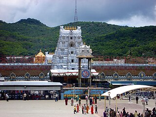
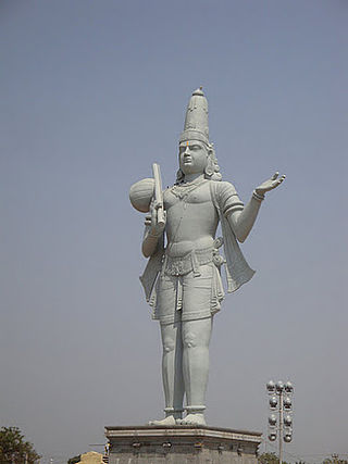
Tirupati district is one of the eight districts of Rayalaseema region in the Indian state of Andhra Pradesh. The district headquarters is located at Tirupati city. This district is known for its numerous historic temples, including the Hindu shrine of Tirumala Venkateswara Temple and Sri Kalahasteeswara temple. The district is also home to Satish Dhawan Space Centre, a rocket launch centre located in Sriharikota. The river Swarnamukhi flows through Tirupati, Srikalahasti and joins the Bay of Bengal.
Annamayya district is one of the eight districts in the Rayalaseema region of Andhra Pradesh, established in 2022. Rayachoti is the district administrative headquarters and Madanapalle is the most populated town in the district.
Pakala mandal is one of the 34 mandals in Tirupati district of the Indian state of Andhra Pradesh. It is under the administration of Tirupati revenue division and the headquarters are located at Pakala.
Venkatagiri mandal is one of the 34 mandals in Tirupati district in the Indian state of Andhra Pradesh. It is a part of Gudur revenue division.
Lingasamudram mandal is one of the 38 mandals in Nellore district of the Indian state of Andhra Pradesh. Its headquarters are located at Lingasamudram. The mandal is bounded by .This mandal is located at Kandukur revenue division.
Chittamur mandal is one of the 34 mandals in Tirupati district in the Indian state of Andhra Pradesh. It is a part of Gudur revenue division with its headquarters at Chittamur.
Narayanavanam mandal is one of the 34 mandals in Tirupati district in the Indian state of Andhra Pradesh. It is administered as a part of Srikalahasti revenue division.
Chinnagottigallu mandal is one of the 34 mandals in Tirupati district in the Indian state of Andhra Pradesh. It is a part of Tirupati revenue division with its headquarters at Chinnagottigallu.

