Olympic National Forest is a U.S. National Forest located in Washington, USA. With an area of 628,115 acres (254,189 ha), it nearly surrounds Olympic National Park and the Olympic Mountain range. Olympic National Forest contains parts of Clallam, Grays Harbor, Jefferson, and Mason counties. The landscape of the national forest varies, from the temperate Olympic rain forest to the salt water fjord of Hood Canal to the peaks of Mt. Washington.

Mount Washington is a 6,260-foot-tall (1,910 m) peak in the Olympic Mountains of Washington state. The mountain is located in the Mount Skokomish Wilderness.

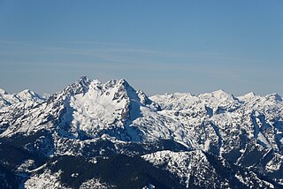
Mount Constance is a peak in the Olympic Mountains of Washington and the third highest in the range. It is the most visually prominent peak on Seattle's western skyline. Despite being almost as tall as the ice-clad Mount Olympus to the west, Mount Constance has little in the way of glaciers and permanent snow because the eastern, and particularly this northeastern, portion of the Olympics receives far less precipitation. However the narrow and steep Crystal Glacier still exists on the mountain's north face, shaded by the bulk of the main peak and with a small lake at its terminus. In addition, the treeline is higher here than mountains to the west, also hinting at the drier alpine conditions.

Mount Olympus, at 7,980 feet (2,430 m), is the tallest and most prominent mountain in the Olympic Mountains of the U.S. state of Washington. Located on the Olympic Peninsula, it is also a central feature of Olympic National Park. Mount Olympus is the highest summit of the Olympic Mountains; however, peaks such as Mount Constance and The Brothers, on the eastern margin of the range, are better known, being visible from the Seattle metropolitan area.

Mount San Antonio, commonly referred to as Mount Baldy or Old Baldy, is a 10,064 ft (3,068 m) summit in the San Gabriel Mountains on the border of Los Angeles and San Bernardino counties of California. Lying within the San Gabriel Mountains National Monument and Angeles National Forest, it is the highest point within the mountain range, the County of Los Angeles, and the Los Angeles metropolitan area.
Colonel Bob Wilderness is a 11,855-acre (4,798 ha) protected area located in the southwest corner of Olympic National Forest in the state of Washington. It is named after 19th-century orator Robert Green Ingersoll. Lake Quinault lies about 15 miles to the west. Elevations in the wilderness vary from 300 to 4,509 feet above sea level. The highest elevation is an unnamed peak; the second-highest elevation is Colonel Bob Mountain at 4,492 feet. The wilderness is a temperate rain forest with annual rainfall greater than 150 inches (3,800 mm).

The Buckhorn Wilderness is a 44,319-acre (17,935 ha) mountainous wilderness area on the northeastern Olympic Peninsula in Washington, USA. Named after Buckhorn Mountain, the wilderness abuts the eastern boundary of Olympic National Park which includes nearby Mount Constance, Inner Constance, Warrior Peak, and Mount Deception.
The Brothers Wilderness is a designated wilderness area located in the Olympic National Forest on the eastern side of the Olympic Peninsula south of Buckhorn Wilderness and north of Mount Skokomish Wilderness. The wilderness area comprises 16,337 acres (6,611 ha) administered by the U.S. Forest Service. The wilderness is named after The Brothers peaks, which are the tallest in the wilderness area at 6,866 feet (2,093 m). The Duckabush River flows through the middle of the area. The area lies in the rain shadow of the Olympic Mountains, receiving about 80 inches (2,000 mm) of annual precipitation.
Wonder Mountain Wilderness is a designated wilderness area encompassing Wonder Mountain in the Olympic National Forest on the Olympic Peninsula of Washington in the United States. The wilderness comprises 2,349 acres (951 ha) bordering Olympic National Park and administered by the U.S. Forest Service.

Mount Skokomish Wilderness is a designated wilderness area in the southeast portion of Olympic National Forest on the Olympic Peninsula of Washington in the United States. The wilderness area comprises 13,291 acres (5,379 ha) administered by the U.S. Forest Service.
Marmot Pass, at 6,231 feet (1,899 m)-high, provides a trail corridor through the Buckhorn Wilderness in the Olympic Mountains of Washington state. The pass is situated near Buckhorn Mountain, Iron Mountain, and Boulder Ridge. From Marmot Pass, one can see the tallest peaks in the mountain range, and look down at the Dungeness Valley, and Hood Canal. And it's been said Seattle fireworks are visible from the pass on the 4th of July.

Castle Peak is a mountain in the western United States, the highest peak in the White Cloud Mountains of central Idaho and the Idaho Batholith. Located in Custer County, it is the 25th highest peak in the state, and the ninth most prominent.
Larch Mountain is a 2,664-foot (812 m) summit in the Black Hills range of Thurston County, Washington state. It is one of the two highest peaks in the Black Hills, along with Capitol Peak, and preceding 2,356-foot (718 m) Rock Candy Mountain. It is the most prominent peak in Thurston County.

Mount Townsend is a mountain in the U.S state of Washington located within the Buckhorn Wilderness near Quilcene.

Mount Fricaba is a 7,139-foot-elevation (2,176 m) double summit mountain located in the Olympic Mountains, in Jefferson County of Washington state. It is situated on the shared border of Olympic National Park with Buckhorn Wilderness, and is the highest point in that wilderness, as well as the Olympic National Forest. Its nearest higher peak is Hal Foss Peak, 0.74 miles (1.19 km) to the southwest. Precipitation runoff from the peak drains east into headwaters of the Dungeness River, or west into Deception Creek which is a tributary of the Dosewallips River. The mountain's name was officially adopted in 1961 by the United States Board on Geographic Names based on usage by The Mountaineers since 1907, and inclusion in Fred Beckey's "Climber's Guide to the Cascade and Olympic Mountains of Washington" published in 1949. The first ascent of the mountain was made in 1957 by Don Bechlem and Jack Newman.

Boulder Ridge is a 6,852-foot (2,088-metre) elevation mountain ridge located in the eastern Olympic Mountains in Jefferson County of Washington state. It is set within Buckhorn Wilderness on land managed by the Olympic National Forest. The nearest higher neighbor is Alphabet Ridge, 0.94 mi (1.51 km) to the south, and Buckhorn Mountain rises 1.3 mi (2.1 km) to the north. Precipitation runoff from Boulder Ridge drains east into headwaters of the Big Quilcene River, west into tributaries of Dungeness River, and south into Charlia Lakes, thence Tunnel Creek.
Mount Worthington is a 6,938-foot (2,115-metre) elevation double-summit mountain located in the eastern Olympic Mountains in Jefferson County of Washington state. It is set within Buckhorn Wilderness, on land managed by the Olympic National Forest. The nearest neighbor is Iron Mountain, 0.76 mi (1.22 km) to the southwest, and the nearest higher peak is Buckhorn Mountain, 1.3 mi (2.1 km) to the southwest. Precipitation runoff from Mount Worthington drains south into the Big Quilcene River, or north into Copper Creek which is a tributary of the Dungeness River. This mountain was first known as Copper Peak, but was renamed by Jack Christensen for the William J. Worthington family, pioneers of nearby Quilcene. Copper was mined in the Tubal Cain mine at the northern base of this mountain in the early 1900s. In the same vicinity of the abandoned mine are the remains of a modified B-17 plane that crashed on January 19, 1952, when returning from a search-and-rescue mission.

Tyler Peak is a 6,364 feet (1,940 m) mountain summit located in Clallam County of Washington state, United States. It is situated in the northeastern Olympic Mountains, near the northern end of Gray Wolf Ridge, and is set within Buckhorn Wilderness, on land managed by the Olympic National Forest. The next highest neighbor is Mt. Baldy, two miles to the west.

Petunia Peak is a 6,953-foot (2,119-metre) mountain summit located in Jefferson County of Washington state.

Iron Mountain is a 6,826-foot (2,081-metre) elevation summit located in the eastern Olympic Mountains in Jefferson County of Washington state. It is set within Buckhorn Wilderness, on land managed by Olympic National Forest. It is situated between Buckhorn Mountain, 0.58 mi (0.93 km) to the southwest, and Mount Worthington, 0.76 mi (1.22 km) to the northeast. Precipitation runoff from Iron Mountain drains south into the Big Quilcene River, and north into Copper Creek which is a tributary of the Dungeness River. Topographic relief is significant as the southeast aspect rises 2,800 feet above the Big Quilcene River in less than one mile, and the north aspect rises 1,700 feet above Buckhorn Lake in one-half mile. Old-growth forests of Douglas fir, western hemlock, and western redcedar grow in the valleys surrounding the peak. The nearest community is Quilcene 11 miles to the east.


