
The Central Valley is a broad, elongated, flat valley that dominates the interior of California. It is 40–60 mi (60–100 km) wide and runs approximately 450 mi (720 km) from north-northwest to south-southeast, inland from and parallel to the Pacific coast of the state. It covers approximately 18,000 sq mi (47,000 km2), about 11% of California's land area. The valley is bounded by the Coast Ranges to the west and the Sierra Nevada to the east.

The San Joaquin Valley is the southern half of California's Central Valley, an area drained by the San Joaquin River. Praised as a breadbasket, the San Joaquin Valley is a major source of food, producing a significant part of California's agricultural output.

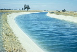
The Governor Edmund G. Brown California Aqueduct is a system of canals, tunnels, and pipelines that conveys water collected from the Sierra Nevada Mountains and valleys of Northern and Central California to Southern California. Named after California Governor Edmund Gerald "Pat" Brown Sr., the over 400-mile (640 km) aqueduct is the principal feature of the California State Water Project.

The Kern River, previously Rio de San Felipe, later La Porciuncula, is an Endangered, Wild and Scenic river in the U.S. state of California, approximately 165 miles (270 km) long. It drains an area of the southern Sierra Nevada mountains northeast of Bakersfield. Fed by snowmelt near Mount Whitney, the river passes through scenic canyons in the mountains and is a popular destination for whitewater rafting and kayaking. It is the southernmost major river system in the Sierra Nevada, and is the only major river in the Sierra that drains in a southerly direction.

Pyramid Lake is a reservoir formed by Pyramid Dam on Piru Creek in the eastern San Emigdio Mountains, near Castaic, Southern California. It is a part of the West Branch California Aqueduct, which is a part of the California State Water Project. Its water is fed by the system after being pumped up from the San Joaquin Valley and through the Tehachapi Mountains.
The Delta–Mendota Canal is a 117-mile-long (188 km) aqueduct in central California, United States. The canal was designed and completed in 1951 by the U.S. Bureau of Reclamation as part of the Central Valley Project. It carries freshwater to replace San Joaquin River water which is diverted into the Madera Canal and Friant-Kern Canal at Friant Dam.

Castaic Dam is an embankment dam in northwestern Los Angeles County, California, in the unincorporated area of Castaic. Although located on Castaic Creek, a major tributary of the Santa Clara River, Castaic Creek provides little of its water. The lake is the terminus of the West Branch of the California Aqueduct, part of the State Water Project. The dam was built by the California Department of Water Resources and construction was completed in 1973. The lake has a capacity of 325,000 acre-feet (401,000,000 m3) and stores drinking water for the western portion of the Greater Los Angeles Area.

San Luis Dam is a major earth-filled dam in Merced County, California, which forms San Luis Reservoir, the largest off-stream reservoir in the United States. The dam and reservoir are located in the Diablo Range to the east of Pacheco Pass and about 10 miles (16 km) west of Los Banos. San Luis Dam, a jointly-owned state and federal facility, stores more than 2 million acre feet (2.5 km3) of water for the California State Water Project and the federal Central Valley Project. Although the dam is located in the valley of San Luis Creek, the majority of its water comes from man-made aqueducts which are supplied from other rivers in Northern California.

The California Department of Water Resources (DWR) is part of the California Natural Resources Agency and is responsible for the management and regulation of the State of California's water usage. The department was created in 1956 by Governor Goodwin Knight following severe flooding across Northern California in 1955, where they combined the Division of Water Resources of the Department of Public Works with the State Engineer's Office, the Water Project Authority, and the State Water Resources Board. It is headquartered in Sacramento.

The California State Water Project, commonly known as the SWP, is a state water management project in the U.S. state of California under the supervision of the California Department of Water Resources. The SWP is one of the largest public water and power utilities in the world, providing drinking water for more than 27 million people and generating an average of 6,500 GWh of hydroelectricity annually. However, as it is the largest single consumer of power in the state itself, it has a net usage of 5,100 GWh.

The North Bay Aqueduct (NBA) is part of the California State Water Project that was built in two phases, Phase I (1967-168) and Phase II (1985-1988). The aqueduct is 27.4 miles (44.1 km) long all in pipelines and serves Napa and Solano counties, California. The aqueduct provides water to about 500,000 residents in Solano and Napa.
Harvey Oren Banks was an American civil engineer who was appointed State Engineer of California in 1955 and the first Director of the California Department of Water Resources (DWR) in 1956. Under his direction, DWR completed its first California Water Plan and initiated the first stage of planning of the California State Water Project (SWP). It was under his term as Director that the California Legislature adopted the Burns-Porter Act authorizing the construction of the SWP in 1959. In 1961 voters approved massive bonds to pay for the construction of the SWP. Banks left the public sector that same year to return to the private sector, where he worked as a consulting engineer until his death in 1996. Banks' papers (1940-1995) are held at the Water Resources Collections and Archives, University of California, Riverside.
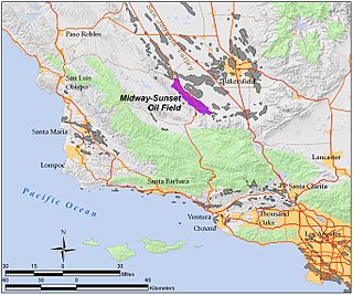
The Midway-Sunset Oil Field is a large oil field in Kern County, San Joaquin Valley, California in the United States. It is the largest known oilfield in California and the third largest in the United States.

The Friant-Kern Canal is a 152 mi (245 km) aqueduct managed by the United States Bureau of Reclamation in Central California to convey water to augment irrigation capacity in Fresno, Tulare, and Kern counties. A part of the Central Valley Project, canal construction began in 1949 and was completed in 1951 at a cost of $60.8 million.
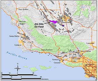
The Elk Hills Oil Field is a large oil field in western Kern County, in the Elk Hills of the San Joaquin Valley, California in the United States, about 20 miles (32 km) west of Bakersfield. Discovered in 1911, and having a cumulative production of close to 1.3 billion barrels (210,000 dam3) of oil at the end of 2006, it is the fifth-largest oil field in California, and the seventh-most productive field in the United States.

The Buena Vista Oil Field, formerly the Naval Petroleum Reserve No. 2 (NPR-2) is a large oil field in Kern County, San Joaquin Valley, California in the United States. Discovered in 1909, and having a cumulative production of approximately 667 million barrels (106,000,000 m3), it is the tenth-largest oil field in California. As of year end 2006 the field had a total reserve of only about one percent of its original oil, and having produced a mere 713,000 barrels (113,400 m3). Since, the field has gone through a revitalization. Crimson Resources initiated a waterflood in the Etchegoin Formation, saw good response and sold the asset to Occidental Petroleum. CRC continued the development of the waterflood, but also tested the viability of the Monterey Formation. The Monterey Formation at Buena Vista has proven to be a viable target and is currently being developed.

The Dos Amigos Pumping Plant is a water pumping plant, constructed between 1963 and 1966 as part of the California State Water Project. It is able to withhold and transport water between Northern and Southern California through an approximately 444 mile aqueduct. It is located in Central California's San Joaquin Valley along Interstate 5, about 10 miles south of Los Banos in Merced County.
Connecting Slough, the former slough between Kern Lake and Buena Vista Lake in the southeastern San Joaquin Valley, in Kern County, California.

Buena Vista Slough was the joint outlet of an overflowing Buena Vista Lake and a distributary of the Kern River into Tulare Lake. It is now diverted into a system of canals by the Outlet Canal of the Central Valley Project.
The Los Banos Grandes reservoir was first proposed in 1983 and would have served a similar purpose to Sites Reservoir. The 1.73 million acre-feet (2.13 km3) reservoir would have been located along the California Aqueduct several miles south of San Luis Reservoir, and would have allowed for the storage of water during wet years when extra water could be pumped from the Sacramento–San Joaquin Delta. Pumped-storage hydroelectric plants would have been built between Los Banos Grandes and the existing Los Banos flood control reservoir, and between that reservoir and the aqueduct. The current status of Los Banos Grandes remains uncertain, as the DWR has been unable to appropriate funding since the 1990s.