The Los Angeles Aqueduct system, comprising the Los Angeles Aqueduct and the Second Los Angeles Aqueduct, is a water conveyance system, built and operated by the Los Angeles Department of Water and Power. The Owens Valley aqueduct was designed and built by the city's water department, at the time named The Bureau of Los Angeles Aqueduct, under the supervision of the department's Chief Engineer William Mulholland. The system delivers water from the Owens River in the Eastern Sierra Nevada Mountains to Los Angeles, California.

The Governor Edmund G. Brown California Aqueduct is a system of canals, tunnels, and pipelines that conveys water collected from the Sierra Nevada Mountains and valleys of Northern and Central California to Southern California. Named after California Governor Edmund Gerald "Pat" Brown Sr., the over 400-mile (640 km) aqueduct is the principal feature of the California State Water Project.
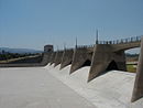
Pyramid Dam is a dam on Piru Creek located in northern Los Angeles County, north of Castaic and south of Gorman. Its reservoir, Pyramid Lake, stores water from the West Branch California Aqueduct for Ventura County and Los Angeles County. They are smaller than Castaic Dam and Lake, the other artificial water storage facility in the area, 7 miles (11 km) to the south.

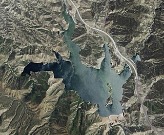
Pyramid Lake is a reservoir formed by Pyramid Dam on Piru Creek in the eastern San Emigdio Mountains, near Castaic, Southern California. It is a part of the West Branch California Aqueduct, which is a part of the California State Water Project. Its water is fed by the system after being pumped up from the San Joaquin Valley and through the Tehachapi Mountains.

Oroville Dam is an earthfill embankment dam on the Feather River east of the city of Oroville, California, in the Sierra Nevada foothills east of the Sacramento Valley. At 770 feet (235 m) high, it is the tallest dam in the U.S. and serves mainly for water supply, hydroelectricity generation, and flood control. The dam impounds Lake Oroville, the second-largest reservoir in California, capable of storing more than 3.5×10^6 acre⋅ft.

The Metropolitan Water District of Southern California is a regional wholesaler and the largest supplier of treated water in the United States. The name is usually shortened to "Met," "Metropolitan," or "MWD." It is a cooperative of fourteen cities, eleven municipal water districts, and one county water authority, that provides water to 19 million people in a 5,200-square-mile (13,000 km2) service area. It was created by an act of the California Legislature in 1928, primarily to build and operate the Colorado River Aqueduct. Metropolitan became the first contractor to the State Water Project in 1960.
The South Bay Aqueduct is an aqueduct located in the eastern part of the San Francisco Bay Area. It conveys water from the Sacramento-San Joaquin Delta through over forty miles of pipelines and canals. It begins in north-eastern Alameda County on the California Aqueduct's Bethany Reservoir serving as the forebay. The aqueduct flows along the eastern and southern edges of the Livermore Valley. Then it flows through a series of tunnels to an end in the foothills of eastern San Jose, 5 miles (8 km) from downtown San Jose, California.

Castaic Dam is an embankment dam in northwestern Los Angeles County, California, in the unincorporated area of Castaic. Although located on Castaic Creek, a major tributary of the Santa Clara River, Castaic Creek provides little of its water. The lake is the terminus of the West Branch of the California Aqueduct, part of the State Water Project. The dam was built by the California Department of Water Resources and construction was completed in 1973. The lake has a capacity of 325,000 acre-feet (401,000,000 m3) and stores drinking water for the western portion of the Greater Los Angeles Area.

San Luis Dam is a major earth-filled dam in Merced County, California, which forms San Luis Reservoir, the largest off-stream reservoir in the United States. The dam and reservoir are located in the Diablo Range to the east of Pacheco Pass and about 10 miles (16 km) west of Los Banos. San Luis Dam, a jointly-owned state and federal facility, stores more than 2 million acre feet (2.5 km3) of water for the California State Water Project and the federal Central Valley Project. Although the dam is located in the valley of San Luis Creek, the majority of its water comes from man-made aqueducts which are supplied from other rivers in Northern California.

The California Department of Water Resources (DWR) is part of the California Natural Resources Agency and is responsible for the management and regulation of the State of California's water usage. The department was created in 1956 by Governor Goodwin Knight following severe flooding across Northern California in 1955, where they combined the Division of Water Resources of the Department of Public Works with the State Engineer's Office, the Water Project Authority, and the State Water Resources Board. It is headquartered in Sacramento.

The San Luis Reservoir is an artificial lake on San Luis Creek in the eastern slopes of the Diablo Range of Merced County, California, approximately 12 mi (19 km) west of Los Banos on State Route 152, which crosses Pacheco Pass and runs along its north shore. It is the fifth largest reservoir in California. The reservoir stores water taken from the San Joaquin-Sacramento River Delta. Water is pumped uphill into the reservoir from the O'Neill Forebay which is fed by the California Aqueduct and is released back into the forebay to continue downstream along the aqueduct as needed for farm irrigation and other uses. Depending on water levels, the reservoir is approximately nine miles long from north to south at its longest point, and five miles (8 km) wide. At the eastern end of the reservoir is the San Luis Dam, or the B.F. Sisk Dam, the fourth largest embankment dam in the United States, which allows for a total capacity of 2,041,000 acre-feet (2,518,000 dam3). Pacheco State Park lies along its western shores.

The California State Water Project, commonly known as the SWP, is a state water management project in the U.S. state of California under the supervision of the California Department of Water Resources. The SWP is one of the largest public water and power utilities in the world, providing drinking water for more than 23 million people and generating an average of 6,500 GWh of hydroelectricity annually. However, as it is the largest single consumer of power in the state itself, it has a net usage of 5,100 GWh.

Castaic Creek is a 25.0-mile-long (40.2 km) stream in the Sierra Pelona Mountains, in northeastern Los Angeles County, California. It is a tributary of the Santa Clara River.

Castaic Lake is a reservoir formed by Castaic Dam on Castaic Creek, in the Sierra Pelona Mountains of northwestern Los Angeles County, California, United States, near the town of Castaic.

The Oroville–Thermalito Complex is a group of reservoirs, structures, and facilities located in and around the city of Oroville in Butte County, California. The complex serves not only as a regional water conveyance and storage system, but is the headwaters for, and therefore perhaps is the most vital part of, the California Department of Water Resources' State Water Project, as one the largest publicly built and operated water and power development and conveyance systems.

Castaic Power Plant, also known as the Castaic Pumped-Storage Plant, is a seven unit pumped-storage hydroelectric plant, operated by the Los Angeles Department of Water and Power, which provides peak load power from the falling water on the West Branch of the California State Aqueduct. It is a cooperative venture between the LADWP and the Department of Water Resources of the State of California. An agreement between the two organizations was signed on September 2, 1966, for construction of the project.

The Big Creek Hydroelectric Project is an extensive hydroelectric power scheme on the upper San Joaquin River system, in the Sierra Nevada of central California. The project is owned and operated by Southern California Edison (SCE). The use and reuse of the waters of the San Joaquin River, its South Fork, and the namesake of the project, Big Creek – over a vertical drop of 6,200 ft (1,900 m) – have over the years inspired a nickname, "The Hardest Working Water in the World".
Elderberry Forebay Dam is a dam located in the Sierra Pelona Mountains of northwestern Los Angeles County, California. The dam partitions Elderberry Forebay from Castaic Lake. It forms the headwater reservoir for Castaic Power Plant, a pumped-storage hydroelectricity generation facility. The dam was completed in 1974 as part of the California State Water Project.
The Angeles Tunnel is a 7.2-mile-long (11.6 km), 30-foot-diameter (9.1 m) water tunnel located in the Sierra Pelona Mountains in Los Angeles County, California, about 50 miles (80 km) north of Los Angeles. It was constructed between 1967 and 1970 as part of the California State Water Project and serves as the final leg of the west branch of the California Aqueduct, which carries Northern California water to Southern California residents.
Castac or Castaic is an unincorporated, rural community near the city of Santa Clarita in Southern California. It can also refer to: