Sepulveda Dam, along with Hansen Dam located in the north San Fernando Valley, was constructed in response to the historic 1938 floods which killed 144 people. The dam's 17,300-acre-foot (21,300,000m3) capacity would allow it to hold back roughly 2+1⁄4 inches (57mm) of runoff from the 141 square miles (370km2) of catchment upstream. It was placed at what was the then-current edge of the city. East of the dam, the river was crowded into a narrow channel by the city's growth. The Sepulveda Flood Control Basin is a large and undeveloped area in the center of the Valley, used mostly for wildlife refuge and recreation. After the 1938 Los Angeles River flood, the channelization of all the Valley's dry washes was created with dry, concrete-lined river bottoms. Currently these are being devolved in part as interconnecting bike paths.[2]
Behind the dam, the Sepulveda Basin is home to several large recreation areas including Woodley Park, a model aircraft field, The Japanese Garden, a wildlife refuge,[3] a water reclamation plant, and an armory. The facilities are compatible with occasional inundation from reservoir impoundment.[4]
History
Looking upstream in the outlet channel. Form work has been stripped from the outlet control tower and service bridge and one of the outlet control slide gate frames is being lowered into position for installation.Westerly view along the top of the spillway showing the completed service bridge and handrails.
When the 1914 flood caused $10 million in damages to the developing basin areas, a public outcry began for action to address the recurring flooding problems. During the following year, the Los Angeles County Flood Control District was formed. Some of the early flood control efforts included smaller areas of channelization and the planning for needed reservoirs. Taxpayers approved bond issues in 1917 and 1924 to build the first major dams. However, they were not willing to provide enough funding for the much needed and substantial infrastructure downstream of these dams. After two more destructive floods in the 1930s, most notably the 1938 flood, federal assistance was requested. The Army Corps of Engineers took a lead role in channelizing the river and constructing several dams which would create flood control basins behind them. Channelization began in 1938, and by 1960 the project was completed to form the present 51-mile (82km) engineered waterway. Included in this work were Hansen Dam, completed in 1940 and followed by Sepulveda Dam in 1941.[5] In 1973, Burbank Boulevard was built through the Sepulveda Basin, and Woodley Ave was also built in the recreation area in 1975.
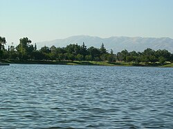
Lake Balboa Park, also known as Anthony C. Beilenson Park, is an 80-acre (32ha) park and water recreation facility with boat rentals and fishing. Lake Balboa is a 27-acre (11ha) lake filled with water reclaimed from the Tillman Water Reclamation Plant.[12][13] It also has barbecue pits, children's play area, picnic tables, and covered picnic pavilions.[12] There are many Flowering cherry trees (Prunus serrulata 'Pink Cloud') in the park.[14]
The Balboa Station on the G Line is located at the north end of the park, at Balboa Boulevard.
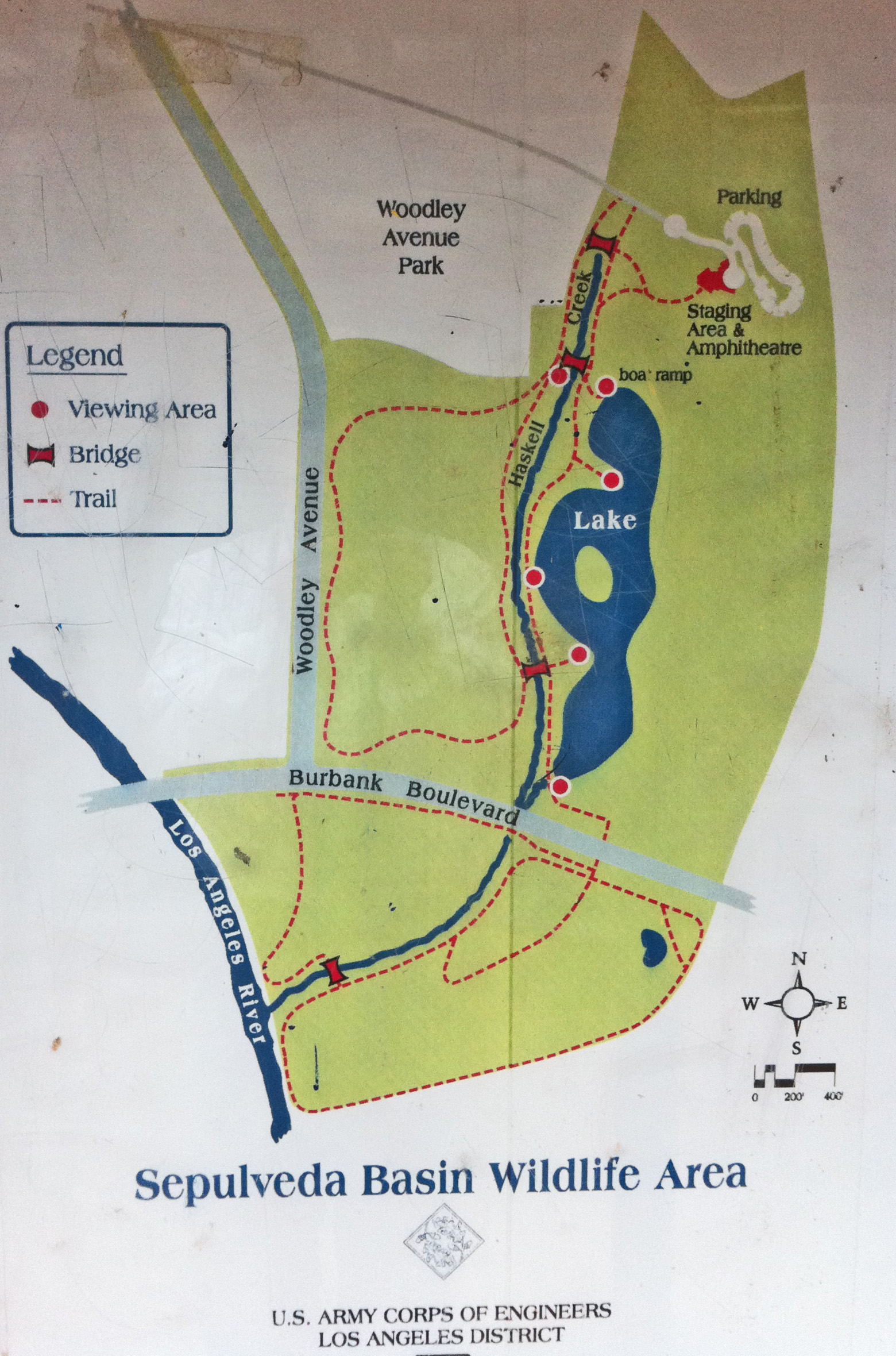
Sepulveda Basin Wildlife Reserve
The Sepulveda Basin Wildlife Reserve is at the southeast end of the Sepulveda Flood Control Basin and Recreation Area.[15] It has two sections, the North Reserve and South Reserve, located north and south of Burbank Boulevard.[16][17] Both have nature paths and hiking trails.[15][18] Access and parking are in eastern Woodley Park near to the Tillman Water Reclamation Plant, or from Burbank Boulevard east of Woodley Avenue.[18]
The Sepulveda Dam Recreation Area Bike Path is a 9-mile (14km)bicycle path route looping around the recreation area.[21] This "very popular bike path"[22] runs from Victory Boulevard near the San Diego Freeway (I-405), westward to White Oak Avenue, south on White Oak to Burbank Boulevard, east on Burbank to Woodley Boulevard, and north on Woodley returning to Victory Boulevard.[21] Public access is continuous along it. The ride features no steep or sustained hills, and has a maximum grade of no more than 2%.[22]
The bikeway "cruises around the Balboa Sports Center and several golf courses, and has several open areas with spectacular views of into the mountains to the north and east."[23]
The loop sections along Victory and Burbank can be frequented by joggers. The bike path can seasonally have burr-bearing weeds, which may cause flats in less durable tires. The Apollo II Model Airplane Field is visible from the path.[22]
There is ample free parking available in the public park, sports field, and/or golf course parking lots on Burbank, Woodley and Balboa Boulevards.[21]
"Not all of [the park’s bike paths] show up on the official city Rec and Parks map or Google maps. The bike paths connect to play areas along Lake Balboa, several bathrooms, natural areas (including a natural soft-bottom stretch of the L.A. River), and to the cross-valleyOrange Line bike path."
To access the park from the Orange Bikeway start at Victory Boulevard and Balboa Boulevard, go south, then turn east on a bike way.[24]
The Sepulveda Basin bike paths are accessible from Granada Hills via the 6.5-mile (10.5km)Class III path on Woodley Ave.
Sepulveda Basin River Recreation Zone
The Sepulveda Basin River Recreation Zone extends from above Balboa Boulevard to the confluence of Haskell Creek below Burbank Boulevard. It is open for recreational non-motorized boating during the summer, with restricted access to some protected wildlife areas along the banks.[25]
Other facilities
Other recreation facilities within the Sepulveda Dam Recreation Area include:[8]
Balboa Sports Complex, with a children's play area, community room, indoor gym; and lighted: baseball diamonds, basketball courts, soccer fields, football field, handball courts, tennis courts, and volleyball courts.[26]
This page is based on this Wikipedia article Text is available under the CC BY-SA 4.0 license; additional terms may apply. Images, videos and audio are available under their respective licenses.


