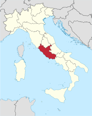
Lazio or Latium is one of the 20 administrative regions of Italy. Situated in the central peninsular section of the country, it has 5,714,882 inhabitants and a GDP of more than €197 billion per year, making it the country's second most populated region and second largest regional economy after Lombardy. The capital of Lazio is Rome, which is also the capital and largest city of Italy.

Pope Celestine IV, born Goffredo da Castiglione, was head of the Catholic Church and ruler of the Papal States for only a few days from 25 October 1241 to his death in 10 November 1241.
The Sabines were an Italic people who lived in the central Apennine Mountains of the ancient Italian Peninsula, also inhabiting Latium north of the Anio before the founding of Rome.

Amiternum was an ancient Sabine city, then Roman city and later bishopric and Latin Catholic titular see in the central Abruzzo region of modern Italy, located 9 km (5.6 mi) from L'Aquila. Amiternum was the birthplace of the historian Sallust.

Cures was an ancient Sabine town between the left bank of the Tiber and the Via Salaria, about 26 miles (42 km) from Rome, in central Italy. Its remains are located in the modern commune of Fara Sabina. According to legend, it was from Cures that Titus Tatius led to the Quirinal the Sabine settlers, from whom, after their union with the settlers on the Palatine, the whole Roman people took the name Quirites. Another legend, related by Dionysius, connects the foundation of Cures with the worship of the Sabine god Quirinus, whence Quirites.

GiacomoBarozzida Vignola, often simply called Vignola, was one of the great Italian architects of 16th century Mannerism. His two great masterpieces are the Villa Farnese at Caprarola and the Jesuits' Church of the Gesù in Rome. The three architects who spread the Italian Renaissance style throughout Western Europe are Vignola, Serlio and Palladio. He is often considered the most important architect in Rome in the Mannerist era.

Rieti is a town and comune in Lazio, central Italy, with a population of 47,700. It is the administrative seat of the province of Rieti and see of the diocese of Rieti, as well as the modern capital of the Sabina region.

Farfa Abbey is a territorial abbey in northern Lazio, central Italy. In the Middle Ages it was one of the richest and most famous abbeys in Italy. It belongs to the Benedictine Order and is located about 60 km (37 mi) from Rome, in the commune of Fara Sabina, of which it is also a hamlet.

Sabina, also called the Sabine Hills, is a region in central Italy. It is named after Sabina, the territory of the ancient Sabines, which was once bordered by Latium to the south, Picenum to the east, ancient Umbria to the north and Etruria to the west. It was separated from Umbria by the River Nar, today's Nera, and from Etruria by the River Tiber.

Fiano Romano is a town and comune (municipality) in the Metropolitan City of Rome, Italy, approximately 40 kilometres (25 mi) north of that city.

Mentana is a town and comune, former bishopric and present Latin Catholic titular see in the Metropolitan City of Rome, Lazio, central Italy. It is located 29 kilometres (18 mi) north-east of Rome and has a population of about 23,000.

Fara in Sabina is a comune (municipality) in the Province of Rieti in the Italian region of Lazio, located about 40 kilometres (25 mi) northeast of Rome and about 25 kilometres (16 mi) southwest of Rieti.

Montopoli di Sabina is a town and comune (municipality) in the Province of Rieti in the Italian region of Latium, located about 40 kilometres (25 mi) northeast of Rome and about 20 kilometres (12 mi) southwest of Rieti. In 2011, it had a population of 4,222.

Montelibretti is a town and comune (municipality) in the Metropolitan City of Rome in the Italian region of Lazio, located about 30 kilometres (19 mi) northeast of Rome on the slopes of Monti Sabini.

The Diocese of Rieti is a Latin Church ecclesiastical territory or diocese of the Catholic Church in Italy. It is immediately exempt to the Holy See. Its cathedra is in St. Mary Cathedral in the episcopal see of Rieti.
Sabina is a Protected Designation of Origin (PDO) that applies to the extra virgin olive oil produced in the Sabina region. This area approximately covers the territory originally occupied by the ancient Sabines tribe in the Province of Rome and the Province of Rieti. It is considered to be the first Italian PDO to gain the status, later being followed by Aprutino Pescarese, Brisighella, Collina di Brindisi and Canino.

Strada statale 4 Via Salaria is an Italian state highway, linking Rome to the Adriatic sea passing through Rieti and Ascoli Piceno. Its route retraces that of the ancient Via Salaria Roman road. It is a single carriageway highway for most of its route.

Strada statale 4 Dir or SS 4 Dir or SS 4 Salaria Dir is a short Italian state highway, linking Strada statale 4 Via Salaria at Passo Corese to the A1 motorway at Fiano Romano.

The via Tiberina was an ancient Roman road, which from the north of Rome, going up the right bank of the Tiber valley, crossed the ancient Faliscan-Capenate countryside to reach the Sabina and continued towards Ocriculum in Umbria. Today, in the metropolitan city of Rome Capital, its route coincides with the provincial road 15 / A Tiberina.


