Strada statale 4 Via Salaria

Last updated
Strada Statale 4 Italia.svg
State Highway 4
Strada statale 4
Salaria
Italia - mappa strada statale 4.svg
Route information
Maintained by ANAS
Length208.2 km (129.4 mi)
reduced to 175 km since the Ascoli-Porto d'Ascoli trait was declassed to provincial road
Existed1928–present
Major junctions
FromCity centre of Rome
Major intersections Tangenziale Est and GRA in Rome; Autostrada A1 at Settebagni; SS 313 in Passo Corese; SS 636 di Palombara at Borgo Quinzio; SS 79 Ternana and SS 578 Salto Cicolana in Rieti; SS 17 in Antrodoco; SS 471 di Leonessa at Posta; SS 260 Picente at Amatrice; SS 685 delle Tre Valli Umbre at Arquata del Tronto; Raccordo autostradale 11 and SS 81 Piceno Aprutina at Ascoli Piceno
To SS 16 Adriatica at Porto d'Ascoli
Location
Country Italy
Regions Lazio, Marche
Highway system
Strada Statale 3 Italia.svg SS 3Strada Statale 5 Italia.svg SS 5

Strada statale 4 Via Salaria is an Italian state highway, linking Rome to the Adriatic Sea passing through Rieti and Ascoli Piceno. Its route retraces that of the ancient Via Salaria Roman road. It is a single carriageway highway for most of its route.

Contents

Route

Rome to Rieti

SS 4 as seen near Poggio San Lorenzo Strada Statale 4 Via Salaria - km 58 (2).JPG
SS 4 as seen near Poggio San Lorenzo

Strada statale 4 Via Salaria starts Northeast of Rome, just outside the Aurelian Walls, where until 1921 Porta Salaria was located to control access to the city. The initial stretch of SS 4 is more similar to an urban road than to a highway, as the area has now become densely populated and buildings have been raised by the roadside. After four kilometres SS4 meets Tangenziale Est di Roma and, from that point on, becomes a busy dual carriageway urban road, filled by people leaving or entering the city.

In the Castel Giubileo neighborhood, SS4 exits the city of Rome and meets Grande Raccordo Anulare (GRA), where most of the traffic flows. Immediately after, the road returns a single carriageway highway; in fact the subsequent 20 kilometer stretch, from the GRA to Passo Corese, has seen his importance reduced since the 6-lane Autostrada A1 runs parallel to it and absorbs most of the long-distance traffic. Nevertheless, SS4 remains important to many mid-sized towns in Rome's hinterland, such as Settebagni, Monterotondo and Mentana.

Passo Corese marks both the point where SS4 enters the Province of Rieti and the point where it diverges from Autostrada A1, receiving from it all traffic to the Adriatic. The road here leaves the Tiber valley and ventures into the more hilly Sabina region, commencing its long, gradual ascent to the Apennines. For this reason, SS4 had once a rather rough course from here on, with tight bends and continuous rises and descents; current SS4 is a completely new road (constructed in the 1960s to replace the old one from Passo Corese to Rieti), much more straight and wide, albeit still with a single carriageway.

The 4.5 km (2.8 mi), dual carriageway road tunnel "Colle Giardino", near Rieti SS 4 Salaria - galleria Colle Giardino - imbocco nord.jpg
The 4.5 km (2.8 mi), dual carriageway road tunnel "Colle Giardino", near Rieti

As the road passes the Sabine mountains, it reaches an altitude of 400 metres above sea level at Osteria Nuova and it descents into a narrow valley, then rises again until reaching 570 metres in the village of Ornaro, and finally descents.

6 km (3.7 mi) south of province capital Rieti the road becomes a dual carriageway road; the long "Colle Giardino" road tunnel allows the road to leave Sabine mountains behind and to enter the Rieti plain (400 metres on sea level) where the city is settled.

Rieti to the Adriatic

Dual carriageway trait in Rieti Statale Salaria - variante di Rieti da Salaria vecchia (dir. Roma) 02.jpg
Dual carriageway trait in Rieti

In Rieti SS4 turns sharply into East, quickly leaves the Rieti plain and prosecutes in the Velino valley. Shortly before Cittaducale, the road returns a single carriageway and pretty narrow road, which still needs to be uprated and follows a similar path to the ancient Roman road. While slightly ascending, SS4 reaches the spa town of Cotilia and then Antrodoco, where it joins State Highway 17 to L'Aquila.

The Velino viaduct, in the Gole del Velino canyon Strada statale 4 Via Salaria - viadotto Velino (1).jpg
The Velino viaduct, in the Gole del Velino canyon

In Antrodoco (470 metres on sea level) the road follows the river's valley, bending to the north and entering the narrow "Gole del Velino" canyon. Here SS4 becomes similar to a mountain road, since bends become more tight and the ascent more steep; but halfway through the canyon, a recently uprated stretch of the road begins, where tunnels and viaducts make the road smoother albeit still with a single carriageway.

In Posta, at 700 metres above sea level, SS4 leaves the canyon and keeps going up in a broader plateau. Shortly after Cittareale the highway reaches its upper point, the Torrita Pass, at around 1010 metres on the sea level.

From here on the roads descents following the course of the narrow Tronto valley. Soon after Amatrice and Accumoli, the road leaves Lazio and enters the region of Marche. Passing through Arquata del Tronto (780 metres on sea level) and Acquasanta Terme (390 metres), SS4 keeps descending until it reaches province capital Ascoli Piceno (150 metres on sea level).

After Ascoli the road continues towards the Adriatic Sea with a rather winding path, where it ends in a junction with SS 16 Adriatica and the Autostrada A14 in Porto d'Ascoli (near San Benedetto del Tronto). Still, such trait has been recently declassed to provincial road, since it has been replaced by Raccordo autostradale 11, a more modern dual carriageway road.

Future interventions

Today SS4 is a busy road between Rieti and Passo Corese, as it is the main road link between Rieti and Rome; motorists use it to reach the Autostrada A1 in Passo Corese and continue towards Rome in the more modern road. In this trait SS4 has a single, albeit reasonably wide carriageway, which was constructed in the 1960s in place of an earlier, less smooth road. [1] For this reason, Italian Government plans to make SS4 a dual carriageway road between Rieti and Passo Corese, but around 1.5 billion euros are needed [2] and it is not known when funds will be granted.

Uprating of the trait from Cittaducale to Posta, where the carriageway is rather narrow and the road climbs up the Apennine mountains, is also planned to make the carriageway wider and less winding - even if the road will remain with a single carriageway. The first part of these road works started in 2005 on the Posta-Micigliano stretch [3] and are currently underway.

Related Research Articles

<span class="mw-page-title-main">Transport in Italy</span> Overview of the transport in Italy

Italy has a well developed transport infrastructure. The Italian rail network is extensive, especially in the north, and it includes a high-speed rail network that joins the major cities of Italy from Naples through northern cities such as Milan and Turin. The Florence–Rome high-speed railway was the first high-speed line opened in Europe when more than half of it opened in 1977. Italy has 2,507 people and 12.46 km2 per kilometer of rail track, giving Italy the world's 13th largest rail network. The Italian rail network is operated by state-owned Ferrovie dello Stato, while the rail tracks and infrastructure are managed by Rete Ferroviaria Italiana.

<span class="mw-page-title-main">Apennine Mountains</span> Mountain ranges stretching the length of Italy

The Apennines or Apennine Mountains are a mountain range consisting of parallel smaller chains extending c. 1,200 km (750 mi) along the length of peninsular Italy. In the northwest they join with the Ligurian Alps at Altare. In the southwest they end at Reggio di Calabria, the coastal city at the tip of the peninsula. Since 2000 the Environment Ministry of Italy, following the recommendations of the Apennines Park of Europe Project, has been defining the Apennines System to include the mountains of north Sicily, for a total distance of 1,500 kilometres (930 mi). The system forms an arc enclosing the east side of the Ligurian and Tyrrhenian seas.

<span class="mw-page-title-main">Ascoli Piceno</span> Town in Marche, Italy

Ascoli Piceno is a comune (municipality) and capital of the province of Ascoli Piceno, in the Marche region of Italy.

<span class="mw-page-title-main">Dual carriageway</span> Type of road

A dual carriageway (BrE) or a divided highway (AmE) is a class of highway with carriageways for traffic travelling in opposite directions separated by a central reservation (BrE) or median (AmE). Roads with two or more carriageways which are designed to higher standards with controlled access are generally classed as motorways, freeways, etc., rather than dual carriageways.

<span class="mw-page-title-main">Via Salaria</span> Ancient Roman road in Italy

The Via Salaria was an ancient Roman road in Italy. It eventually ran from Rome to Castrum Truentinum on the Adriatic coast, a distance of 242 km. The road also passed through Reate (Rieti) and Asculum.

<span class="mw-page-title-main">Province of Teramo</span> Province of Italy

The province of Teramo is a province in the Abruzzo region of Italy. Its capital is the city of Teramo. The province has an area of 1,948 square kilometres (752 sq mi), a population of 313,029 (2012), and is subdivided into 47 comuni, see comunes of the province of Teramo. The province of Teramo shares its northern border with the province of Ascoli Piceno in the Marche region, southern and southwestern borders with the province of L'Aquila in the Abruzzo region, and a western border with the province of Rieti in the Lazio region. To the south is the province of Pescara in the Abruzzo region and to the east is the Adriatic Sea.

<span class="mw-page-title-main">Road hierarchy</span> Hierarchy in road traffic

The road hierarchy categorizes roads according to their functions and capacities. While sources differ on the exact nomenclature, the basic hierarchy comprises freeways, arterials, collectors, and local roads. Generally, the functional hierarchy can more or less correspond to the hierarchy of roads by their owner or administrator.

<span class="mw-page-title-main">Autostrade of Italy</span> National motorway system of Italy

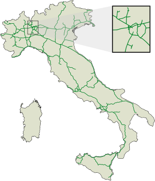
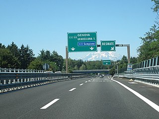
The autostrade are roads forming the Italian national system of motorways. The total length of the system is about 7,016 kilometres (4,360 mi), as of 30 July 2022. To these data are added 13 motorway spur routes, which extend for 355 kilometres (221 mi).

<span class="mw-page-title-main">Rieti</span> Comune in Lazio, Italy

Rieti is a town and comune in Lazio, central Italy, with a population of 47,700. It is the administrative seat of the province of Rieti and see of the diocese of Rieti, as well as the modern capital of the Sabina region.

<span class="mw-page-title-main">San Benedetto del Tronto</span> City and comune in Marche, Italy

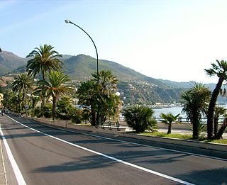
San Benedetto del Tronto is a city and comune in Marche, Italy. Part of an urban area with 100,000 inhabitants, it is one of the most densely populated areas along the Adriatic Sea coast. It is the most populated city in Province of Ascoli Piceno, with 47,034. Its port is one of the biggest on the Adriatic; it is the most important centre of Riviera of the Palms, with over 8,000 Phoenix canariensis, Washingtonia and P. sylvestris plants. San Benedetto del Tronto's economy depends on tourism, aimed above all at families.

<span class="mw-page-title-main">Antrodoco</span> Comune in Lazio, Italy

Antrodoco is a town and comune in the province of Rieti, in the Lazio region of central Italy. The name derives from the Latin Interocrea.

<span class="mw-page-title-main">Monti della Laga</span>

Monti della Laga is a mountain range in the central Apennines of Italy. Their ruggedness and inaccessibility makes them one of the lesser known areas of the Italian peninsula.

<span class="mw-page-title-main">Grande Raccordo Anulare</span> Road in Italy

The GRA or Grande Raccordo Anulare is a toll-free, ring-shaped 68.2 kilometres (42.4 mi) long orbital motorway that encircles Rome. GRA is one of the most important roads in Rome, and traffic reaches 160,000 vehicles per day as of 2011.

<span class="mw-page-title-main">Autostrada A24 (Italy)</span> Controlled-access highway in Italy

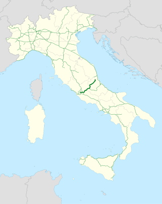
The Autostrada A24, or Autostrada dei Parchi is an autostrada 166 kilometres (103 mi) long connecting Rome to Teramo. Starting at the Grande Raccordo Anulare, the A24 runs broadly north-east past L'Aquila and through a 10 kilometres (6.2 mi) tunnel under the Gran Sasso before reaching Teramo. Strada dei Parchi S.p.A. currently manages the route. The name "Parks Motorway" comes from the fact that the Maiella National Park, the Abruzzo, Lazio and Molise National Park and the Gran Sasso e Monti della Laga National Park can be reached from this motorway.

<span class="mw-page-title-main">Autostrada A26 (Italy)</span> Controlled-access highway in Italy

The Autostrada A26 is an autostrada 197.1 kilometres (122.5 mi) long in the northwestern Italian regions of Liguria and Piedmont. It is named the Autostrada dei Trafori after the numerous tunnels through which it passes, both Apennine and Subalpine. It runs northwards from Genoa on the Ligurian coast, over the Apennines, and across the wide plain of the Po valley to the environs of Lake Maggiore and the mouth of the Val d’Ossola. In addition to this ‘main trunk’ of the road, there are three side branches, also of motorway class which function as link roads between the A26 and the A7, the A4 and the A8. The A26, together with these link roads, is managed by Autostrade per l'Italia S.p.A.

<span class="mw-page-title-main">Autostrada A18 (Italy)</span> Controlled-access highway in Italy

The Autostrada A18 is an autostrada 77 kilometres (48 mi) long on the Ionian coast of Sicily that links Messina to Catania. The motorway is linked to the A20 Messina-Palermo at its northern end and to the A19 Palermo-Catania through the RA15 Catania's Ring Road at its southern end. There is also a second stretch of the Autostrada A18, 59.1 kilometres (36.7 mi) long, on the south part of the island, running from Syracuse to Modica, and with the plan to extend it to Gela.

<span class="mw-page-title-main">Passo Corese</span> Frazione in Lazio, Italy

Passo Corese is an Italian town and hamlet (frazione) of Fara in Sabina, a municipality in the province of Rieti, Lazio. In 2011 it had a population of 3,573.

<span class="mw-page-title-main">State highways (Italy)</span> State highway system of Italy

The Strade Statali, abbreviated SS, are the Italian national network of state highways. The total length of the network is about 25,000 km (16,000 mi).

<span class="mw-page-title-main">Roads in Italy</span> Overview of the various types of roads in Italy

Roads in Italy are an important mode of transport in Italy. The classification of the roads of Italy is regulated by the Italian traffic code, both from a technical and administrative point of view. The street nomenclature largely reflects the administrative classification. Italy is one of the countries with the most vehicles per capita, with 690 per 1000 people in 2010.

<span class="mw-page-title-main">Strada statale 4 dir</span> Italian state highway

Strada statale 4 Dir or SS 4 Dir or SS 4 Salaria Dir is a short Italian state highway, linking Strada statale 4 Via Salaria at Passo Corese to the A1 motorway at Fiano Romano.

References

  1. "Relazione di sintesi". Ministero dell'Ambiente. 21 June 2007. Retrieved 8 March 2016.
  2. Camera dei deputati - Sistema Informativo Legge Opere Strategiche
  3. "Via all'appalto del primo lotto della Salaria". Il Tempo, Rieti edition. 12 May 2005. Archived from the original on 25 March 2016. Retrieved 17 March 2016.