Italy has a well developed transport infrastructure. The Italian rail network is extensive, especially in the north, and it includes a high-speed rail network that joins the major cities of Italy from Naples through northern cities such as Milan and Turin. The Florence–Rome high-speed railway was the first high-speed line opened in Europe when more than half of it opened in 1977. Italy has 2,507 people and 12.46 km2 per kilometer of rail track, giving Italy the world's 13th largest rail network. The Italian rail network is operated by state-owned Ferrovie dello Stato, while the rail tracks and infrastructure are managed by Rete Ferroviaria Italiana.

A state highway, state road, or state route is usually a road that is either numbered or maintained by a sub-national state or province. A road numbered by a state or province falls below numbered national highways in the hierarchy.

The Via Salaria was an ancient Roman road in Italy. It eventually ran from Rome to Castrum Truentinum on the Adriatic coast, a distance of 242 km. The road also passed through Reate (Rieti) and Asculum.
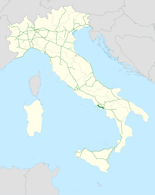
The Autostrada A3 is an autostrada 53.6 kilometres (33.3 mi) long in Italy located in the region of Campania, which runs from Naples to Salerno. It is a part of the E45 European route.
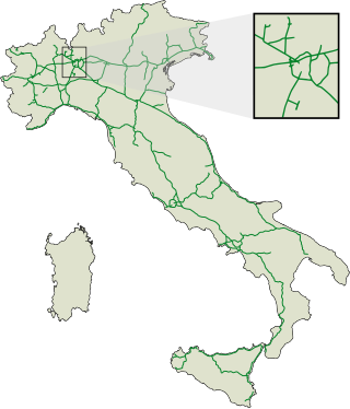
The autostrade are roads forming the Italian national system of motorways. The total length of the system is about 7,016 kilometres (4,360 mi), as of 30 July 2022. There are also 13 motorway spur routes, which extend for 355 kilometres (221 mi).

Antrodoco is a town and comune in the province of Rieti, in the Lazio region of central Italy. The name derives from the Latin Interocrea.

Autostrada A90 or Grande Raccordo Anulare or GRA is a ring-shaped autostrada 68.2 kilometres (42.4 mi) long in Italy located in the region of Lazio that encircles Rome. It is a part of the E80 European route. GRA is one of the most important roads in Rome, and traffic reaches 160,000 vehicles per day as of 2011.
The Autostrada A24, or Strada dei Parchi is an autostrada 166 kilometres (103 mi) long in Italy located in the regions of Lazio and Abruzzo connecting Rome to Teramo, near the Adriatic Sea. Starting from the Grande Raccordo Anulare, the A24 runs broadly north-east across the Abruzzese Apennine Mountains. Between L'Aquila and Teramo it passes through the 10 kilometres (6.2 mi) Gran Sasso Tunnel. The private company Strada dei Parchi S.p.A. currently manages the motorway. The name "Parks Motorway" comes from the fact that the Maiella National Park, the Abruzzo, Lazio and Molise National Park and the Gran Sasso e Monti della Laga National Park can be reached from this motorway. It is a part of the E80 European route.

The Autostrada A18 is an autostrada 77 kilometres (48 mi) long in Italy on the Ionian coast of Sicily that links Messina to Catania. The motorway is linked to the A20 Messina-Palermo at its northern end and to the A19 Palermo-Catania through the RA15 Catania's Ring Road at its southern end. There is also a second stretch of the Autostrada A18, 59.1 kilometres (36.7 mi) long, on the south part of the island, running from Syracuse to Modica, and with the plan to extend it to Gela. It is a part of the E45 European route.

The Autostrada A91, also called Autostrada Roma-Fiumicino, is an autostrada 18.5 kilometres (11.5 mi) long in Italy located in the region of Lazio which connects Rome to the Leonardo da Vinci–Fiumicino Airport in Fiumicino. It is a part of the E80 European route.

Passo Corese is an Italian town and hamlet (frazione) of Fara in Sabina, a municipality in the province of Rieti, Lazio. In 2011 it had a population of 3,573.
The Strade Statali, abbreviated SS, are the Italian national network of state highways. The total length of the network is about 25,000 km (16,000 mi).

Roads in Italy are an important mode of transport in Italy. The classification of the roads of Italy is regulated by the Italian traffic code, both from a technical and administrative point of view. The street nomenclature largely reflects the administrative classification. Italy is one of the countries with the most vehicles per capita, with 690 per 1000 people in 2010.

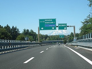
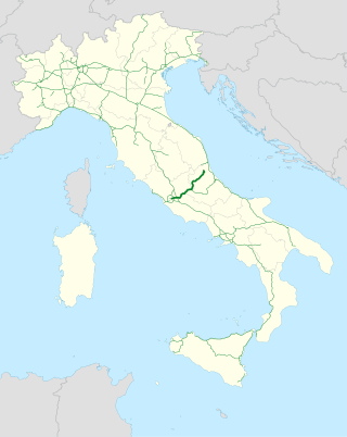
Strada statale 4 Via Salaria is an Italian state highway 208.2 kilometres (129.4 mi) long in Italy located in the regions of Lazio and Marche, linking Rome to the Adriatic Sea passing through Rieti and Ascoli Piceno. Its route retraces that of the ancient Via Salaria Roman road. It is a single carriageway highway for most of its route.

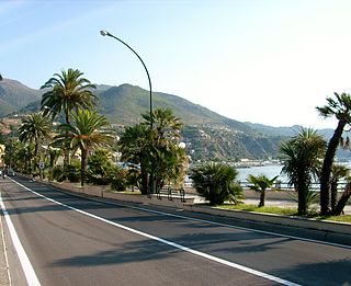
Strada statale 1 Via Aurelia is an Italian state highway 697.3 kilometres (433.3 mi) long in Italy located in the regions of Lazio, Tuscany and Liguria. It is one of the most important state highways in Italy and derives from an ancient Roman consular road, the Via Aurelia. It connects Rome with France following the coast of Tyrrhenian Sea and Ligurian Sea and touching nine provincial capitals as well as important tourist locations. It constitutes a section of the European route E80 from Tarquinia to Rosignano Marittimo

Raccordo autostradale 4 or Raccordo autostradale di Reggio Calabria or Tangenziale di Reggio Calabria is an autostrada 5.5 kilometres (3.4 mi) long in Italy located in the region of Calabria that connects the Autostrada A2 with the Strada statale 106 Jonica through the city of Reggio Calabria. The motorway junction also constitutes the central section of the so-called "Reggio Calabria ring road". It is a part of the E90 European route.

Raccordo autostradale 6 or Raccordo autostradale Bettolle-Perugia is an autostrada 59.3 kilometres (36.8 mi) long in Italy located in the regions of Tuscany and Umbria, and managed by ANAS, that allows a quick connection of the Strada statale 3 bis Tiberina near the city of Perugia with the Autostrada A1 where the route begins in the locality of Bettolle, municipality of Sinalunga. The RA 6 is a seamless continuation of the Strada statale 715 Siena-Bettolle and, on the other end, it continues as Strada statale 75 Centrale Umbra up to Foligno.

Raccordo autostradale 11 or superstrada Ascoli-Mare is an autostrada 26.0 kilometres (16.2 mi) long in Italy located in the regions of Marche and Abruzzo, and managed by ANAS, which connects Ascoli Piceno to the Autostrada A14 near to the Adriatic Sea, as a variant to the old route of Strada statale 4 "Via Salaria" that previously carried out that function.

Autostrada Sistiana–Rabuiese is an autostrada 10.1 kilometres (6.3 mi) long without toll, managed by ANAS consisting of two sections connected to each other by the Strada statale 202 Triestina which connects the Raccordo autostradale RA13 in Italy and the Hitra cesta H5 in Slovenia crossing the Italian city of Trieste in Friuli-Venezia Giulia region. The highway does not have a definitive numbering and is therefore devoid of an alphanumeric abbreviation of the type "Ax" or "Axx".

Strada statale 7 Via Appia is an Italian state highway 713.45 kilometres (443.32 mi) long in Italy located in the regions of Lazio, Campania, Basilicata and Apulia that follows the path of the ancient Appian Way, connecting Rome to Brindisi. In the stretch between Cisterna di Latina and Terracina, the SS 7 is called "fettuccia di Terracina" due to its straight line. It constitutes a section of the European route E90 from Taranto to Brindisi.