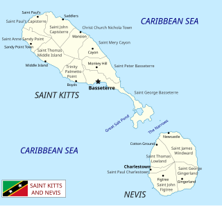
Saint Kitts and Nevis is a twin island country with a total landmass of just 270 square kilometres (104 sq mi). The island of St. Kitts, the larger of the two, is 180 square kilometres (68 sq mi) in size and is located at latitude 17.30 N, and longitude 62.80 W. Nevis is 93 square kilometres (36 sq mi) and located at latitude 17.10 N, longitude 62.35 W, approximately 3 km south-east of St. Kitts. The islands are about one-third of the way from Puerto Rico to Trinidad and Tobago. The islands are volcanic and mountainous.

Trinidad and Tobago is an archipelagic republic in the southern Caribbean between the Caribbean Sea and the North Atlantic Ocean, northeast of Venezuela. They are southeasterly islands of the Lesser Antilles, Monos, Huevos, Gaspar Grande, Little Tobago, and St. Giles Island. Trinidad is 11 km (6.8 mi) off the northeast coast of Venezuela and 130 km (81 mi) south of the Grenadines. The island measures 4,768 km2 (1,841 sq mi) in area with an average length of 80 km (50 mi) and an average width of 59 km (37 mi). The island appears rectangular in shape with three projecting peninsular corners. Tobago is 30 km (19 mi) northeast of Trinidad and measures about 298 km2 (115 sq mi) in area, or 5.8% of the country's area, 41 km (25.5 mi) in length and 12 km (7.5 mi) at its greatest width. The island is cigar-shaped in appearance, with a northeast–southwest alignment.

Tropical climate is the first of the five major climate groups in the Köppen climate classification identified with the letter A. Tropical climates are defined by a monthly average temperature of 18 °C (64.4 °F) or higher in the coolest month, and feature hot temperatures all year-round. Annual precipitation is often abundant in tropical climates, and shows a seasonal rhythm but may have seasonal dryness to varying degrees. There are normally only two seasons in tropical climates, a wet (rainy/monsoon) season and a dry season. The annual temperature range in tropical climates is normally very small. Sunlight is intense in these climates.

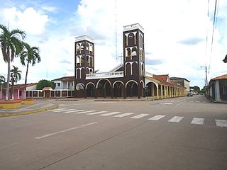
Retalhuleu is a department located in the south-west of Guatemala, extending from the mountains to the Pacific Ocean coast. It has an area of 1856 km2. In 2018 the population of the Department of Retalhuleu was 326,828. Its capital, Retalhuleu City, mixes ancient and modern architecture, and it is also known for being a commercial city.

San Fernando, officially the City of San Fernando, is the most populous city and second most populous municipality in Trinidad and Tobago, after Chaguanas. Sando, as it is known to many local Trinidadians, occupies 19 km² and is located in the southwestern part of the island of Trinidad. It is bounded to the north by the Guaracara River, the south by the Oropouche River, the east by the Sir Solomon Hochoy Highway, and the west by the Gulf of Paria. The former borough was elevated to the status of a city corporation on 18 November 1988. The motto of San Fernando is: "Sanitas Fortis" - In a Healthy Environment We Will Find Strength. San Fernando is called Trinidad and Tobago's "industrial capital" because of its proximity to the Pointe-à-Pierre oil refinery and many other petrochemical, LNG, iron and steel and aluminium smelters in places such as Point Lisas in Couva, Point Fortin, and La Brea.

Arima, officially The Royal Chartered Borough of Arima is the easternmost and second largest in area of the three boroughs of Trinidad and Tobago. It is geographically adjacent to Sangre Grande and Arouca at the south central foothills of the Northern Range. To the south is the Caroni–Arena Dam. Coterminous with Town of Arima since 1888, the borough of Arima is the fourth-largest municipality in population in the country. The census estimated it had 33,606 residents in 2011.
Princes Town is a town within an eponymous region, located on south-Central Trinidad island in Trinidad and Tobago. The population of the town is 28,335.

Bangassou is a city in the south eastern Central African Republic, lying on the north bank of the Mbomou River. It has a population of 24,447 and is the capital of the Mbomou prefecture. It is known for its wildlife, market, and nearby Bangassou Airport and is linked by ferry to the Democratic Republic of Congo on the south bank. The city is also home to the Roman Catholic Diocese of Bangassou.

Trinidad, officially La Santísima Trinidad, is a city in Bolivia, capital of the department of Beni. The population is 130,000. While historically a peripheral city in Bolivia, Trinidad is today an important center for the Bolivian Bovine industry and has enjoyed a modest economic boom in recent years and enjoys an HDI index of above 0.700.

Cruz Bay, U.S. Virgin Islands is the main town on the island of Saint John in the United States Virgin Islands. According to the 2000 census, Cruz Bay had a population of 2,743.

Kindu is a city in the Democratic Republic of Congo, the capital of Maniema province. It has a population of about 200,000 and is situated on the Lualaba River at an altitude of about 500 metres, and is about 400 km west of Bukavu.
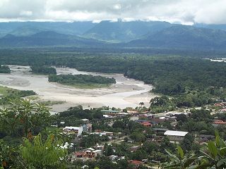
Villa Tunari or Tunari is a location in the department of Cochabamba, Bolivia. It is the seat of the Villa Tunari Municipality, the third municipal section of the Chapare Province. According to the census 2012 the population was 3,213 in the town which is an increment from 2,510 registered during the 2001 census.

Marigot is the main town and capital in the French Collectivity of Saint Martin.
Mallapur is also known as Mallapuram before (2000's) is a neighbourhood in Hyderabad in the Indian state of Telangana. It falls under Uppal mandal of Medchal-Malkajgiri district. It is administered as Ward No. 5 of Greater Hyderabad Municipal Corporation.

Tropical savanna climate or tropical wet and dry climate is a tropical climate sub-type that corresponds to the Köppen climate classification categories Aw and As. The driest month has less than 60 mm (2.4 in) of precipitation and also less than mm of precipitation.
Santa Ana del Yacuma is a town in the Beni Department in north-eastern Bolivia.

San Joaquín is a small agricultural town in the Beni Department in the Bolivian lowlands.
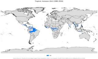
An area of tropical monsoon climate is a tropical climate sub-type that corresponds to the Köppen climate classification category Am. Tropical monsoon climates have monthly mean temperatures above 18 °C (64 °F) in every month of the year and a dry season. The tropical monsoon climate is the intermediate climate between the wet Af and the drier Aw.

Keta Municipal District is one of the eighteen districts in Volta Region, Ghana. Originally created as an ordinary district assembly in 1988 when it was known as Keta District, which was created from the former Anlo District Council, until it was elevated to municipal district assembly status on 1 November 2007 to become Keta Municipal District. However on 19 February 2019, the western part of the district was split off to create Anloga District; thus the remaining part has been retained as Keta Municipal District. The municipality is located in the southeast part of Volta Region and has Keta as its capital town.

The Trinidad and Tobago moist forests ecoregion covers most of Trinidad Island and Tobago Island near the coast of South America where the southeastern Caribbean Sea meets the Atlantic Ocean. Small portions of the islands around river estuaries and coastal lowlands are mangroves or dry forests. Species diversity is very high, in particular for plants and birds. Tobago, being much smaller, has fewer species.
