
Prairies are ecosystems considered part of the temperate grasslands, savannas, and shrublands biome by ecologists, based on similar temperate climates, moderate rainfall, and a composition of grasses, herbs, and shrubs, rather than trees, as the dominant vegetation type. Temperate grassland regions include the Pampas of Argentina, Brazil and Uruguay, and the steppe of Ukraine, Russia, and Kazakhstan. Lands typically referred to as "prairie" tend to be in North America. The term encompasses the lower and mid-latitude of the area referred to as the Interior Plains of Canada, the United States, and Mexico. It includes all of the Great Plains as well as the wetter, hillier land to the east. From west to east, generally the drier expanse of shortgrass prairie gives way to mixed grass prairie and ultimately the richer soils of the tallgrass prairie.
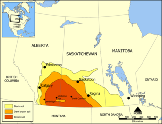
The Missouri Coteau, or Missouri Plateau, is a large plateau that stretches along the eastern side of the valley of the Missouri River in central North Dakota and north-central South Dakota in the United States. In the Canadian provinces of Saskatchewan and Alberta this physiographic region is classified as the Uplands Missouri Coteau, which is a part of the Great Plains Province or Alberta Plateau Region, which extends across the southwest corner of the province of Saskatchewan as well as the southeast corner of the province of Alberta. Historically, in Canada the area was known as the Palliser's Triangle and regarded as an extension of the Great American Desert and unsuitable for agriculture and thus designated by Canadian geographer and explorer John Palliser. The terrain of the Missouri Coteau features low hummocky, undulating, rolling hills, potholes, and grasslands. Apart from being a geographical area, the Missouri Coteau also has a cultural connection to the people of the area, the Métis people of South Dakota, along with other Indigenous groups. The history of this plateau is large, and the Missouri Coteau has a significance to these people.

The tallgrass prairie is an ecosystem native to central North America. Historically, natural and anthropogenic fire, as well as grazing by large mammals provided periodic disturbances to these ecosystems, limiting the encroachment of trees, recycling soil nutrients, and facilitating seed dispersal and germination. Prior to widespread use of the steel plow, which enabled large scale conversion to agricultural land use, tallgrass prairies extended throughout the American Midwest and smaller portions of southern central Canada, from the transitional ecotones out of eastern North American forests, west to a climatic threshold based on precipitation and soils, to the southern reaches of the Flint Hills in Oklahoma, to a transition into forest in Manitoba.

The Flint Hills, historically known as Bluestem Pastures or Blue Stem Hills, are a region of hills and prairies that lie mostly in eastern Kansas. It is named for the abundant residual flint eroded from the bedrock that lies near or at the surface. It consists of a band of hills extending from Marshall and Washington Counties in the north to Cowley County, Kansas and Kay and Osage Counties in Oklahoma in the south, to Geary and Shawnee Counties west to east. Oklahomans generally refer to the same geologic formation as the Osage Hills or "the Osage."

The Midewin National Tallgrass Prairie (MNTP) is a tallgrass prairie reserve and is preserved as United States National Grassland operated by the United States Forest Service. The first national tallgrass prairie ever designated in the United States and the largest conservation site in the Chicago Wilderness region, it is located on the site of the former Joliet Army Ammunition Plant between the towns of Elwood, Manhattan and Wilmington in northeastern Illinois. Since 2015, it has hosted a conservation herd of American bison to study their interaction with prairie restoration and conservation.

Buffalo River State Park is a state park of Minnesota, United States, conserving a prairie bisected by the wooded banks of the Buffalo River. Together with the adjacent Bluestem Prairie Scientific and Natural Area co-owned by The Nature Conservancy and Minnesota's Department of Natural Resources, it protects one of the largest and highest-quality prairie remnants in Minnesota. It used to offer a man-made swimming pond close to the Fargo–Moorhead metropolitan area, however, that has not been open since 2018. Presently, it is most popular for its high quality educational programming, swimming in the Buffalo River, and picnicking. The 1,068-acre (432 ha) park is located just off U.S. Route 10 in Clay County, 4.5 miles (7.2 km) east of Glyndon and 14 miles (23 km) east of Moorhead.
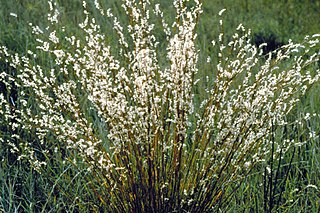
Schizachyrium scoparium, commonly known as little bluestem or beard grass, is a species of North American prairie grass native to most of the contiguous United States as well as a small area north of the Canada–US border and northern Mexico. It is most common in the Midwestern prairies and is one of the most abundant native plants in Texas grasslands.

The Chase Lake Prairie Project is considered the "National Flagship Project" of the North American Waterfowl Management Plan (NAWMP). The goal is to rehabilitate 5,500,000 acres (2,200,000 ha) of wetland around Chase Lake on the Missouri Coteau. The project was dedicated in September 1989.
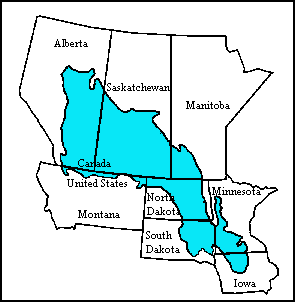
The Prairie Pothole Region is an expansive area of the northern Great Plains that contains thousands of shallow wetlands known as potholes. These potholes are the result of glacier activity in the Wisconsin glaciation, which ended about 10,000 years ago. The decaying ice sheet left behind depressions formed by the uneven deposition of till as buried ice blocks melted in ground moraines. These depressions are called potholes, glacial potholes, kettles, or kettle lakes. They fill with water in the spring, creating wetlands, which range in duration from temporary to semi-permanent. The region covers an area of about 800,000 sq. km and expands across three Canadian provinces and five U.S. states. The hydrology of the wetlands is variable, which results in long term productivity and biodiversity. The PPR is a prime spot during breeding and nesting season for millions of migrating waterfowl.

Buffalo Ridge is a large expanse of rolling hills in the southeastern part of the larger Coteau des Prairies. It stands 1,995 feet (608 m) above sea level. The Buffalo Ridge is sixty miles (97 km) long and runs through Lincoln, Pipestone, Murray, Nobles, and Rock counties in the southwest corner of Minnesota, and Minnehaha, Moody, and Lincoln counties in southeast South Dakota.

Glacial Ridge National Wildlife Refuge was created on October 12, 2004, the 545th National Wildlife Refuge in the United States. Its creation was the result of cooperation between at least 30 agencies or governmental entities. The creation of the refuge was spearheaded by The Nature Conservancy, and the initial endowment of 2,300 acres (9.3 km2) of land was donated by the Conservancy. In light of its planned final size of 37,756 acres (153 km2), it is described by the US Fish and Wildlife Service as "the largest tallgrass prairie and wetland restoration project in U.S. history."

South Dakota is a state located in the north-central United States. It is usually considered to be in the Midwestern region of the country. The state can generally be divided into three geographic regions: eastern South Dakota, western South Dakota, and the Black Hills. Eastern South Dakota is lower in elevation and higher in precipitation than the western part of the state, and the Black Hills are a low, isolated mountain group in the southwestern corner of the state. Smaller sub-regions in the state include the Coteau des Prairies, Missouri Coteau, James River Valley, and the Dissected Till Plains. Geologic formations in South Dakota range in age from two billion-year-old Precambrian granite in the Black Hills to glacial till deposited over the last few million years. South Dakota is the 17th-largest state in the country.
Union Slough National Wildlife Refuge, located in Kossuth County, Iowa, was established in 1938 to provide a refuge and breeding ground for waterfowl and other migratory birds. The actual slough is all that remains of a pre-glacial riverbed, and its name is derived from the connection or "union" of two watersheds: the Blue Earth River of Minnesota and the East Fork of the Des Moines River. The terrain is nearly flat, allowing the flow of the water to be determined by the direction of the wind at times.

Straddling the headwaters of the Minnesota River in west-central Minnesota, Big Stone National Wildlife Refuge is within the heart of the tallgrass prairie's historic range. Today, less than one-percent of tallgrass prairie remains.

Tewaukon National Wildlife Refuge is located in southeastern North Dakota along the western edge of the northern tallgrass prairie, about 5 miles (8.0 km) south of Cayuga, in Sargent County. The Wild Rice River flows through the Refuge and then into Lake Tewaukon. Established in 1945, the 8,363-acre (33.84 km2) Refuge is located in the Prairie Pothole Region, one of the most biologically productive areas on earth. It lies within the Tewaukon Wetland Management District.
Detroit Lakes Wetland Management District is located in northwest Minnesota and includes the counties of Becker, Clay, Mahnomen, Norman, and Polk - an area of approximately 6,000 square miles (16,000 km2). The district is divided into three general landscape areas, roughly equal in size. From west to east, these are: the Red River Valley floodplain, the glacial moraine/prairie pothole region, and the hardwood/coniferous forest. The district currently manages over 42,000 acres (170 km2) of public land in 165 waterfowl production areas (WPAs). Additionally, district staff are responsible for more than 300 wetland and upland easements on private property, totaling more than 11,000 acres (45 km2).
The ecology of the Great Plains is diverse, largely owing to their great size. Differences in rainfall, elevation, and latitude create a variety of habitats including short grass, mixed grass, and tall-grass prairies, and riparian ecosystems.

The Canadian Aspen Forests and Parklands is one of 844 terrestrial ecoregions defined by One Earth. This ecoregion includes parts of the Canadian provinces of Alberta, Saskatchewan, and Manitoba, north-central and eastern North Dakota, most of east South Dakota, and north-central Nebraska in the American Great Plains. The United States Environmental Protection Agency (EPA) defines this ecoregion as the Northern Glaciated Plains.

Cayler Prairie State Preserve is a 160-acre land parcel of tallgrass prairie located in the northwest region of the U.S. state of Iowa in Dickinson County near Spirit Lake. It is a National Natural Landmark.
Tucker Prairie is a 146-acre (590,000 m2) tallgrass prairie in the U.S. state of Missouri. Never plowed by farmers, the prairie patch is operated as a National Natural Landmark by the Division of Biological sciences of the University of Missouri, which is headquartered relatively close to the prairie.

