Gmina Łopuszno is a rural gmina in Kielce County, Świętokrzyskie Voivodeship, in south-central Poland. Its seat is the village of Łopuszno, which lies approximately 27 kilometres (17 mi) west of the regional capital Kielce.

Gmina Miedziana Góra is a rural gmina in Kielce County, Świętokrzyskie Voivodeship, in south-central Poland. Its seat is the village of Miedziana Góra, which lies approximately 7 kilometres (4 mi) north-west of the regional capital Kielce.
Gmina Mniów is a rural gmina - administrative district - in Kielce County, Świętokrzyskie Voivodeship, located in south-central Poland. Its seat is the village of Mniów, which lies approximately 17 kilometres (11 mi) north-west of the regional capital Kielce.
Gmina Piekoszów is a rural gmina in Kielce County, Świętokrzyskie Voivodeship, in south-central Poland. Its seat is the village of Piekoszów, which lies approximately 11 kilometres (7 mi) west of the regional capital Kielce.
Suchedniów-Oblęgorek Landscape Park is a protected area in south-central Poland, established in 1988, covering an area of 214.07 square kilometres (82.65 sq mi).

Chełmce is a village in the administrative district of Gmina Strawczyn, within Kielce County, Świętokrzyskie Voivodeship, in south-central Poland. It lies approximately 6 kilometres (4 mi) east of Strawczyn and 11 km (7 mi) north-west of the regional capital Kielce.
Hucisko is a village in the administrative district of Gmina Strawczyn, within Kielce County, Świętokrzyskie Voivodeship, in south-central Poland. It lies approximately 4 kilometres (2 mi) north-west of Strawczyn and 19 km (12 mi) north-west of the regional capital Kielce.
Korczyn is a village in the administrative district of Gmina Strawczyn, within Kielce County, Świętokrzyskie Voivodeship, in south-central Poland. It lies approximately 7 kilometres (4 mi) west of Strawczyn and 21 km (13 mi) west of the regional capital Kielce.
Kuźniaki is a village in the administrative district of Gmina Strawczyn, within Kielce County, Świętokrzyskie Voivodeship, in south-central Poland. It lies approximately 6 kilometres (4 mi) north-west of Strawczyn and 21 km (13 mi) north-west of the regional capital Kielce.
Małogoskie is a village in the administrative district of Gmina Strawczyn, within Kielce County, Świętokrzyskie Voivodeship, in south-central Poland. It lies approximately 5 kilometres (3 mi) south-west of Strawczyn and 17 km (11 mi) west of the regional capital Kielce.
Oblęgór is a village in the administrative district of Gmina Strawczyn, within Kielce County, Świętokrzyskie Voivodeship, in south-central Poland. It lies approximately 4 kilometres (2 mi) north-east of Strawczyn and 14 km (9 mi) north-west of the regional capital Kielce.
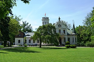
Oblęgorek is a village in the administrative district of Gmina Strawczyn, within Kielce County, Świętokrzyskie Voivodeship, in south-central Poland. It lies approximately 5 kilometres (3 mi) east of Strawczyn and 12 km (7 mi) north-west of the regional capital Kielce.
Promnik is a village in the administrative district of Gmina Strawczyn, within Kielce County, Świętokrzyskie Voivodeship, in south-central Poland. It lies approximately 3 kilometres (2 mi) south of Strawczyn and 15 km (9 mi) west of the regional capital Kielce.
Ruda Strawczyńska is a village in the administrative district of Gmina Strawczyn, within Kielce County, Świętokrzyskie Voivodeship, in south-central Poland. It lies approximately 4 kilometres (2 mi) west of Strawczyn and 19 km (12 mi) west of the regional capital Kielce.

Strawczyn is a village in Kielce County, Świętokrzyskie Voivodeship, in south-central Poland. It is the seat of the gmina called Gmina Strawczyn. It lies approximately 16 km (10 mi) north-west of the regional capital Kielce.
Strawczynek is a village in the administrative district of Gmina Strawczyn, within Kielce County, Świętokrzyskie Voivodeship, in south-central Poland. It lies approximately 2 kilometres (1 mi) east of Strawczyn and 14 km (9 mi) north-west of the regional capital Kielce.
Potok-Kolonia is a village in the administrative district of Gmina Ożarów, within Opatów County, Świętokrzyskie Voivodeship, in south-central Poland. It lies approximately 6 kilometres (4 mi) north of Ożarów, 22 km (14 mi) north-east of Opatów, and 73 km (45 mi) east of the regional capital Kielce.
Chocimów is a village in the administrative district of Gmina Kunów, within Ostrowiec County, Świętokrzyskie Voivodeship, in south-central Poland. It lies approximately 4 kilometres (2 mi) south-west of Kunów, 11 km (7 mi) west of Ostrowiec Świętokrzyski, and 45 km (28 mi) east of the regional capital Kielce.
Jastrząbki is a village in the administrative district of Gmina Janowiec Kościelny, within Nidzica County, Warmian-Masurian Voivodeship, in northern Poland. It lies approximately 3 kilometres (2 mi) north-west of Janowiec Kościelny, 8 km (5 mi) south-east of Nidzica, and 53 km (33 mi) south of the regional capital Olsztyn.


