A causeway is a track, road or railway on top of an embankment across "a low, or wet place, or piece of water". It can be constructed of earth, masonry, wood, or concrete. One of the earliest known wooden causeways is the Sweet Track in the Somerset Levels, England, that dates from the Neolithic age. Timber causeways may also be described as both boardwalks and bridges.

In geology, the places known as hotspots or hot spots are volcanic regions thought to be fed by underlying mantle that is anomalously hot compared with the surrounding mantle. Their position on the Earth's surface is independent of tectonic plate boundaries. There are two hypotheses that attempt to explain their origins. One suggests that hotspots are due to mantle plumes that rise as thermal diapirs from the core–mantle boundary. The other hypothesis is that lithospheric extension permits the passive rising of melt from shallow depths. This hypothesis considers the term "hotspot" to be a misnomer, asserting that the mantle source beneath them is, in fact, not anomalously hot at all. Well-known examples include the Hawaii, Iceland and Yellowstone hotspots.

The location of the geographical centre of Europe depends on the definition of the borders of Europe, mainly whether remote islands are included to define the extreme points of Europe, and on the method of calculating the final result. Thus, several places claim to host this hypothetical centre.

Greater Caucasus is the major mountain range of the Caucasus Mountains.

The European route E 22 is one of the longest European routes. It has a length of about 5,320 km (3,310 mi). Many of the E-roads have been extended into Asia since the year 2000; the E 22 was extended on 24 June 2002.
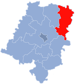
Rohov is a village in the Moravian-Silesian Region of the Czech Republic. It is part of micro-region Hlučínsko. It has around 600 inhabitants.

Pale-Prača is a town and municipality located in Bosnian-Podrinje Canton Goražde of the Federation of Bosnia and Herzegovina, an entity of Bosnia and Herzegovina. The main town of the municipality is Prača.

This is a list of the extreme points of Azerbaijan, the points that are farther north, south, east or west than any other location.

Advanced Landing Grounds (ALGs) were temporary advance airfields constructed by the Allies during World War II during the liberation of Europe. They were built in the UK prior to the invasion and thereafter in northwest Europe from 6 June 1944 to V-E Day, 7 May 1945.

This is a list of the extreme points of the Philippines, the points that are farther north, south, east or west than any other location in the country.
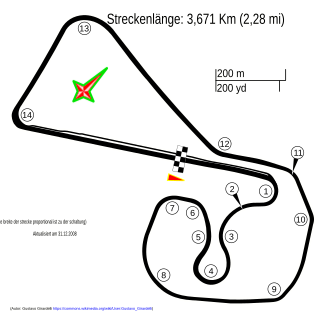
The 2008 German motorcycle Grand Prix was the tenth round of the 2008 MotoGP season. It took place on the weekend of 11–13 July 2008 at the Sachsenring, located in Hohenstein-Ernstthal, Germany.
Đào Mỹ is a commune (xã) and village in Lạng Giang District, Bắc Giang Province, in northeastern Vietnam.

TVN is a South Korean nationwide general entertainment network owned by CJ E&M, available on cable, SkyLife and IPTV platforms. Since 2014, the network is headed by Rhee Myung-han.
Alaca Dam is a dam in Çorum Province, Turkey, built between 1979 and 1984.

Bhor taluka is a taluka in Haveli subdivision of Pune district of state of Maharashtra in India.

Ozerkovići is a village in the municipality of Sokolac, Bosnia and Herzegovina.

The Fortuna Sittard Stadion is a multi-use stadium on the Milaanstraat, Sittard, Netherlands. Currently used mostly for football matches, it is the home stadium of Fortuna Sittard. Built on the site of an industrial estate in 1999, it replaced Fortuna Sittard's former stadium, De Baandert. In 2013 they began to expand the stadion with an extra sports centrum next to it, a new hotel in the stadium and an whole new look.