Nowa Sól County is a unit of territorial administration and local government (powiat) in Lubusz Voivodeship, western Poland. It came into being on January 1, 1999, as a result of the Polish local government reforms passed in 1998. Its administrative seat and largest town is Nowa Sól, which lies 22 km (14 mi) south-east of Zielona Góra and 109 km (68 mi) south of Gorzów Wielkopolski. The county contains three other towns: Kożuchów, lying 10 km (6 mi) south-west of Nowa Sól, Bytom Odrzański, lying 11 km (7 mi) south-east of Nowa Sól, and Nowe Miasteczko, 13 km (8 mi) south of Nowa Sól.

Puławy County is a unit of territorial administration and local government (powiat) in Lublin Voivodeship, eastern Poland. It was first established in 1867, but its current borders were established on January 1, 1999, as a result of the Polish local government reforms passed in 1998. Its administrative seat and largest town is Puławy, which lies 46 kilometres (29 mi) north-west of the regional capital Lublin. The county also contains the towns of Nałęczów, lying 23 km (14 mi) south-east of Puławy, and Kazimierz Dolny, 11 km (7 mi) south of Puławy.

Kraśnik County is a unit of territorial administration and local government (powiat) in Lublin Voivodeship, eastern Poland. It was established on January 1, 1999, as a result of the Polish local government reforms passed in 1998. Its administrative seat and largest town is Kraśnik, which lies 45 kilometres (28 mi) south-west of the regional capital Lublin. The only other town in the county is Annopol, lying 25 km (16 mi) west of Kraśnik.

Opole County is a unit of territorial administration and local government (powiat) in Lublin Voivodeship, eastern Poland. It was established on January 1, 1999, as a result of the Polish local government reforms passed in 1998. Its administrative seat is the town of Opole Lubelskie, which lies 44 kilometres (27 mi) west of the regional capital Lublin. The only other town in the county is Poniatowa, lying 8 km (5 mi) north-east of Opole Lubelskie.

Opatów County is a unit of territorial administration and local government (powiat) in Świętokrzyskie Voivodeship, south-central Poland. It came into being on January 1, 1999, as a result of the Polish local government reforms passed in 1998. Its administrative seat and largest town is Opatów, which lies 58 kilometres (36 mi) east of the regional capital Kielce. The only other town in the county is Ożarów, lying 20 km (12 mi) north-east of Opatów.

Wieluń County is a unit of territorial administration and local government (powiat) in Łódź Voivodeship, central Poland. It came into being on January 1, 1999, as a result of the Polish local government reforms passed in 1998. Its administrative seat and only town is Wieluń, which lies 88 kilometres (55 mi) south-west of the regional capital Łódź.

Lubliniec County is a unit of territorial administration and local government (powiat) in Silesian Voivodeship, southern Poland. It came into being on January 1, 1999, as a result of the Polish local government reforms passed in 1998. Its administrative seat and largest town is Lubliniec, which lies 54 kilometres (34 mi) north-west of the regional capital Katowice. The only other town in the county is Woźniki, lying 45 km (28 mi) north-east of Lubliniec.

Krapkowice County is a unit of territorial administration and local government (powiat) in Opole Voivodeship, south-western Poland. It came into being on January 1, 1999, as a result of the Polish local government reforms passed in 1998. Its administrative seat and largest town is Krapkowice, which lies 23 kilometres (14 mi) south of the regional capital Opole. The county also contains the towns of Zdzieszowice, lying 13 km (8 mi) south-east of Krapkowice, and Gogolin, 5 km (3 mi) north-east of Krapkowice.

Kluczbork County is a unit of territorial administration and local government (powiat) in Opole Voivodeship, south-western Poland. It came into being on January 1, 1999, as a result of the Polish local government reforms passed in 1998. Its administrative seat and largest town is Kluczbork, which lies 41 kilometres (25 mi) north-east of the regional capital Opole. The county also contains the towns of Wołczyn, lying 12 km (7 mi) west of Kluczbork, and Byczyna, 15 km (9 mi) north of Kluczbork.

Nysa County is a unit of territorial administration and local government (powiat) in Opole Voivodeship, south-western Poland, on the Czech border. It came into being on January 1, 1999, as a result of the Polish local government reforms passed in 1998. Its administrative seat and largest town is Nysa, which lies 48 kilometres (30 mi) south-west of the regional capital Opole. The county contains four other towns: Głuchołazy, 18 km (11 mi) south of Nysa, Paczków, 24 km (15 mi) west of Nysa, Otmuchów, 12 km (7 mi) west of Nysa, and Korfantów, 20 km (12 mi) east of Nysa.

Prudnik County is a unit of territorial administration and local government (powiat) in Opole Voivodeship, south-western Poland, on the Czech border. It came into being on January 1, 1999, as a result of the Polish local government reforms passed in 1998. Its administrative seat and largest town is Prudnik, which lies 46 kilometres (29 mi) south-west of the regional capital Opole. The county also contains the towns of Głogówek, lying 21 km (13 mi) east of Prudnik, and Biała, 11 km (7 mi) north-east of Prudnik.

Głubczyce County is a unit of territorial administration and local government (powiat) in Opole Voivodeship, south-western Poland, on the Czech border. It came into being on January 1, 1999, as a result of the Polish local government reforms passed in 1998. Its administrative seat and largest town is Głubczyce, which lies 53 kilometres (33 mi) south of the regional capital Opole. The county also contains the towns of Kietrz, lying 19 km (12 mi) south-east of Głubczyce, and Baborów, 12 km (7 mi) south-east of Głubczyce.

Strzelce County is a unit of territorial administration and local government (powiat) in Opole Voivodeship, south-western Poland. It came into being on January 1, 1999, as a result of the Polish local government reforms passed in 1998. Its administrative seat and largest town is Strzelce Opolskie, which lies 31 kilometres (19 mi) south-east of the regional capital Opole. The county contains four other towns: Zawadzkie, 19 km (12 mi) north-east of Strzelce Opolskie, Kolonowskie, 19 km (12 mi) north-east of Strzelce Opolskie, Leśnica, 11 km (7 mi) south-west of Strzelce Opolskie, and Ujazd, 14 km (9 mi) south-east of Strzelce Opolskie.

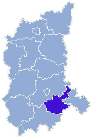
Opole County is a unit of territorial administration and local government (powiat) in Opole Voivodeship, south-western Poland. It came into being on January 1, 1999, as a result of the Polish local government reforms passed in 1998. Its administrative seat is the city of Opole, although the city is not part of the county. The county contains four towns: Ozimek, 20 km (12 mi) east of Opole, Niemodlin, 24 km (15 mi) west of Opole, Prószków, 11 km (7 mi) south-west of Opole, and Tułowice, 22 kilometres (14 mi) south-west of Opole.

Brzeg County is a unit of territorial administration and local government (powiat) in Opole Voivodeship, south-western Poland. It came into being on January 1, 1999, as a result of the Polish local government reforms passed in 1998. Its administrative seat and largest town is Brzeg, which lies 39 kilometres (24 mi) north-west of the regional capital Opole. The county also contains the towns of Grodków, lying 22 km (14 mi) south of Brzeg, and Lewin Brzeski, 17 km (11 mi) south-east of Brzeg.
Kłobuck County is a unit of territorial administration and local government (powiat) in Silesian Voivodeship, southern Poland. It came into being on January 1, 1999, as a result of the Polish local government reforms passed in 1998. Its administrative seat and largest town is Kłobuck, which lies 75 kilometres (47 mi) north of the regional capital Katowice. The only other town in the county is Krzepice, lying 16 km (10 mi) west of Kłobuck.
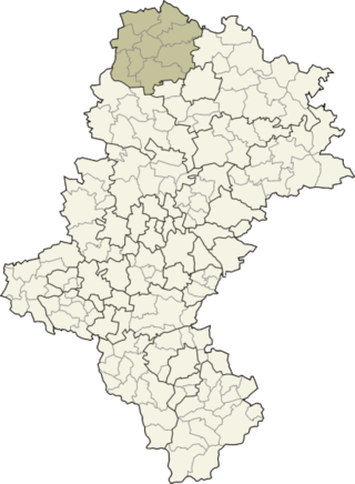
Gmina Gorzów Śląski is an urban-rural gmina in Olesno County, Opole Voivodeship, in south-western Poland. Its seat is the town of Gorzów Śląski, which lies approximately 18 kilometres (11 mi) north of Olesno and 54 km (34 mi) north-east of the regional capital Opole.
Gmina Praszka is an urban-rural gmina in Olesno County, Opole Voivodeship, in south-western Poland. Its seat is the town of Praszka, which lies approximately 20 kilometres (12 mi) north of Olesno and 56 km (35 mi) north-east of the regional capital Opole.
Gmina Radłów, German Gemeinde Radlau is a rural gmina in Olesno County, Opole Voivodeship, in south-western Poland. Its seat is the village of Radłów, which lies approximately 11 kilometres (7 mi) north-east of Olesno and 52 km (32 mi) north-east of the regional capital Opole.
Szyszków is a village in the administrative district of Gmina Praszka, within Olesno County, Opole Voivodeship, in south-western Poland. It lies approximately 3 kilometres (2 mi) south-west of Praszka, 18 km (11 mi) north of Olesno, and 54 km (34 mi) north-east of the regional capital Opole.