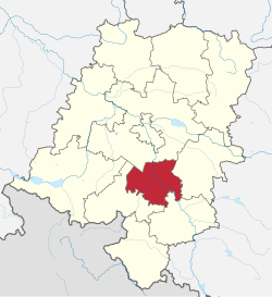
Krapkowice County

Last updated
Krapkowice County

Powiat krapkowicki
Locator map Krapkowice County in Opole Voivodeship.svg
Location within the voivodeship
Coordinates(Krapkowice): 50°28′N17°58′E / 50.467°N 17.967°E / 50.467; 17.967 Coordinates: 50°28′N17°58′E / 50.467°N 17.967°E / 50.467; 17.967
CountryFlag of Poland.svg  Poland
Voivodeship Opole
Seat Krapkowice
Gminas
Government
  Head of County Maciej Sonik
Area
  Total442.35 km2 (170.79 sq mi)
Population
 (2019-06-30 [1] )
  Total63,857
  Density140/km2 (370/sq mi)
   Urban
34,428
  Rural
29,429
Car plates OKR
Website http://www.powiatkrapkowicki.pl

Krapkowice County (Polish : powiat krapkowicki) is a unit of territorial administration and local government (powiat) in Opole Voivodeship, south-western Poland. It came into being on January 1, 1999, as a result of the Polish local government reforms passed in 1998. Its administrative seat and largest town is Krapkowice, which lies 23 kilometres (14 mi) south of the regional capital Opole. The county also contains the towns of Zdzieszowice, lying 13 km (8 mi) south-east of Krapkowice, and Gogolin, 5 km (3 mi) north-east of Krapkowice.

Contents

The county covers an area of 442.35 square kilometres (170.8 sq mi). As of 2006 its total population is 67,926, out of which the population of Krapkowice is 16,301, that of Zdzieszowice is 11,445, that of Gogolin is 6,682, and the rural population is 29,429.

Neighbouring counties

Krapkowice County is bordered by Opole County to the north, Strzelce County to the east, Kędzierzyn-Koźle County to the south-east and Prudnik County to the west.

Administrative division

The county is subdivided into five gminas (three urban-rural and two rural). These are listed in the following table, in descending order of population.

GminaTypeArea
(km2)
Population
(2019)
Seat
Gmina Krapkowice urban-rural97.422,656 Krapkowice
Gmina Zdzieszowice urban-rural57.915,740 Zdzieszowice
Gmina Gogolin urban-rural100.512,632 Gogolin
Gmina Strzeleczki rural117.37,391 Strzeleczki
Gmina Walce rural69.35,438 Walce

Related Research Articles

Lipsko County County in Masovian Voivodeship, Poland

Lipsko County is a unit of territorial administration and local government (powiat) in Masovian Voivodeship, east-central Poland. It came into being on January 1, 1999, as a result of the Polish local government reforms passed in 1998. Its administrative seat and only town is Lipsko, which lies 127 kilometres (79 mi) south of Warsaw.

Puławy County County in Lublin Voivodeship, Poland

Puławy County is a unit of territorial administration and local government (powiat) in Lublin Voivodeship, eastern Poland. It was first established in 1867, but its current borders were established on January 1, 1999, as a result of the Polish local government reforms passed in 1998. Its administrative seat and largest town is Puławy, which lies 46 kilometres (29 mi) north-west of the regional capital Lublin. The county also contains the towns of Nałęczów, lying 23 km (14 mi) south-east of Puławy, and Kazimierz Dolny, 11 km (7 mi) south of Puławy.

Lublin County County in Lublin Voivodeship, Poland

Lublin County is a unit of territorial administration and local government (powiat) in Lublin Voivodeship, eastern Poland. It was established on January 1, 1999, as a result of the Polish local government reforms passed in 1998. Its administrative seat is the city of Lublin, although the city is not part of the county. The only towns in Lublin County are Bełżyce, which lies 23 km (14 mi) west of Lublin, and Bychawa, 26 km (16 mi) south of Lublin.

Kraśnik County County in Lublin Voivodeship, Poland

Kraśnik County is a unit of territorial administration and local government (powiat) in Lublin Voivodeship, eastern Poland. It was established on January 1, 1999, as a result of the Polish local government reforms passed in 1998. Its administrative seat and largest town is Kraśnik, which lies 45 kilometres (28 mi) south-west of the regional capital Lublin. The only other town in the county is Annopol, lying 25 km (16 mi) west of Kraśnik.

Opole Lubelskie County County in Lublin Voivodeship, Poland

Opole Lubelskie County is a unit of territorial administration and local government (powiat) in Lublin Voivodeship, eastern Poland. It was established on January 1, 1999, as a result of the Polish local government reforms passed in 1998. Its administrative seat is the town of Opole Lubelskie, which lies 44 kilometres (27 mi) west of the regional capital Lublin. The only other town in the county is Poniatowa, lying 8 km (5 mi) north-east of Opole Lubelskie.

Opatów County County in Świętokrzyskie Voivodeship, Poland

Opatów County is a unit of territorial administration and local government (powiat) in Świętokrzyskie Voivodeship, south-central Poland. It came into being on January 1, 1999, as a result of the Polish local government reforms passed in 1998. Its administrative seat and largest town is Opatów, which lies 58 kilometres (36 mi) east of the regional capital Kielce. The only other town in the county is Ożarów, lying 20 km (12 mi) north-east of Opatów.

Kluczbork County County in Opole Voivodeship, Poland

Kluczbork County is a unit of territorial administration and local government (powiat) in Opole Voivodeship, south-western Poland. It came into being on January 1, 1999, as a result of the Polish local government reforms passed in 1998. Its administrative seat and largest town is Kluczbork, which lies 41 kilometres (25 mi) north-east of the regional capital Opole. The county also contains the towns of Wołczyn, lying 12 km (7 mi) west of Kluczbork, and Byczyna, 15 km (9 mi) north of Kluczbork.

Nysa County County in Opole Voivodeship, Poland

Nysa County is a unit of territorial administration and local government (powiat) in Opole Voivodeship, south-western Poland, on the Czech border. It came into being on January 1, 1999, as a result of the Polish local government reforms passed in 1998. Its administrative seat and largest town is Nysa, which lies 48 kilometres (30 mi) south-west of the regional capital Opole. The county contains four other towns: Głuchołazy, 18 km (11 mi) south of Nysa, Paczków, 24 km (15 mi) west of Nysa, Otmuchów, 12 km (7 mi) west of Nysa, and Korfantów, 20 km (12 mi) east of Nysa.

Olesno County County in Opole Voivodeship, Poland

Olesno County is a unit of territorial administration and local government (powiat) in Opole Voivodeship, south-western Poland. It came into being on January 1, 1999, as a result of the Polish local government reforms passed in 1998. Its administrative seat and largest town is Olesno, which lies 42 kilometres (26 mi) north-east of the regional capital Opole. The county contains three other towns: Praszka, 20 km (12 mi) north of Olesno, Dobrodzień, 17 km (11 mi) south of Olesno, and Gorzów Śląski, 18 km (11 mi) north of Olesno.

Prudnik County County in Opole Voivodeship, Poland

Prudnik County is a unit of territorial administration and local government (powiat) in Opole Voivodeship, south-western Poland, on the Czech border. It came into being on January 1, 1999, as a result of the Polish local government reforms passed in 1998. Its administrative seat and largest town is Prudnik, which lies 46 kilometres (29 mi) south-west of the regional capital Opole. The county also contains the towns of Głogówek, lying 21 km (13 mi) east of Prudnik, and Biała Prudnicka, 11 km (7 mi) north-east of Prudnik.

Namysłów County County in Opole Voivodeship, Poland

Namysłów County is a unit of territorial administration and local government (powiat) in Opole Voivodeship, south-western Poland. It came into being on January 1, 1999, as a result of the Polish local government reforms passed in 1998. Its administrative seat and only town is Namysłów, which lies 48 kilometres (30 mi) north of the regional capital, which is the city of Opole.

Strzelce County County in Opole Voivodeship, Poland

Strzelce County is a unit of territorial administration and local government (powiat) in Opole Voivodeship, south-western Poland. It came into being on January 1, 1999, as a result of the Polish local government reforms passed in 1998. Its administrative seat and largest town is Strzelce Opolskie, which lies 31 kilometres (19 mi) south-east of the regional capital Opole. The county contains four other towns: Zawadzkie, 19 km (12 mi) north-east of Strzelce Opolskie, Kolonowskie, 19 km (12 mi) north-east of Strzelce Opolskie, Leśnica, 11 km (7 mi) south-west of Strzelce Opolskie, and Ujazd, 14 km (9 mi) south-east of Strzelce Opolskie.

Opole County County in Opole Voivodeship, Poland

Opole County is a unit of territorial administration and local government (powiat) in Opole Voivodeship, south-western Poland. It came into being on January 1, 1999, as a result of the Polish local government reforms passed in 1998. Its administrative seat is the city of Opole, although the city is not part of the county. The county contains four towns: Ozimek, 20 km (12 mi) east of Opole, Niemodlin, 24 km (15 mi) west of Opole, Prószków, 11 km (7 mi) south-west of Opole, and Tułowice, 22 kilometres (14 mi) south-west of Opole.

Kędzierzyn-Koźle County County in Opole Voivodeship, Poland

Kędzierzyn-Koźle County is a unit of territorial administration and local government (powiat) in Opole Voivodeship, south-western Poland. It came into being on January 1, 1999, as a result of the Polish local government reforms passed in 1998. Its administrative seat and only town is Kędzierzyn-Koźle, which lies 40 kilometres (25 mi) south-east of the regional capital Opole.

Brzeg County County in Opole Voivodeship, Poland

Brzeg County is a unit of territorial administration and local government (powiat) in Opole Voivodeship, south-western Poland. It came into being on January 1, 1999, as a result of the Polish local government reforms passed in 1998. Its administrative seat and largest town is Brzeg, which lies 39 kilometres (24 mi) north-west of the regional capital Opole. The county also contains the towns of Grodków, lying 22 km (14 mi) south of Brzeg, and Lewin Brzeski, 17 km (11 mi) south-east of Brzeg.

Gmina Krapkowice Gmina in Opole Voivodeship, Poland

Gmina Krapkowice is an urban-rural gmina in Krapkowice County, Opole Voivodeship, in south-western Poland. Its seat is the town of Krapkowice, which lies approximately 23 kilometres (14 mi) south of the regional capital Opole.

Gmina Gogolin is an urban-rural gmina in Krapkowice County, Opole Voivodeship, in south-western Poland. Its seat is the town of Gogolin, which lies approximately 5 kilometres (3 mi) north-east of Krapkowice and 21 km (13 mi) south of the regional capital Opole.

Gmina Strzeleczki, German Gemeinde Klein Strehlitz is a rural gmina in Krapkowice County, Opole Voivodeship, in south-western Poland. Its seat is the village of Strzeleczki, which lies approximately 8 kilometres (5 mi) west of Krapkowice and 23 km (14 mi) south of the regional capital Opole.

Gmina Walce, German Gemeinde Walzen is a rural gmina in Krapkowice County, Opole Voivodeship, in south-western Poland. Its seat is the village of Walce (Walzen), which lies approximately 11 kilometres (7 mi) south of Krapkowice and 34 km (21 mi) south of the regional capital Opole.

Gmina Zdzieszowice is an urban-rural gmina in Krapkowice County, Opole Voivodeship, in south-western Poland. Its seat is the town of Zdzieszowice, which lies approximately 13 kilometres (8 mi) south-east of Krapkowice and 31 km (19 mi) south-east of the regional capital Opole.

References

  1. "Population. Size and structure and vital statistics in Poland by territorial division in 2019. As of 30th June". stat.gov.pl. Statistics Poland. 2019-10-15. Retrieved 2020-02-14.