Gmina Gogolin

Last updated
Gmina Gogolin
Gogolin Commune
Gmina
POL Gogolin flag.svg
Flag
POL Gogolin COA.svg
Coat of arms
Coordinates(Gogolin): 50°29′17″N18°1′26″E / 50.48806°N 18.02389°E / 50.48806; 18.02389 Coordinates: 50°29′17″N18°1′26″E / 50.48806°N 18.02389°E / 50.48806; 18.02389
CountryFlag of Poland.svg  Poland
Voivodeship Opole
County Krapkowice
Seat Gogolin
Area
  Total 100.51 km2 (38.81 sq mi)
Population (2006)
  Total 11,932
  Density 120/km2 (310/sq mi)
   Urban 6,077
  Rural 5,855
Website http://www.gogolin.pl/

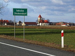
Gmina Gogolin is an urban-rural gmina (administrative district) in Krapkowice County, Opole Voivodeship, in south-western Poland. Its seat is the town of Gogolin, which lies approximately 5 kilometres (3 mi) north-east of Krapkowice and 21 km (13 mi) south of the regional capital Opole.

Gmina administrative division of Poland

The gmina is the principal unit of the administrative division of Poland, similar to a municipality. As of 2010 there were 2,478 gminy throughout the country. The word gmina derives from the German word Gemeinde, meaning "community".

Krapkowice County County in Opole, Poland

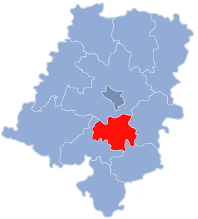
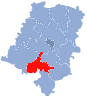
Krapkowice County is a unit of territorial administration and local government (powiat) in Opole Voivodeship, south-western Poland. It came into being on January 1, 1999, as a result of the Polish local government reforms passed in 1998. Its administrative seat and largest town is Krapkowice, which lies 23 kilometres (14 mi) south of the regional capital Opole. The county also contains the towns of Zdzieszowice, lying 13 km (8 mi) south-east of Krapkowice, and Gogolin, 5 km (3 mi) north-east of Krapkowice.

Opole Voivodeship Voivodeship in Poland

Opole Voivodeship, or Opole Province, is the smallest and least populated voivodeship (province) of Poland. The province's name derives from that of the region's capital and largest city, Opole. It is part of Upper Silesia. A relatively large German minority, with representatives in the Sejm, lives in the voivodeship, and the German language is co-official in 28 communes.

Contents

The gmina covers an area of 100.51 square kilometres (38.8 sq mi), and as of 2006 its total population is 11,932 (out of which the population of Gogolin amounts to 6,077, and the population of the rural part of the gmina is 5,855).

The gmina contains part of the protected area called Góra Świętej Anny Landscape Park.

Protected area location which receives protection because of its recognised natural, ecological or cultural landscape values

Protected areas or conservation areas are locations which receive protection because of their recognized natural, ecological or cultural values. There are several kinds of protected areas, which vary by level of protection depending on the enabling laws of each country or the regulations of the international organizations involved.

Góra Świętej Anny Landscape Park

Góra Świętej Anny Landscape Park is a protected area in south-western Poland, established in 1988, covering an area of 50.50 square kilometres (19.50 sq mi).

Villages

Apart from the town of Gogolin, Gmina Gogolin contains the villages and settlements of Chorula, Dąbrówka, Górażdże, Kamień Śląski, Kamionek, Malnia, Obrowiec, Odrowąż and Zakrzów.

Chorula Village in Opole, Poland

Chorula is a village in the administrative district of Gmina Gogolin, within Krapkowice County, Opole Voivodeship, in south-western Poland. It lies approximately 7 kilometres (4 mi) north-west of Gogolin, 8 km (5 mi) north of Krapkowice, and 15 km (9 mi) south of the regional capital Opole.

Dąbrówka, Opole Voivodeship Village in Opole, Poland

Dąbrówka is a village in the administrative district of Gmina Gogolin, within Krapkowice County, Opole Voivodeship, in south-western Poland.

Górażdże Village in Opole, Poland

Górażdże is a village in the administrative district of Gmina Gogolin, within Krapkowice County, Opole Voivodeship, in south-western Poland. It lies approximately 6 kilometres (4 mi) north of Gogolin, 9 km (6 mi) north-east of Krapkowice, and 16 km (10 mi) south of the regional capital Opole.

Neighbouring gminas

Gmina Gogolin is bordered by the gminas of Izbicko, Krapkowice, Strzelce Opolskie, Strzeleczki, Tarnów Opolski and Zdzieszowice.

Gmina Izbicko Gmina in Opole, Poland

Gmina Izbicko, German Gemeinde Stubendorf, is a rural gmina in Strzelce County, Opole Voivodeship, in south-western Poland. Its seat is the village of Izbicko, which lies approximately 14 kilometres (9 mi) north-west of Strzelce Opolskie and 18 km (11 mi) south-east of the regional capital Opole.

Gmina Krapkowice is an urban-rural gmina in Krapkowice County, Opole Voivodeship, in south-western Poland. Its seat is the town of Krapkowice, which lies approximately 23 kilometres (14 mi) south of the regional capital Opole.

Gmina Strzelce Opolskie Gmina in Opole, Poland

Gmina Strzelce Opolskie is an urban-rural gmina in Strzelce County, Opole Voivodeship, in south-western Poland. Its seat is the town of Strzelce Opolskie, which lies approximately 31 kilometres (19 mi) south-east of the regional capital Opole.

Related Research Articles

Prudnik County County in Opole, Poland

Prudnik County is a unit of territorial administration and local government (powiat) in Opole Voivodeship, south-western Poland, on the Czech border. It came into being on January 1, 1999, as a result of the Polish local government reforms passed in 1998. Its administrative seat and largest town is Prudnik, which lies 46 kilometres (29 mi) south-west of the regional capital Opole. The county also contains the towns of Głogówek, lying 21 km (13 mi) east of Prudnik, and Biała Prudnicka, 11 km (7 mi) north-east of Prudnik.

Strzelce County County in Opole, Poland

Strzelce County is a unit of territorial administration and local government (powiat) in Opole Voivodeship, south-western Poland. It came into being on January 1, 1999, as a result of the Polish local government reforms passed in 1998. Its administrative seat and largest town is Strzelce Opolskie, which lies 31 kilometres (19 mi) south-east of the regional capital Opole. The county contains four other towns: Zawadzkie, 19 km (12 mi) north-east of Strzelce Opolskie, Kolonowskie, 19 km (12 mi) north-east of Strzelce Opolskie, Leśnica, 11 km (7 mi) south-west of Strzelce Opolskie, and Ujazd, 14 km (9 mi) south-east of Strzelce Opolskie.

Opole County County in Opole, Poland

Opole County is a unit of territorial administration and local government (powiat) in Opole Voivodeship, south-western Poland. It came into being on January 1, 1999, as a result of the Polish local government reforms passed in 1998. Its administrative seat is the city of Opole, although the city is not part of the county. The county contains three towns: Ozimek, 20 km (12 mi) east of Opole, Niemodlin, 24 km (15 mi) west of Opole, and Prószków, 11 km (7 mi) south-west of Opole.

Kędzierzyn-Koźle County County in Opole, Poland

Kędzierzyn-Koźle County is a unit of territorial administration and local government (powiat) in Opole Voivodeship, south-western Poland. It came into being on January 1, 1999, as a result of the Polish local government reforms passed in 1998. Its administrative seat and only town is Kędzierzyn-Koźle, which lies 40 kilometres (25 mi) south-east of the regional capital Opole.

Gmina Strzeleczki, German Gemeinde Klein Strehlitz is a rural gmina in Krapkowice County, Opole Voivodeship, in south-western Poland. Its seat is the village of Strzeleczki, which lies approximately 8 kilometres (5 mi) west of Krapkowice and 23 km (14 mi) south of the regional capital Opole.

Gmina Walce, German Gemeinde Walzen is a rural gmina in Krapkowice County, Opole Voivodeship, in south-western Poland. Its seat is the village of Walce (Walzen), which lies approximately 11 kilometres (7 mi) south of Krapkowice and 34 km (21 mi) south of the regional capital Opole.

Gmina Zdzieszowice is an urban-rural gmina in Krapkowice County, Opole Voivodeship, in south-western Poland. Its seat is the town of Zdzieszowice, which lies approximately 13 kilometres (8 mi) south-east of Krapkowice and 31 km (19 mi) south-east of the regional capital Opole.

Gmina Tarnów Opolski, German Gemeinde Tarnau is a rural gmina in Opole County, Opole Voivodeship, in south-western Poland. Its seat is the village of Tarnów Opolski (Tarnau), which lies approximately 15 kilometres (9 mi) south-east of the regional capital Opole.

Gmina Głogówek, German Gemeinde Oberglogau is an urban-rural gmina in Prudnik County, Opole Voivodeship, in south-western Poland, on the Czech border in Upper Silesia. Its seat is the town of Głogówek (Oberglogau), which lies approximately 21 kilometres (13 mi) east of Prudnik and 37 km (23 mi) south of the regional capital Opole.

Kamień Śląski Village in Opole, Poland

Kamień Śląski is a village in the administrative district of Gmina Gogolin, within Krapkowice County, Opole Voivodeship, in south-western Poland. It lies approximately 9 kilometres (6 mi) north-east of Gogolin, 13 km (8 mi) north-east of Krapkowice, and 17 km (11 mi) south-east of the regional capital Opole.

Kamionek, Opole Voivodeship Village in Opole, Poland

Kamionek is a village in the administrative district of Gmina Gogolin, within Krapkowice County, Opole Voivodeship, in south-western Poland. It lies approximately 6 kilometres (4 mi) north-east of Gogolin, 10 km (6 mi) north-east of Krapkowice, and 19 km (12 mi) south-east of the regional capital Opole.

Malnia Village in Opole, Poland

Malnia is a village in the administrative district of Gmina Gogolin, within Krapkowice County, Opole Voivodeship, in south-western Poland. It lies approximately 6 kilometres (4 mi) north-west of Gogolin, 6 km (4 mi) north of Krapkowice, and 17 km (11 mi) south of the regional capital Opole.

Obrowiec, Opole Voivodeship Village in Opole, Poland

Obrowiec is a village in the administrative district of Gmina Gogolin, within Krapkowice County, Opole Voivodeship, in south-western Poland. It lies approximately 5 kilometres (3 mi) south of Gogolin, 4 km (2 mi) south-east of Krapkowice, and 25 km (16 mi) south of the regional capital Opole.

Odrowąż, Opole Voivodeship Village in Opole, Poland

Odrowąż is a village in the administrative district of Gmina Gogolin, within Krapkowice County, Opole Voivodeship, in south-western Poland. It lies approximately 6 kilometres (4 mi) west of Gogolin, 4 km (2 mi) north of Krapkowice, and 19 km (12 mi) south of the regional capital Opole.

References