
Opole Voivodeship, or Opole Province, is the smallest and least populated voivodeship (province) of Poland. The province's name derives from that of the region's capital and largest city, Opole. It is part of Upper Silesia. A relatively large German minority lives in the voivodeship, and the German language is co-official in 28 communes.

Ząbkowice Śląskie County is a unit of territorial administration and local government (powiat) in Lower Silesian Voivodeship, south-western Poland. It came into being on January 1, 1999, as a result of the Polish local government reforms passed in 1998. The county covers an area of 801.75 square kilometres (309.6 sq mi). Its administrative seat is Ząbkowice Śląskie, and it also contains the towns of Ziębice, Złoty Stok and Bardo.
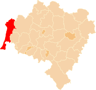
Zgorzelec County is a unit of territorial administration and local government (powiat) in Lower Silesian Voivodeship, Poland. It came into being on January 1, 1999, as a result of the Polish local government reforms passed in 1998. It is situated in the extreme south-west of Poland, bordering both Germany and the Czech Republic. The county covers an area of 838.1 square kilometres (323.6 sq mi). Its administrative seat is Zgorzelec, on the German border; the other towns in the county are Bogatynia, Pieńsk, Zawidów and Węgliniec.

Puławy County is a unit of territorial administration and local government (powiat) in Lublin Voivodeship, eastern Poland. It was first established in 1867, but its current borders were established on January 1, 1999, as a result of the Polish local government reforms passed in 1998. Its administrative seat and largest town is Puławy, which lies 46 kilometres (29 mi) north-west of the regional capital Lublin. The county also contains the towns of Nałęczów, lying 23 km (14 mi) south-east of Puławy, and Kazimierz Dolny, 11 km (7 mi) south of Puławy.

Opole County is a unit of territorial administration and local government (powiat) in Lublin Voivodeship, eastern Poland. It was established on January 1, 1999, as a result of the Polish local government reforms passed in 1998. Its administrative seat is the town of Opole Lubelskie, which lies 44 kilometres (27 mi) west of the regional capital Lublin. The only other town in the county is Poniatowa, lying 8 km (5 mi) north-east of Opole Lubelskie.

Opatów County is a unit of territorial administration and local government (powiat) in Świętokrzyskie Voivodeship, south-central Poland. It came into being on January 1, 1999, as a result of the Polish local government reforms passed in 1998. Its administrative seat and largest town is Opatów, which lies 58 kilometres (36 mi) east of the regional capital Kielce. The only other town in the county is Ożarów, lying 20 km (12 mi) north-east of Opatów.

Krapkowice County is a unit of territorial administration and local government (powiat) in Opole Voivodeship, south-western Poland. It came into being on January 1, 1999, as a result of the Polish local government reforms passed in 1998. Its administrative seat and largest town is Krapkowice, which lies 23 kilometres (14 mi) south of the regional capital Opole. The county also contains the towns of Zdzieszowice, lying 13 km (8 mi) south-east of Krapkowice, and Gogolin, 5 km (3 mi) north-east of Krapkowice.

Kluczbork County is a unit of territorial administration and local government (powiat) in Opole Voivodeship, south-western Poland. It came into being on January 1, 1999, as a result of the Polish local government reforms passed in 1998. Its administrative seat and largest town is Kluczbork, which lies 41 kilometres (25 mi) north-east of the regional capital Opole. The county also contains the towns of Wołczyn, lying 12 km (7 mi) west of Kluczbork, and Byczyna, 15 km (9 mi) north of Kluczbork.

Olesno County is a unit of territorial administration and local government (powiat) in Opole Voivodeship, south-western Poland. It came into being on January 1, 1999, as a result of the Polish local government reforms passed in 1998. Its administrative seat and largest town is Olesno, which lies 42 kilometres (26 mi) north-east of the regional capital Opole. The county contains three other towns: Praszka, 20 km (12 mi) north of Olesno, Dobrodzień, 17 km (11 mi) south of Olesno, and Gorzów Śląski, 18 km (11 mi) north of Olesno.

Prudnik County is a unit of territorial administration and local government (powiat) in Opole Voivodeship, south-western Poland, on the Czech border. It came into being on January 1, 1999, as a result of the Polish local government reforms passed in 1998. Its administrative seat and largest town is Prudnik, which lies 46 kilometres (29 mi) south-west of the regional capital Opole. The county also contains the towns of Głogówek, lying 21 km (13 mi) east of Prudnik, and Biała, 11 km (7 mi) north-east of Prudnik.

Głubczyce County is a unit of territorial administration and local government (powiat) in Opole Voivodeship, south-western Poland, on the Czech border. It came into being on January 1, 1999, as a result of the Polish local government reforms passed in 1998. Its administrative seat and largest town is Głubczyce, which lies 53 kilometres (33 mi) south of the regional capital Opole. The county also contains the towns of Kietrz, lying 19 km (12 mi) south-east of Głubczyce, and Baborów, 12 km (7 mi) south-east of Głubczyce.
Namysłów County is a unit of territorial administration and local government (powiat) in Opole Voivodeship, south-western Poland. It came into being on January 1, 1999, as a result of the Polish local government reforms passed in 1998. Its administrative seat and only town is Namysłów, which lies 48 kilometres (30 mi) north of the regional capital, which is the city of Opole.

Strzelce County is a unit of territorial administration and local government (powiat) in Opole Voivodeship, south-western Poland. It came into being on January 1, 1999, as a result of the Polish local government reforms passed in 1998. Its administrative seat and largest town is Strzelce Opolskie, which lies 31 kilometres (19 mi) south-east of the regional capital Opole. The county contains four other towns: Zawadzkie, 19 km (12 mi) north-east of Strzelce Opolskie, Kolonowskie, 19 km (12 mi) north-east of Strzelce Opolskie, Leśnica, 11 km (7 mi) south-west of Strzelce Opolskie, and Ujazd, 14 km (9 mi) south-east of Strzelce Opolskie.

Opole County is a unit of territorial administration and local government (powiat) in Opole Voivodeship, south-western Poland. It came into being on January 1, 1999, as a result of the Polish local government reforms passed in 1998. Its administrative seat is the city of Opole, although the city is not part of the county. The county contains four towns: Ozimek, 20 km (12 mi) east of Opole, Niemodlin, 24 km (15 mi) west of Opole, Prószków, 11 km (7 mi) south-west of Opole, and Tułowice, 22 kilometres (14 mi) south-west of Opole.

Brzeg County is a unit of territorial administration and local government (powiat) in Opole Voivodeship, south-western Poland. It came into being on January 1, 1999, as a result of the Polish local government reforms passed in 1998. Its administrative seat and largest town is Brzeg, which lies 39 kilometres (24 mi) north-west of the regional capital Opole. The county also contains the towns of Grodków, lying 22 km (14 mi) south of Brzeg, and Lewin Brzeski, 17 km (11 mi) south-east of Brzeg.
Gmina Nysa is an urban-rural gmina in Nysa County, Opole Voivodeship, in south-western Poland. Its seat is the town of Nysa, which lies approximately 48 kilometres (30 mi) south-west of the regional capital Opole.
Gmina Głuchołazy is an urban-rural gmina in Nysa County, Opole Voivodeship, in south-western Poland, on the Czech border. Its seat is the town of Głuchołazy, which lies approximately 18 kilometres (11 mi) south of Nysa and 56 km (35 mi) south-west of the regional capital Opole.

Gmina Otmuchów is an urban-rural gmina in Nysa County, Opole Voivodeship, in south-western Poland, on the Czech border. Its seat is the town of Otmuchów, which lies approximately 12 kilometres (7 mi) west of Nysa and 59 km (37 mi) south-west of the regional capital Opole.
Gmina Paczków is an urban-rural gmina in Nysa County, Opole Voivodeship, in south-western Poland, on the Czech border. Its seat is the town of Paczków, which lies approximately 24 kilometres (15 mi) west of Nysa and 71 km (44 mi) west of the regional capital Opole.
Gmina Prudnik is an urban-rural gmina in Prudnik County, Opole Voivodeship, in south-western Poland, on the Czech border. Its seat is the town of Prudnik, which lies approximately 46 kilometres (29 mi) south-west of the regional capital Opole.


