Related Research Articles

The Town of Cambridge is a local government area in the inner western suburbs of the Western Australian capital city of Perth, about 5 kilometres (3 mi) west of Perth's central business district and extending to the Indian Ocean at City Beach. The Town covers an area of 22.0 square kilometres (8.5 sq mi) and had a population of almost 27,000 as at the 2016 Census. It was originally part of the City of Perth before the restructuring by the Western Australian State Government in 1994.

Roleystone is a suburb of Perth, Western Australia in the south eastern corridor.

Wagin is a town and shire in the Wheatbelt region of Western Australia, approximately 225 km (139.81 mi) south-east of Perth on the Great Southern Highway between Narrogin and Katanning. It is also on State Route 107. The main industries are wheat and sheep farming.

Crawley is an affluent western suburb of Perth, the capital city of Western Australia. Whole area is part of the local government area of the City of Perth and previously shared between the City of Subiaco and City of Perth. It is about 5.8 kilometres (4 mi) from the Perth CBD via Mounts Bay Road.

Jarrahdale is a small historic town located 45 km south-east of Perth, Western Australia in the Darling Range. The name is derived from its situation in a jarrah forest. Established in the late 1800s as the state's first major timber milling operation, it played a key role in the development of Western Australia through the exportation of jarrah around the world. At the 2016 census, Jarrahdale had a population of 1,192. Since 2001, the historic precinct has been managed by the state's National Trust organisation alongside private residential and tourism-oriented developments.

The City of Perth is a local government area and body, within the Perth metropolitan area, which is the capital of Western Australia. The local government is commonly known as Perth City Council. The City covers the Perth city centre and surrounding suburbs. The City covers an area of 20.01 square kilometres (8 sq mi) and had an estimated population of 21,092 as at 30 June 2015. On 1 July 2016 the City expanded, absorbing 1,247 residents from the City of Subiaco.

A coffee palace was an often large and elaborate residential hotel that did not serve alcohol, most of which were built in Australia in the late 19th century.

The City of Subiaco is a local government area in Western Australia. It covers an area of approximately 7 km² in inner western metropolitan Perth and lies about 3 km west of the Perth CBD. The City includes the historically working-class suburb of Subiaco centred around Rokeby Road. Since the 1990s the area has been extensively redeveloped and gentrified.
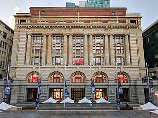
The General Post Office is a heritage landmark building in Perth, Western Australia. Located on the western side of Forrest Place in the city's central business district, its imposing stone facade is in the Beaux-Arts style. The building was completed in 1923 after almost a decade of construction, which was protracted by World War I and the resulting shortages of construction materials. At the time of its opening, it was the largest building in Perth.
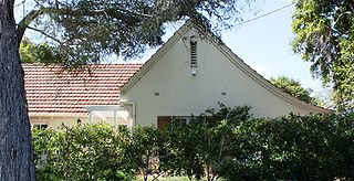
Model Timber Home is the name, for heritage-listing purposes, of a timber-framed house in Floreat, Western Australia. Designed by Reginald Summerhayes, the plans won a competition for the design of an ideal cheap modern timber-framed home. The house was subsequently built on donated land, using donated materials and labour in 1934.
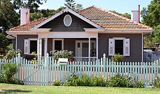
Model Brick Home is the name, for heritage-listing purposes, of a brick-and-tile house in Floreat, Western Australia. Designed by H. Howard Bonner in 1932, the plans won a competition for the design of an ideal cheap modern brick home; and the house was subsequently built on donated land, from donated materials and labour in 1934.
Iwan Iwanoff also known as Iwan Nickolow and Iwan Nickoloff Iwanoff, born in Kyustendil, Bulgaria and died in Perth, Western Australia, was an architect known for working in the Brutalist style. Iwan Iwanoff studied architecture in Europe before arriving in Perth to work as an architect. He became renowned for his design characteristic which is mainly working with concrete blocks.

The Pensioner Guards were English military personnel who served on convict transportation ships en route to the Swan River Colony between 1850 and 1868, and were given employment and grants of land on arrival. Their initial employment lasted for six months, or the duration of the voyage, whichever was the longer time. After this they became "pensioners" and had to serve 12 days per year as well as whenever called upon. They paraded annually in Perth at the Pensioner Barracks. Part of their purpose was to fulfil a promise by the British government to send free settlers to the colony to dilute the convicts, and to maintain law and order in the colony.

The former Toodyay Court House in Toodyay, Western Australia has been used as municipal offices for Toodyay since the 1950s.
This is a list of newspapers published in, or for, the Goldfields-Esperance region of Western Australia.

The Beverley Times is a defunct English language newspaper that was published weekly in the Wheatbelt town of Beverley, Western Australia, between 1905 and 1977.
Toodyay pioneer heritage trail was a trail created by the Toodyay Bicentennial Community Committee in 1988 for the Australian Bicentenary as part of the W.A. Heritage Trails Network.
Kings Park Road is situated in West Perth in Western Australia. It was once known as Brooking Street. It runs as a boundary between the suburbs of West Perth and Kings Park, from the west end of Malcolm Street to the corner of Bagot Road, Subiaco and Thomas Street, West Perth.

Cape Leeuwin water wheel, sometimes called the petrified water wheel, is a non-operating water wheel, near Cape Leeuwin, in the south-west of Western Australia. It was used to pump fresh water to the Cape Leeuwin Lighthouse. It is notable both for its coastal location and because it has become heavily calcified. The water wheel is located above a small cove, approximately 400m to the north of the Cape Leeuwin Lighthouse cottages. The base of the water wheel structure is just above the high-tide sea level.
References
- ↑ https://purl.slwa.wa.gov.au/slwa_b2661051_1 Model Homes Committee picture
- ↑ State Records of western Australia collection:AU WA S72- cons3054 1941/0029 Title:Endowment lands - sale of land at Floreat Park & model homes scheme
- ↑ "MODEL HOMES". Kalgoorlie Miner . Vol. 39, no. 9824. Western Australia. 5 September 1933. p. 5. Retrieved 4 October 2021– via National Library of Australia.
- ↑ "MODEL HOMES SCHEME". The West Australian . Vol. XLIX, no. 9, 741. Western Australia. 18 September 1933. p. 12. Retrieved 4 October 2021– via National Library of Australia.
- ↑ "Model Homes Competition". The West Australian . Vol. XLIX, no. 9, 753. Western Australia. 2 October 1933. p. 7. Retrieved 4 October 2021– via National Library of Australia.
- ↑ "Model Timber Home" (PDF). Register of Heritage Places — Assessment Documentation. Heritage Council of Western Australia. Archived from the original (PDF) on 30 June 2009. Retrieved 18 March 2009.
| | This Western Australia article is a stub. You can help Wikipedia by expanding it. |