Busan, officially Busan Metropolitan City, is South Korea's second most populous city after Seoul, with a population of over 3.4 million inhabitants as of 2017. Formerly romanized as Pusan, it is the economic, cultural and educational center of southeastern South Korea, with its port being South Korea's busiest and the sixth-busiest in the world. The surrounding "Southeastern Maritime Industrial Region" is South Korea's largest industrial area. The large volumes of port traffic and urban population in excess of 1 million make Busan a Large-Port metropolis using the Southampton System of Port-City classification.
Bundang-gu (Korean: 분당구) is the largest and most populous district (gu) of Seongnam, a major city in the Seoul Capital Area, South Korea. Bundang-gu is one of South Korea's wealthiest and highest developed areas, being the nation's first and largest completely artificial city built in the early 1990s. Many high-rise luxury condos moved in the early 2000s, with a second planned city built in the late 2000s called Pangyo in the same district. Apartment prices are the second highest in Gyeonggi-do after Gwacheon and 7th highest nationwide, higher than many central Seoul districts such as Mapo-gu or Jongno-gu. Apartments around Pangyo station and the high-rise luxury condos around Jeongja station and Sunae station rival prices in the most expensive areas in the country. Unlike older cities such as Seoul, Bundang has no telephone poles overground, resulting in a clean cityscape with well-designed streets.

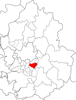
Buk District is a district in northwestern Daegu, South Korea. It adjoins Chilgok County on the north. The area is 93.99 km². The population is about 444,923.
Hyundai Department Store (Korean: 현대백화점) is a major department store chain in South Korea. Its parent company is the Hyundai Department Store Group. It, Lotte Department Store, and Shinsegae are the three largest chains in the country.
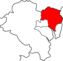
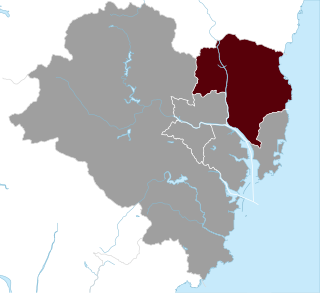
Buk District is a gu, or district, in north central Busan, South Korea. Buk-gu covers a surface of 38.30 km² is home to about 335,000 people. It attained the status of gu in 1978.
Gangseo District is a gu on the west side of Nakdong River in Busan, South Korea. It has an area of 179.05 km², and a population of about 66,000; it has a lower population density than Gijang county of Busan. Gangseo-gu was part of Buk-gu from its creation in 1978 to 1989 when it became an independent gu.

Jeongja-dong (Korean: 정자동) is a neighbourhood in the Bundang-gu district of Seongnam, Gyeonggi-do, South Korea. It is further subdivided into Jeongja 1-dong through Jeongja 3-dong.

Gangdong District (Gangdong-gu) is one of the 25 gu which makes up the city of Seoul. Gangdong, literally means "east of river".

Gwangjin District is one of the 25 districts of Seoul, South Korea. It is located on the north bank of the Han River on the eastern end of Seoul. The district was split from the neighboring Seongdong District in 1995.

Jung District is a gu in southern central Ulsan, South Korea. Its name literally means "Central Ward". Most of the population live between the southern border of the River Taehwa and Ring Road. The current head of the district is Park Sung-min (2018).

Bupyeong District is one of the 10 administrative divisions that comprise Incheon, South Korea. Bupyeong-gu comprises an area of 12.35 square miles, and has a population of 508,587. It is located north of Namdong-gu, east of Seo-gu, and south of Gyeyang-gu. The city of Bucheon, in neighboring Gyeonggi Province, comprises its eastern limit.

Nam District (Nam-gu) is a district of Ulsan, South Korea. Its name literally means "South Ward".
Buk, Ulsan is a constituency of the National Assembly of South Korea. The constituency consists of Buk District, Ulsan. As of 2020, 173,616 eligible voters were registered in the constituency.

Ulju County is a county occupying much of western Ulsan, South Korea.

Dong District is a gu, or district, in central Ulsan, South Korea. Its name literally means "East Ward".
Gangdong is literally "east of the River".

Nam-gu is a non-autonomous district in the City of Pohang in North Gyeongsang Province, South Korea. Its name literally means "South District" as it is one of two districts in the city, the other being Buk-gu or "North District".

Geumseong is a dong, or precinct, in Geumjeong-gu, Busan, South Korea. A lightly populated district, it is situated entirely within the mountain range of Geumjeongsan. It is bounded to the west by Hwamyeong-dong and Geumgok-dong in Buk District, to the northwest by Dong-myeon of Yangsan City, to the east by Cheongnyong-dong, Namsan-dong, Guseo-dong, and Jangjeon-dong of Geumjeong-gu, and to the south by Oncheon-dong in Dongnae-gu. The northernmost point in Geumseong-dong is at Godang-bong, the highest peak in Geumjeongsan.
National Route 31 is a national highway in South Korea connects Gijang, Busan to Singosan, Anbyeon. Due to the separation of Korean peninsula, it de facto ends in Yanggu It established on 31 August 1971.
National Route 14 is a national highway in South Korea connects Geoje to Pohang. It established on 31 August 1971.