
Tanzania is administratively divided into thirty-one regions.

Pemba South Region or South Pemba Region is one of the 31 regions of Tanzania. The region covers an area of 332 km2 (128 sq mi). The region is comparable in size to the combined land area of the nation state of Grenada. and the administrative region is located entirely on the island of Pemba. Pemba South Region is bordered to the south by Indian Ocean, north by Pemba North Region and the west by Pemba channel. The regional capital is Mkoani.. The region has the fifth highest HDI in the country, making one of the most developed regions in the country. The region has the highest standard of living on Pemba Island. According to the 2012 census, the region has a total population of 195,116.
Manyara Region is one of Tanzania's 31 administrative regions. The regional capital is the town of Babati. According to the 2012 national census, the region had a population of 1,425,131, which was lower than the pre-census projection of 1,497,555. For 2002–2012, the region's 3.2 percent average annual population growth rate was tied for the third highest in the country. It was also the 22nd most densely populated region with 32 people per square kilometre.

Pwani Region is one of Tanzania's 31 administrative regions. The word "Pwani" in Swahili means the "coast". The regional capital is the town of Kibaha. The Region borders the Tanga Region to the north, Morogoro Region to the west, Lindi Region to the south, and surrounds Dar es Salaam Region to the east. The Indian Ocean also borders the region to its northeast and southeast. The region is home to Mafia Island, the Rufiji delta and Saadani National Park. The region is home to Bagamoyo town, a historical Swahili settlement, and the first colonial capital of German East Africa. According to the 2012 national census, the region had a population of 1,098,668, which was slightly lower than the pre-census projection of 1,110,917. From 2002 to 2012, the region's 2.2 percent average annual population growth rate was the seventeenth-highest in the country. It was also the 21st most densely populated region with 34 people per square kilometre., According to the 2022 census the population had nearly doubled to 2,024,947. the region is slightly larger than Belgium.
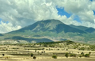
Iringa Region is one of Tanzania's 31 administrative regions. The region covers an area of 35,503 km2 (13,708 sq mi). The region is comparable in size to the combined land area of the nation state of Guinea Bissau. Iringa Region is bordered to the east by Morogoro Region and south by Njombe Region. On the west the region is bordered by Mbeya Region. Dodoma Region and Singida Region border Iringa on the north. The regional capital is the city Iringa for which the city is named after. According to the 2022 census, the region has a total population of 1,192,728. Iringa Region is home to Ruaha National Park, Tanzania's second national largest park.
Moshi is one of the seven administrative districts of the Kilimanjaro Region of Tanzania. The district covers an area of 1,300 km2 (500 sq mi). The District is bordered to the north by the Rombo District, to the west by the Hai District, to the east by the Mwanga District and Kenya, and to the south by Simanjiro District of Manyara Region. The district also surrounds Moshi Municipal District on three sides. According to the 2012 census, the population of the Moshi District was 466,737. By 2022, the population had grown to 535,803.

Iringa Rural District is one of the four districts of the Iringa Region of Tanzania, East Africa. It is bordered to the north by the Dodoma Region, to the east by Kilolo District and encircles Iringa Urban District, to the south by the Mufindi District, to the southwest by the Mbeya Region and to the northwest by the Singida Region.

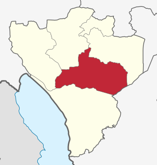
Kongwa District is one of the seven districts of the Dodoma Region of Tanzania. It is bordered to the north by Manyara Region, to the east by Morogoro Region, to the south by Mpwapwa District, and to the west by Chamwino District. Its district capital is the town of Kongwa.
As of 2021, there are 31 regions of Tanzania which are divided into 184 districts.

Geita District is located in the Geita Region of Tanzania. According to the 2022 census, the population of the district was 1,035,214. The district is bordered to the east by Mwanza Region and Nyang'hwale District, to the south by Shinyanga Region and Mbogwe District, and to the west by Chato District.
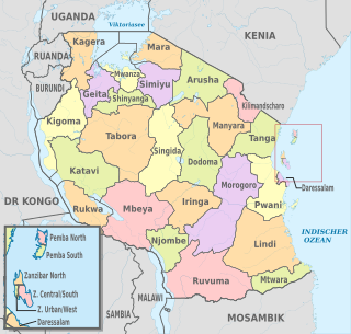
The administrative divisions of Tanzania are controlled by Part I, Article 2.2 of the Constitution of Tanzania. Tanzania is divided into thirty-one regions. Each region is subdivided into districts. The districts are sub-divided into divisions and further into local wards. Wards are further subdivided for management purposes: for urban wards into streets and for rural wards into villages. The villages may be further subdivided into hamlets.
Sumbwa is an Eastern Bantu language, classified as F.23 by Malcolm Guthrie (1948). According to this classification, the language is assumed to be related to Kinyamwezi, Kisukuma, Kinilamba, Kirimi and other languages of Zone F (Guthrie 1948; 1967-71, although Nurse and Philippson 1980 and Maselle suggested that the language has had much influence from neighbouring languages. Quick inspection of the vocabulary shows that Sisumbwa appears to be closer to Nyamwezi than to any other language in the group. In terms of contacts, Sisumbwa speakers say that for a long time they have been in contact with speakers of Kisubi, Kirongo and Kizinza and Kiha, in addition to Kinyamwezi and Kisukuma.

Geita Region is one of Tanzania's 31 administrative regions. The region covers an area of 20,054 km2 (7,743 sq mi)."Geita Region Size". The region is comparable in size to the combined land area of the nation state of Slovenia. Geita Region is bordered to the east by Lake Victoria, Mwanza Region and Shinyanga Region. The region is bordered by Tabora Region and Kigoma Region to the south and south west respectively. Lastly, Gieta is borders Kagera Region to the west.

Chato District is one of the five districts in Geita Region of northwestern Tanzania. Its administrative centre is the town of Chato. The main ethnic group in the district are the Sukuma. The late John Magufuli, who used to be as President of Tanzania from 2015—2021, was born in Chato.
Mpanda is a city in Katavi Region of Tanzania, East Africa with a postcode number 50100. It is the administrative centre of Katavi Region, Mpanda District and is itself one of the four districts of the region.

Njombe Rural District is one of the six districts of the Njombe Region of Tanzania, East Africa. Its administrative seat is Njombe town. The 2022 population was 182,127.
Njombe Urban District is one of the six districts of the Njombe Region of Tanzania, East Africa. The administrative seat for the district is in the city of Njombe.
Ushirombo is a town in the Geita Region in northwestern Tanzania. The town is the location of the district headquarters for Bukombe District. In 2016, its population was 95,052.

Kakonko District is one of the eight districts of the Kigoma Region of Tanzania. It is one of the 20 new districts that were formed in Tanzania since 2010; it was split off from Kibondo District. Kakonko District is bordered to the north by Kagera Region, to the east by Geita Region, to the south by Kibondo District, and to the west by Burundi. Its administrative seat is the town of Kakonko.

Bahi District is one of the seven districts of the Dodoma Region of Tanzania. Bahi District is bordered to the north by Chemba District, to the east by Dodoma District and Chamwino District, and to the west by Singida Region. Its administrative seat is the town of Bahi.
