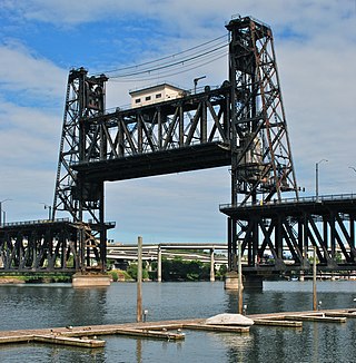
The Steel Bridge is a through truss, double-deck vertical-lift bridge across the Willamette River in Portland, Oregon, United States, opened in 1912. Its lower deck carries railroad and bicycle/pedestrian traffic, while the upper deck carries road traffic, and light rail (MAX), making the bridge one of the most multimodal in the world. It is the only double-deck bridge with independent lifts in the world and the second oldest vertical-lift bridge in North America, after the nearby Hawthorne Bridge. The bridge links the Rose Quarter and Lloyd District in the east to Old Town Chinatown neighborhood in the west.

The Hawthorne Bridge is a truss bridge with a vertical lift that spans the Willamette River in Portland, Oregon, joining Hawthorne Boulevard and Madison Street. It is the oldest vertical-lift bridge in operation in the United States and the oldest highway bridge in Portland. It is also the busiest bicycle bridge in Oregon, with over 8,000 cyclists and 800 TriMet buses daily. It was added to the National Register of Historic Places in November 2012.

The Coquille River is a stream, about 36 miles (58 km) long, in southwestern Oregon in the United States. It drains a mountainous area of 1,059 square miles (2,740 km2) of the Southern Oregon Coast Range into the Pacific Ocean. Its watershed is between that of the Coos River to the north and the Rogue River to the south.

The Fremont Bridge is a steel tied-arch bridge over the Willamette River located in Portland, Oregon, United States. It carries Interstate 405 and US 30 traffic between downtown and North Portland where it intersects with Interstate 5. It has the longest main span of any bridge in Oregon and is the second longest tied-arch bridge in the world. The bridge was designed by Parsons, Brinckerhoff, Quade and Douglas, and built by Murphy Pacific Corporation. In 2006, Sharon Wood Wortman published the third and latest version of The Portland Bridge Book. This book provides even more detail about the Fremont Bridge than covered here.

The Marquam Bridge is a double-deck, steel-truss cantilever bridge that carries Interstate 5 traffic across the Willamette River from south of downtown Portland, Oregon, on the west side to the industrial area of inner Southeast on the east. It is the busiest bridge in Oregon, carrying 140,500 vehicles a day as of 2016. The upper deck carries northbound traffic; the lower deck carries southbound traffic. The Marquam also has on and off ramps for Interstate 405 on the south end of the bridge, while the terminus on the east bank of the river is near the interchange with Interstate 84.

The Interstate Bridge is a pair of nearly identical steel vertical-lift, Parker through-truss bridges that carry Interstate 5 traffic over the Columbia River between Vancouver, Washington and Portland, Oregon in the United States.

The Sellwood Bridge is a deck arch bridge that spans the Willamette River in Portland, Oregon, in the United States. The current bridge opened in 2016 and replaced a 1925 span that had carried the same name. The original bridge was Portland's first fixed-span bridge and, being the only river crossing for miles in each direction, the busiest two-lane bridge in Oregon.

The BNSF Railway Bridge 5.1, also known as the St. Johns Railroad Bridge or the Willamette River Railroad Bridge, is a through truss railway bridge with a vertical lift that spans the Willamette River in Portland, Oregon, United States. Built by the Spokane, Portland and Seattle Railway (SP&S) and completed in 1908, it was originally a swing-span bridge, and its swing-span section was the longest in the world at the time. However, 81 years later the main span was converted from a swing-type to a vertical-lift type, in order to widen the navigation channel. The lift span is one of the highest and longest in the world. The bridge consists of five sections, with the two sections closest to the bank on each side fixed.

The George Abernethy Bridge, or simply Abernethy Bridge, is a steel plate and box girder bridge that spans the Willamette River between Oregon City and West Linn, Oregon, United States, and which carries Interstate 205. It is also known as the Oregon City Freeway Bridge and the I-205 Bridge.
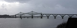
The Conde B. McCullough Memorial Bridge, is a cantilever bridge that spans the Coos Bay on U.S. Route 101 near North Bend, Oregon. When completed in 1936 it was named the North Bend Bridge. In 1947, it was renamed in honor of Conde B. McCullough who died on May 5, 1946. This and ten other major bridges on the Oregon Coast Highway were designed under his supervision.

U.S. Route 101 (US 101), is a major north–south U.S. Highway in Oregon that runs through the state along the western Oregon coastline near the Pacific Ocean. It runs from the California border, south of Brookings, to the Washington state line on the Columbia River, between Astoria, Oregon, and Megler, Washington.

Oregon Route 42 (OR 42) is an Oregon state highway which runs between U.S. Route 101 on the Oregon Coast, near Coos Bay, and Green, a few miles south of Roseburg on Interstate 5. OR 42 traverses the Coos Bay–Roseburg Highway No. 35 of the Oregon state highway system. The route splits at Coquille, where Oregon Route 42S heads southwest toward Bandon.
Historic ferries in Oregon are water transport ferries that operated in Oregon Country, Oregon Territory, and the state of Oregon, United States. These ferries allowed people to cross bodies of water, mainly rivers such as the Willamette in the Willamette Valley, and the Columbia, in order to transport goods, move people, and further communications until permanent bridges were built to allow faster crossing of the water. The early ferries were used by wagons and pedestrians, while later ones transported trains and then automobiles. Oregon has a few automobile ferries still in operation.

Boone Bridge is a steel girder highway bridge over the Willamette River at Wilsonville, Oregon, in the United States. Built in 1954, it crosses the river to the Charbonneau section of Wilsonville, carrying Interstate 5 into the open Willamette Valley from the Portland metropolitan area. Maintained by the Oregon Department of Transportation, the 1,111-foot-long (339 m) bridge has three travel lanes in each direction. To the west is the site of the former Boone's Ferry, which the bridge replaced.

The history of steamboats on the Oregon Coast begins in the late 19th century. Before the development of modern road and rail networks, transportation on the coast of Oregon was largely water-borne. This article focuses on inland steamboats and similar craft operating in, from south to north on the coast: Rogue River, Coquille River, Coos Bay, Umpqua River, Siuslaw Bay, Yaquina Bay, Siletz River, and Tillamook Bay. The boats were all very small, nothing like the big sternwheelers and propeller boats that ran on the Columbia River or Puget Sound. There were many of them, however, and they came to be known as the "mosquito fleet."

The Coquille River starts in the Siskiyou National Forest and flows through the Coquille Valley on its way to the Pacific Ocean. Bandon, Oregon, sits at the mouth of the Coquille River on the Pacific Ocean. Before the era of railroads and later, automobiles, the steamboats on the Coquille River were the major mode of transportation from Bandon to Coquille and Myrtle Point in southern Coos County, Oregon, United States.

Coquille was a steamboat built in 1908 for service on the Coquille River and its tributaries. Coquille served as a passenger vessel from 1908 to 1916, when the boat was transferred to the lower Columbia River. Coquille was reconstructed into a log boom towing boat, and served in this capacity from 1916 to 1935 or later.
Dispatch was a sternwheel steamboat that was operated on the Coquille River on the southern Oregon coast from 1903 to 1920. The name of this vessel is sometimes seen spelled Despatch. This sternwheeler should not be confused with an earlier and somewhat smaller sternwheeler, also named Dispatch, that was built at Bandon, Oregon, in 1890, for which the 1903 Dispatch was a replacement.

Wolverine was a launch powered by a gasoline engine that operated on the Coquille River on the southern coast of Oregon, United States, from 1908 to the 1920s. Later the boat operated on Coos Bay, and, in the mid-1930s, was transferred to Eureka, California. Wolverine is principally known for its early service as a high-speed passenger vessel.


