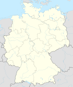
Location of the Bullenkuhle and geomorphological profile of the area
The Bullenkuhle is a predominantly marshy lake in the extreme north of the district of Gifhorn in the north German state of Lower Saxony. This strange biotope and geotope has been formed into a natural hollow in the terrain that is termed a sinkhole. The area is environmentally protected.
Lower Saxony is a German state (Land) situated in northwestern Germany. It is the second-largest state by land area, with 47,624 km2 (18,388 sq mi), and fourth-largest in population among the 16 Länder federated as the Federal Republic of Germany. In rural areas, Northern Low Saxon and Saterland Frisian are still spoken, but the number of speakers is declining.
A biotope is an area of uniform environmental conditions providing a living place for a specific assemblage of plants and animals. Biotope is almost synonymous with the term habitat, which is more commonly used in English-speaking countries. However, in some countries these two terms are distinguished: the subject of a habitat is a population, the subject of a biotope is a biocoenosis or biological community.
Geotope is the geological component of the abiotic matrix present in an ecotope. Example geotopes might be: an exposed outcrop of rocks, an erratic boulder, a grotto or ravine, a cave, an old stone wall marking a property boundary, and so forth.
The Bullenkuhle lies about 15 kilometres south of the town of Uelzen and a good kilometre west of the village of Bokel (in the municipality of Sprakensehl) at the edge of a large pine forest at a height of about 95 metres (312ft) above NN. A stream emerges in the immediate vicinity which is initially called the Bokeler Bach and, later, becomes the Aue and finally, after combining with other streams, becomes an Elbe tributary, the River Ilmenau. The area belongs to the southeast fringes of the Hohen Heide in the centre of the Lüneburg Heath. This landscape formed from end and ground moraines and periglacial sediments was created geomorphologically mainly by the edges of the ice sheet during the later phases of the Saalian glaciation, i.e. during the so-called Drenthe II stage and the final glacial advance of the Warthe stage. The crests of the undulating ridges of end moraines are usually covered with pine forests growing on sandy soils; the ground moraines were used for agriculture. The typical open heath landscape of the Lüneburg Heath - which arose anthropogenically through overexploitation of forests, burning, plaggen cutting and grazing - only exists today in fragments in the area around the Bullenkuhle. The macroclimate of the Lüneburg Heath is maritime temperate.
Uelzen is a town in northeast Lower Saxony, Germany, and capital of the county of Uelzen. It is part of the Hamburg Metropolitan Region, a Hanseatic town and an independent municipality.
Sprakensehl is a municipality in the district of Gifhorn, in Lower Saxony, Germany. Sprakensehl includes the villages of Behren, Blickwedel, Bokel, Hagen, Masel, Sprakensehl and Zittel.
The Elbe is one of the major rivers of Central Europe. It rises in the Krkonoše Mountains of the northern Czech Republic before traversing much of Bohemia, then Germany and flowing into the North Sea at Cuxhaven, 110 km (68 mi) northwest of Hamburg. Its total length is 1,094 kilometres (680 mi).
Formation of the sinkhole
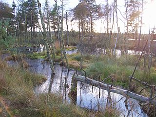
The Bullenkuhle in early spring. A bog pond can be seen in the background
In north Germany there are numerous salt domes under the ground – relicts of the Zechstein Sea from the Permian period, which were later relocated and deformed tectonically. When rock salt comes into contact with ground water it leaches away; i.e. the salt is absorbed by the water and transported off. This can lead to the development of large caverns that finally cave in. Sometimes such an event at a depth of several hundred metres can result in the ground collapsing right up to the surface. This results in prominent, often steep-sided and deep hollows called sinkholes or dolines (although dolines can have other morphogenetic causes, particularly in karst regions). Many of these funnel-shaped hollows remain dry, in others water collects that can later become marshy. Sinkholes are geologically often very recent; it is not uncommon for them to be only a few thousand years old and many hollows only date back a few hundred years.
The Permian is a geologic period and system which spans 47 million years from the end of the Carboniferous period 298.9 million years ago (Mya), to the beginning of the Triassic period 251.902 Mya. It is the last period of the Paleozoic era; the following Triassic period belongs to the Mesozoic era. The concept of the Permian was introduced in 1841 by geologist Sir Roderick Murchison, who named it after the region of Perm in Russia.
Karst is a topography formed from the dissolution of soluble rocks such as limestone, dolomite, and gypsum. It is characterized by underground drainage systems with sinkholes and caves. It has also been documented for more weathering-resistant rocks, such as quartzite, given the right conditions. Subterranean drainage may limit surface water, with few to no rivers or lakes. However, in regions where the dissolved bedrock is covered or confined by one or more superimposed non-soluble rock strata, distinctive karst features may occur only at subsurface levels and can be totally missing above ground.
The Lake Arend is a natural lake in the Altmark region, northern Saxony-Anhalt, Germany. It is 23.3 m above sea level, and its area is 5.14 km², its depth nearly 50 m. It is the largest and deepest natural lake in Saxony-Anhalt.
Zwischenahner Meer (help·info) is a lake in Ammerland, Lower Saxony, Germany. It is at an elevation of approximately 5 meters, and has a surface area of 5.5 km². The town of Bad Zwischenahn is located on the southern end of the lake, Rostrup on the western end, and Dreibergen on the northern end. It is the third largest lake in Lower Saxony.
Seeburger See is a lake in the karst region of the Lower Eichsfeld, Landkreis Göttingen, in southeastern Lower Saxony, Germany.
Description
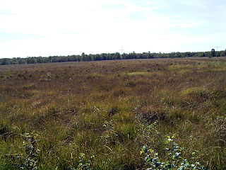
The visitor to the Bullenkuhle comes across a basin-shaped hollow with steep sides of 30 to 60° in places. At the foot of the slopes of glacial sands is a marsh covering about 0.5 hectares (1.2 acres) that on closer inspection turns out to be a 'quaking bog' (Schwingrasen or Schwingmoor) - a floating mat of moss and other plants, under which there is presumably no homogeneous layer of peat, but at least in places just a body of water. The floating mat covers at least 80% of the wetland or marsh, only in the northeast is there stretch of open water about 0.1 hectares (0.25 acres) in area and several metres deep; a so-called bog pond. With an electrolytic conductivity of 24 μS/cm this wetland is very oligotrophic, it is rich in humus and, with a pH value of 5.0, moderately acidic. It is populated by typical marsh plants like peat mosses, bladderworts and the rare Dwarf White Water Lily (Nymphaea candida). In addition to peat mosses, the floating mat pressing in on the bog pond consists mainly of Hare's-tail Cottongrass, Cross-leaved Heath, Common Heather and Crowberry; as well as White Beak-sedge and Cranberry. The largely unwooded terrain can be described as flat to slightly rounded intermediate marsh (Zwischenmoor). On its periphery is a ring-shaped bog, which is slightly better supplied with nutrients from precipitation running down the slopes than the centre of the marsh. Bottle Sedge reeds thrive particularly well here.
A bog pond is a waterbody in the middle of a raised or kettle bog, formerly also in percolating mires (Durchströmungsmooren). It is also called a bog eye, raised bog kolk, bog kolk or just kolk.
Conductivity of an electrolyte solution is a measure of its ability to conduct electricity. The SI unit of conductivity is Siemens per meter (S/m).
Sphagnum is a genus of approximately 380 accepted species of mosses, commonly known as "peat moss". Accumulations of Sphagnum can store water, since both living and dead plants can hold large quantities of water inside their cells; plants may hold 16 to 26 times as much water as their dry weight, depending on the species. The empty cells help retain water in drier conditions.
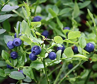
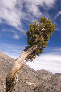
The slopes of the funnel-shaped terrain are covered with low vegetation such as Common Heather, Bilberry, and Cranberry, and also with Purple Moor Grass and trees. The latter include several very large and old Juniper bushes and trees, especially conspicuous and typical of the terrain. Other varieties include birch trees, Buckthorn bushes and pines. The animal world is also noteworthy and some species are peculiar to marsh biotopes. In particular there are up to eight species of amphibian as well as adders.
Bilberries, or occasionally European blueberries, are a primarily Eurasian species of low-growing shrubs in the genus Vaccinium, bearing edible, dark blue berries. The species most often referred to is Vaccinium myrtillus L., but there are several other closely related species.
Cranberries are a group of evergreen dwarf shrubs or trailing vines in the subgenus Oxycoccus of the genus Vaccinium. In Britain, cranberry may refer to the native species Vaccinium oxycoccos, while in North America, cranberry may refer to Vaccinium macrocarpon. Vaccinium oxycoccos is cultivated in central and northern Europe, while Vaccinium macrocarpon is cultivated throughout the northern United States, Canada and Chile. In some methods of classification, Oxycoccus is regarded as a genus in its own right. They can be found in acidic bogs throughout the cooler regions of the Northern Hemisphere.
Junipers are coniferous trees and shrubs in the genus Juniperus of the cypress family Cupressaceae. Depending on taxonomic viewpoint, between 50 and 67 species of junipers are widely distributed throughout the Northern Hemisphere, from the Arctic, south to tropical Africa, from Ziarat, Pakistan, east to eastern Tibet in the Old World, and in the mountains of Central America. The highest-known juniper forest occurs at an altitude of 16,000 ft (4,900 m) in southeastern Tibet and the northern Himalayas, creating one of the highest tree-lines on earth.
Literature
J. Delfs: Die Bullenkuhle. In: Naturschutzgebiete im Raum Gifhorn-Wolfsburg. 1986
R. Pott: Lüneburger Heide. Exkursionsführer Kulturlandschaften, Ulmer-Verlag, Stuttgart 1999, ISBN3-8001-3515-9
R. Tüxen: Die Bullenkuhle bei Bokel. Abhandl. naturwiss. Ver., Bremen 1958, 35/2: 374-394
Ernst Andreas Friedrich: Naturdenkmale Niedersachsens. Hannover, 1980. ISBN3-7842-0227-6
Eberhard Rohde: Die Sage von der Bullenkuhle in: Sagen und Märchen aus dem Raum Gifhorn-Wolfsburg, Gifhorn, 1994 ASINB005IC0SAW
Askham Bog is small area of peat bog and Site of Special Scientific Interest situated within the Vale of York in North Yorkshire, England. It lies to the south-west of York, north of Copmanthorpe and near Askham Richard and Askham Bryan.
Lüneburg Heath is a large area of heath, geest, and woodland in the northeastern part of the state of Lower Saxony in northern Germany. It forms part of the hinterland for the cities of Hamburg, Hanover and Bremen and is named after the town of Lüneburg. Most of the area is a nature reserve. Northern Low Saxon is still widely spoken in the region.
Pinhook Bog is a unique bog in Indiana that has been designated a National Natural Landmark. It is part of Indiana Dunes National Park, an area that many citizens, scientists, and politicians fought hard to preserve. Its sister bog, Volo Bog, is located nearby. The bog contains a large variety of plants, including insect eating plants, tamarack trees, stands of blueberry bushes, and floating mats of sphagnum moss. Pinhook Bog is about 580 acres (2.3 km2), a quarter of which is a floating mat of sphagnum peat moss. A "moat" separates the bog from the uplands.
The peat therapy resortMoorbad Gmös in the vicinity of the town of Laakirchen is one of the few bogs in the Alpine foothills of Upper Austria. The bog dates back to the Mindel glaciation and was created by a "dead-ice hole". In 1987 the local authorities of Upper Austria declared the area of 3.4 ha of the Gmöser Moor a natural preserve. A path around the area has since then given the visitor the opportunity of observing rare flora and fauna. In 2002 the spa was chosen as background scenery for the TV-production Schlosshotel Orth.
Cors Caron is a raised bog in Ceredigion, Wales. Cors is the Welsh word for "bog": the site is also known as Tregaron Bog, being near the small town of Tregaron. Cors Caron covers an area of approximately 862 acres (349 ha). Cors Caron represents the most intact surviving example of a raised bog landscape in the United Kingdom. About 44 different species groups inhabit the area including various land and aquatic plants, fish, insects, crustaceans, lichen, fungi, terrestrial mammals and birds.
The North German Plain or Northern Lowland is one of the major geographical regions of Germany. It is the German part of the North European Plain. The region is bounded by the coasts of the North Sea and the Baltic Sea to the north and Germany's Central Uplands to the south.
Raised bogs, also called ombrotrophic bogs, are acidic, wet habitats that are poor in mineral salts and are home to flora and fauna that can cope with such extreme conditions. Raised bogs, unlike fens, are exclusively fed by precipitation (ombrotrophy) and from mineral salts introduced from the air. They thus represent a special type of bog, hydrologically, ecologically and in terms of their development history, in which the growth of peat mosses over centuries or millennia plays a decisive role. They also differ in character from blanket bogs which are much thinner and occur in wetter, cloudier climatic zones.
The Südheide Nature Park is a large protected area of forest and heathland in the southern part of the Lüneburg Heath in North Germany. It has been designated as a protected nature park since 1964.
The Grundloses Moor is the largest, virtually intact raised bog in the district of Heidekreis and a nature reserve in Walsrode in the German state of Lower Saxony.
The Tiste Bauernmoor is an area of raised bog on the Lüneburg Heath in north Germany that was designated as a nature reserve on 2 May 2002. It has an area of 570 hectares and belongs, together with the Ekelmoor, Avensermoor and Everstofer Moor, to the large Ekelmoor moorland region that has a total area of 1,220 hectares.
The Großes Moor near Gifhorn is part of the Northwest German raised bog region, which stretches from the Netherlands to the eastern border of Lower Saxony on the sandy areas (geest) left behind by the ice age. The moor has a total area of about 6,100 hectares, of which around 5,000 hectares are raised bog and some 1,100 hectares are fen. The peat layer is up to almost 6 metres thick in places. Individual parts of the moor have their own names like Stüder Moor, Hestenmoor or Weißes Moor.
The Maujahn or Maujahn Moor is a kettle bog in North Germany which began as a sinkhole. It is located a good two kilometres west of the town of Dannenberg between the villages of Thunpadel and Schmarsau in northeastern Lower Saxony.
The Hanoverian Moor Geest is a gently rolling landscape between Hanover and Nienburg in the German state of Lower Saxony covering an area of around 800 square kilometres (310 sq mi). It belongs to the raised bog regions of northwest Germany, which cover the geest terrain formed during the ice age and which stretch from the Netherlands to the eastern border of Lower Saxony. The geest tract on the Hanoverian Moor Geest consists of a ground moraine plateau with a height of 50–85 m above sea level that is dominated by bog. Its natural boundaries are the Aller glacial valley to the north and the Burgdorf-Peine Geest to the east.
The Georgenfelder Hochmoor is a raised bog (Hochmoor) in the German Ore Mountains of central Europe, not far from Zinnwald-Georgenfeld. It is part of a larger bog or moor complex, that lies to the south, mainly on the far side of the Germany's national border in the Czech Republic and which, since time immemorial, has been known simply as "The Lake". The Georgenfelder Hochmoor is one of the oldest nature reserves in Saxony.
Barelees Pond is the name given to a Site of Special Scientific Interest (SSSI) in north Northumberland, England. The site is a kettle hole, a deep pond formed in the void remaining after a submerged glacial calf block melted. Barelees Pond is illustrative of vegetative habitat evolution as peat sediment gradually fills the pond.
Bewick and Beanley Moors is the name given to a Site of Special Scientific Interest (SSSI) in north Northumberland, in the north-east of England. The moors are asserted to be of national importance by Natural England for the extent, quality and diversity of upland types including heaths, fens, wet grassland, flushes, mires and blanket bogs, together creating an extensive mosaic habitat supporting an exceptional community of amphibians. The moors are important, too, for their relict juniper woodland and scrub.
A floating mat is a layer of mosses and other, especially stoloniferous, plants that grows out from the shore across the surface of a lake or pond. This type of habitat is protected and is designated in the European Habitats Directive as "LRT No. 7140 Transition and Floating Mat Bogs".
This page is based on this Wikipedia article Text is available under the CC BY-SA 4.0 license; additional terms may apply. Images, videos and audio are available under their respective licenses.