Bullfrog Basin Airport

Last updated
Bullfrog Basin Airport
Summary
Airport type Public
Owner U.S. National Park Service
Serves Glen Canyon National Recreation Area, Utah
Elevation  AMSL 4,167 ft / 1,270 m
Coordinates 37°32′45″N110°42′48″W / 37.54583°N 110.71333°W / 37.54583; -110.71333
Runways
Direction Length Surface
ft m
1/19 3,500 1,067 Asphalt
Statistics (2006)
Aircraft operations 451

Bullfrog Basin Airport( IATA : BFG, FAA LID : U07) is a public airport located 5 miles (8 km) north of the central business district of the Glen Canyon National Recreation Area, in Kane County, Utah, United States. It is owned by the U.S. National Park Service. [1]

An IATA airport code, also known as an IATA location identifier, IATA station code or simply a location identifier, is a three-letter code designating many airports around the world, defined by the International Air Transport Association (IATA). The characters prominently displayed on baggage tags attached at airport check-in desks are an example of a way these codes are used.

Federal Aviation Administration United States Government agency dedicated to civil aviation matters

The Federal Aviation Administration (FAA) is a governmental body of the United States with powers to regulate all aspects of civil aviation in that nation as well as over its surrounding international waters. Its powers include the construction and operation of airports, air traffic management, the certification of personnel and aircraft, and the protection of U.S. assets during the launch or re-entry of commercial space vehicles. Powers over neighboring international waters were delegated to the FAA by authority of the International Civil Aviation Organization.

A location identifier is a symbolic representation for the name and the location of an airport, navigation aid, or weather station, and is used for manned air traffic control facilities in air traffic control, telecommunications, computer programming, weather reports, and related services.

Contents

The airport is located 5 miles (8 km) north of Bullfrog Marina and Lake Powell. There are no aircraft assigned or stationed here; it is for transient aircraft and visitors to Lake Powell and Glen Canyon National Recreation Area.

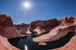
Bullfrog Marina is the second largest marina on Lake Powell. It is located 70 miles (110 km) from Hanksville, Utah and 95 lake miles from Glen Canyon Dam. It is also located across from Hall's Crossing Marina. Lake Powell, and all of its points of interest, is managed by the National Park Service and available to the public for recreational purposes.

Lake Powell reservoir in the United States

Lake Powell is a reservoir on the Colorado River, straddling the border between Utah and Arizona, United States. Most of Lake Powell, along with Rainbow Bridge National Monument, is located in Utah. It is a major vacation spot that around two million people visit every year. It is the second largest man-made reservoir by maximum water capacity in the United States behind Lake Mead, storing 24,322,000 acre feet (3.0001×10¹⁰ m3) of water when full. However, due to high water withdrawals for human and agricultural consumption, and because of subsequent droughts in the area, Lake Mead has fallen below Lake Powell in size several times during the 21st century in terms of volume of water, depth and surface area.

Facilities and aircraft

Bullfrog Basin Airport covers an area of 42 acres (17 ha) and contains one runway designated 1/19 with a 3,500 x 40 ft (1,067 x 12 m) asphalt surface. For the 12-month period ending December 31, 2006, the airport had 451 aircraft operations: 78% general aviation and 22% air taxi. [1]

Runway Area of surface used by aircraft to takeoff from and land on

According to the International Civil Aviation Organization (ICAO), a runway is a "defined rectangular area on a land aerodrome prepared for the landing and takeoff of aircraft". Runways may be a man-made surface or a natural surface.

Asphalt sticky, black and highly viscous liquid or semi-solid form of petroleum; bitumen variety

Asphalt, also known as bitumen, is a sticky, black, and highly viscous liquid or semi-solid form of petroleum. It may be found in natural deposits or may be a refined product, and is classed as a pitch. Before the 20th century, the term asphaltum was also used. The word is derived from the Ancient Greek ἄσφαλτος ásphaltos.

General aviation civil use of aircraft excluding commercial transportation

General Aviation (GA) is the name or term given to all civil aviation aircraft operations with the exception of commercial air transport (CAT) or aerial work (AW); that is, flight activities not involving commercial air transportation of passengers, cargo or mail for remuneration or hire, or an aerial work operation such as agriculture, construction, photography, surveying, observation and patrol, search and rescue, aerial advertisement, etc. It covers certain commercial and private flights that can be carried out under both visual flight (VFR) and instrument flight (IFR) rules, such as light aircraft, business and private jets or helicopters. General aviation thus represents the 'private transport' component of aviation.

Related Research Articles

Glen Canyon National Recreation Area recreation area in Utah and Arizona in the United States

Glen Canyon National Recreation Area is a recreation and conservation unit of the National Park Service (USA) that encompasses the area around Lake Powell and lower Cataract Canyon in Utah and Arizona, covering 1,254,429 acres (5,076 km2) of mostly desert. The recreation area borders Capitol Reef National Park and Canyonlands National Park on the north, Grand Staircase-Escalante National Monument on the west, Vermilion Cliffs National Monument and the northeasternmost reaches of Grand Canyon National Park on the southwest, and the Navajo Nation on the southeast.

Utah State Route 276 highway in Utah

State Route 276 is a state highway in remote portions of San Juan County, eastern Garfield County, and Kane County, in the southeast of the U.S. state of Utah. The route is used as an access to Lake Powell, serving the small resort towns of Ticaboo and Bullfrog. SR-276 crosses Lake Powell via the Charles Hall Ferry, the only auto ferry in the state of Utah. The entire route is part of the Trail of the Ancients National Scenic Byway. Lake Powell separates the route into two sections; the eastern section was numbered State Route 263 prior to the existence of the ferry.

Lake Hood Seaplane Base

Lake Hood Seaplane Base is a state-owned seaplane base located three nautical miles (6 km) southwest of the central business district of Anchorage in the U.S. state of Alaska. The Lake Hood Strip is a gravel runway located adjacent to the seaplane base. The gravel strip airport's previous code of has been decommissioned and combined with as another landing surface.

Summit Airport (Delaware)

Summit Airport is a public-use airport located 5 miles (8.0 km) north of the central business district of Middletown, in New Castle County, Delaware, United States. It is privately owned by Summit Aviation, Inc. It is included in the Federal Aviation Administration (FAA) National Plan of Integrated Airport Systems for 2017–2021, in which it is categorized as a reliever general aviation facility.

Temple Bar Airport airport

Temple Bar Airport is a public use airport in Mohave County, Arizona, United States. It is 1.15 miles southwest of the Temple Bar Marina, located on Lake Mead's Temple Basin. The airport is owned by the U.S. National Park Service.

Echo Bay Airport

Echo Bay Airport is a public use airport owned by and located in the Lake Mead National Recreation Area. It is 14 nautical miles (26 km) south of the central business district of Overton, a town in Clark County, Nevada, United States. The airport is situated near Echo Bay on Lake Mead.

First Flight Airport public use airport near Kill Devil Hills, North Carolina, USA

First Flight Airport is a public use airport located one nautical mile (2 km) west of the central business district of Kill Devil Hills, a town in Dare County, North Carolina, United States. The airport is owned by the U.S. National Park Service. It is included in the National Plan of Integrated Airport Systems for 2011–2015, which categorized it as a general aviation facility.

Joseph State Airport airport

Joseph State Airport is a public use airport located one nautical mile west of the central business district of Joseph, a city in Wallowa County, Oregon, United States. It is owned by the Oregon Department of Aviation.

Bryce Canyon Airport

Bryce Canyon Airport is a public airport located four miles (6 km) north of Bryce Canyon, in Garfield County, Utah, United States. It is owned by Garfield County.

Bullfrog, Utah Unincorporated community in Utah, United States

Bullfrog, or Bullfrog Basin Marina, is a small unincorporated community on the shores of Lake Powell's Bullfrog Bay in the Glen Canyon National Recreation Area of Kane County, Utah, United States. Bullfrog is a popular place on Lake Powell for tourists, fishermen, and outdoor enthusiasts due to its marina and local resources. It is the northern terminus for the Charles Hall Ferry, an automobile ferry that connects across Lake Powell to Halls Crossing in San Juan County. Bullfrog was named after a rock formation on the western side of Mt Ellsworth that you can see from Utah State Route 276, heading south.

Baudette International Airport

Baudette International Airport is a county-owned public-use airport located one mile (2 km) north of the central business district of Baudette, a city in Lake of the Woods County, Minnesota, United States. Also known as Baudette International Airport & Seaplane Base, it is located on the Rainy River, which is the border between Minnesota in the U.S. and Ontario in Canada.

Maple Lake Municipal Airport airport

Maple Lake Municipal Airport is a city-owned, public-use airport located one nautical mile (2 km) northeast of the central business district of Maple Lake, a city in Wright County, Minnesota, United States. It is located on Maple Lake and is also known as Maple Lake Municipal Airport & Seaplane Base.

Big Lake Airport airport

Big Lake Airport is a state-owned public-use airport located one nautical mile (1.8 km) southeast of the central business district of Big Lake, in the Matanuska-Susitna Borough of the U.S. state of Alaska.

Lake Wales Municipal Airport

Lake Wales Municipal Airport is a public-use airport located 2 miles (3.2 km) west of the central business district of the city of Lake Wales in Polk County, Florida, United States. The airport is publicly owned.

Burnett County Airport

Burnett County Airport is a county-owned public use airport located three nautical miles (6 km) north of the central business district of Siren, in Burnett County, Wisconsin, United States. It is included in the Federal Aviation Administration (FAA) National Plan of Integrated Airport Systems for 2019–2023, in which it is categorized as a local general aviation facility.

Harry Stern Airport is a public use airport in Richland County, North Dakota, United States. It is located one nautical mile (1.85 km) south of the central business district of Wahpeton, North Dakota and owned by the Wahpeton Airport Authority.

Pearce Ferry Airport airport

Pearce Ferry Airport is a public use airport in Mohave County, Arizona, United States. The airport is owned by the National Park Service. It is located 3.5 miles north of the central business district of Meadview and 2.9 miles east of Lake Mead's Gregg Basin.

Polson Airport

Polson Airport is a public use airport in Lake County, Montana, United States. It is located one nautical mile (2 km) west of the central business district of Polson, a city on the southern shore of Flathead Lake. The airport is owned by the City of Polson and Lake County. It is included in the National Plan of Integrated Airport Systems for 2011–2015, which categorized it as a general aviation facility.

References