Aberdeenshire is one of the 32 council areas of Scotland.

The Battle of Mons Graupius was, according to Tacitus, a Roman military victory in what is now Scotland, taking place in AD 83 or, less probably, 84. The exact location of the battle is a matter of debate. Historians have long questioned some details of Tacitus's account of the fight, suggesting that he exaggerated Roman success.
Braemar is a village in Aberdeenshire, Scotland, around 58 miles (93 km) west of Aberdeen in the Highlands. It is the closest significantly-sized settlement to the upper course of the River Dee, sitting at an elevation of 339 metres (1,112 ft).

Cadbury Castle is a Bronze and Iron Age hillfort in the civil parish of South Cadbury in the English county of Somerset. It is a scheduled monument and has been associated with King Arthur's legendary court at Camelot.

Dolebury Warren is a 90.6 hectares biological Site of Special Scientific Interest (SSSI) and ancient monument near the villages of Churchill and Rowberrow in North Somerset, part of South West England. It is owned by the National Trust, who acquired the freehold in 1983, and managed by the Avon Wildlife Trust.

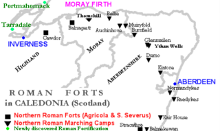
Raedykes is the site of a Roman marching camp located just over three miles northwest of Stonehaven, Aberdeenshire, Scotland. National Grid Reference NO 842902. It is designated as a scheduled monument. A marching camp was a temporary camp used mainly for overnight stops on a long route between more permanent forts, or as a temporary base while on campaign in hostile territory.

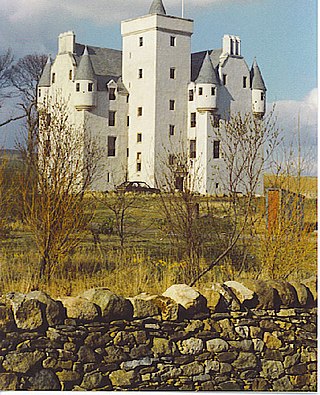
Leslie Castle is a castle in Aberdeenshire, Scotland, the historical seat of Clan Leslie, located just to the west of Auchleven, or about 45 kilometres (28 mi) northwest of Aberdeen.

Ythan Wells, also known as Glenmailen, is the site of a Roman military camp, near the farm of Glenmellan, 2.1 kilometres (1.3 mi) east of the village of Ythanwells in Aberdeenshire, Scotland. The site is a designated scheduled monument.
Deers Den is an archaeological site at Kintore, Scotland in Aberdeenshire. The site has mesolithic remains, Iron Age artefacts and is a known Roman Camp.

The Tap o' Noth is a hill and fort, 8 miles south of Huntly in Aberdeenshire, Scotland at grid reference NJ485293. It is the second highest fort in Scotland and its main feature is its well-preserved vitrified wall which encloses an area of approximately 100 m by 30 m, 0.3 hectares. Archaeological finds from the site include a stone axe head dated to between c. 2000 BC– c.800 BC, and a decorated bronze rein-ring dated to the 1st–3rd century AD. The site has been designated a scheduled ancient monument.

Muiryfold was one of the Roman fortifications built by Septimius Severus in northern Caledonia. The site is located 6 kilometres (3.7 mi) east of Keith in Moray.
Hillforts in Britain refers to the various hillforts within the island of Great Britain. Although the earliest such constructs fitting this description come from the Neolithic British Isles, with a few also dating to later Bronze Age Britain, British hillforts were primarily constructed during the British Iron Age. Some of these were apparently abandoned in the southern areas that were a part of Roman Britain, although at the same time, those areas of northern Britain that remained free from Roman occupation saw an increase in their construction. Some hillforts were reused in the Early Middle Ages, and in some rarer cases, into the Later Medieval period as well. By the early modern period, these had essentially all been abandoned, with many being excavated by archaeologists in the nineteenth century onward.
Thomshill, located 6 kilometres (3.7 mi) south of Elgin in Moray, Scotland, is the site of an excavated rectilinear enclosure that has been interpreted as a possible Roman military camp or fort. The enclosure covers an area of approximately 3.25 hectares and is situated at a height of 72 metres (236 ft) above ordnance datum.
Balnageith, located on the western edge of the suburbs of Forres in Moray, Scotland, is the site of an excavated linear cropmark with a rounded corner that has been interpreted as a possible Roman military camp or fort. The enclosure may originally have been of up to 2.4 hectares in size.
Durno or Logie Durno, located 6 miles (9.7 km) north west of Inverurie in Aberdeenshire, Scotland, is the site of a Roman marching camp, first discovered by aerial photography in July 1975 and excavated in 1976 and 1977.
Auchinhove, located to the east of Keith in Moray, Scotland, is the site of a Roman marching camp, first discovered by aerial photography in 1949.
Bellie is a locality in Moray, Scotland. Little survives of the old parish church at Bellie, located 2 miles north of Fochabers, although its graveyard is preserved. There is a Bellie Kirk in Fochabers, which replaced the old church in 1798.

The Bulwarks, Porthkerry is a promontory fort in Rhoose, Vale of Glamorgan, on the southern coast of Wales overlooking the Bristol Channel. It probably dates to the Iron Age and continued to be occupied during the Roman period in Britain. The ramparts and ditches along the west side are well preserved, but the fortifications are heavily overgrown.

Dunnideer stone circle is a mostly destroyed recumbent stone circle located near Insch in Aberdeenshire, Scotland. The three remaining stones lie close to the ruins of Dunnideer Castle. It is a scheduled monument.


