
Burreth (also occasionally Burgrede) [1] is a now-deserted village in Lincolnshire.
Burreth (also occasionally Burgrede) [1] is a now-deserted village in Lincolnshire.
In the late 13th century, the manor of Burreth was held by Robert de Neville, who held it two-thirds from the Earl of Lincoln and one-third from the Bishop of Lincoln. [2] For the purposes of the 1377 poll tax, the village possessed 74 taxable individuals, and it paid £1 4s 8d. [3] Burreth, in what is now the district of East Lindsey in Lincolnshire, was recorded in the Domesday Book and last recorded as extant in 1381. Although the village itself is extinct, its eponymous parish is conterminous with Tupholme. Burreth had a village church dedicated to St Peter [4] and was under the auspices of Tupholme Abbey; the last recorded priest died in 1349 during the Black Death. [5] [note 1]

Earthworks and crop marks are visible from aerial photography, as well as a moat, a mound that local legend has as the site of the church, and what Historic England describes as "a confused area to the southeast, probably house steadings but mutilated by surface quarrying". Original stone, pottery and tile of the buildings have been found, including the possible outline of the church, 16 metres (52 ft) by 9 metres (30 ft) [5] Burreth was home to at least one hermit in the 13th century. [7]
The most recent archaeological survey to have been carried out was in 1964, although since then much further ploughing has reduced the searchable area of the village.

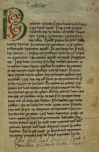
Domesday Book – the Middle English spelling of "Doomsday Book" – is a manuscript record of the "Great Survey" of much of England and parts of Wales completed in 1086 at the behest of King William I, known as William the Conqueror. The manuscript was originally known by the Latin name Liber de Wintonia, meaning "Book of Winchester", where it was originally kept in the royal treasury. The Anglo-Saxon Chronicle states that in 1085 the king sent his agents to survey every shire in England, to list his holdings and dues owed to him.

The Peasants' Revolt, also named Wat Tyler's Rebellion or the Great Rising, was a major uprising across large parts of England in 1381. The revolt had various causes, including the socio-economic and political tensions generated by the Black Death in the 1340s, the high taxes resulting from the conflict with France during the Hundred Years' War, and instability within the local leadership of London.

Caistor is a town and civil parish in the West Lindsey district of Lincolnshire, England. As its name implies, it was originally a Roman castrum or fortress. It lies at the north-west edge of the Lincolnshire Wolds, on the Viking Way, and just off the A46 between Lincoln and Grimsby, at the A46, A1084, A1173 and B1225 junction. It has a population of 2,601. Its name comes from the Anglo-Saxon ceaster and was given in the Domesday Book as Castre.

Beer Hackett is a small village and civil parish in west Dorset, England, situated 3 miles (4.8 km) southwest of Sherborne and 5 miles (8.0 km) southeast of Yeovil. The civil parish includes the small settlement of Knighton to the east. Dorset County Council's 2013 mid-year estimate of the population of the civil parish is 100.

Chetnole is a village and civil parish in the county of Dorset in southern England. It lies approximately 6 miles (9.7 km) south-southwest of Sherborne and 5.5 miles (8.9 km) southeast of Yeovil in Somerset. It is sited on Oxford clay by the small Wriggle River at the western end of the Blackmore Vale. There are around 128 houses in the village. It has a railway station on the Heart of Wessex Line that is served by Great Western Railway services. Dorset County Council estimate that in 2013 the population of the parish was 330. In the 2011 census the population of Chetnole parish combined with the small parish of Stockwood to the west was 344.

Bardney is a village and civil parish in the West Lindsey district of Lincolnshire, England. The population of the civil parish was 1,643 at the 2001 census increasing to 1,848 at the 2011 census. The village sits on the east bank of the River Witham and 9 miles (14 km) east of the city and county town of Lincoln.

Tupholme is a village in the East Lindsey district of Lincolnshire, England. It is situated 11 miles (18 km) east from Lincoln, and is the site of the ruined Tupholme Abbey on the road between Horncastle and Bardney. The population is included in the civil parish of Bucknall.
The hide was an English unit of land measurement originally intended to represent the amount of land sufficient to support a household. It was traditionally taken to be 120 acres , but was in fact a measure of value and tax assessment, including obligations for food-rent, maintenance and repair of bridges and fortifications, manpower for the army, and (eventually) the geld land tax. The hide's method of calculation is now obscure: different properties with the same hidage could vary greatly in extent even in the same county. Following the Norman Conquest of England, the hidage assessments were recorded in the Domesday Book of 1086, and there was a tendency for land producing £1 of income per year to be assessed at 1 hide. The Norman kings continued to use the unit for their tax assessments until the end of the 12th century.
Pattesley is a village in the English county of Norfolk, about one mile (1.6 km) south of the village of Oxwick. It consists of a few scattered houses. The population is included in the civil parish of Colkirk.

Aylesby is a village and civil parish in North East Lincolnshire, England. It is situated near the A18 road, approximately 4 miles (6 km) west from Cleethorpes and north of Laceby. The population at the 2001 census was 135, increasing to 155 at the 2011 Census.

Barlings Abbey, Lincolnshire, was a Premonstratensian monastery in England, founded in 1154, as a daughter house of the Abbey of St. Mary and St. Martial in Newsham.

Tupholme Abbey was a Premonstratensian abbey close to the River Witham some 10+1⁄2 miles (16.9 km) east of the city of Lincoln, England. The Witham valley in Lincolnshire is notable for its high concentration of monasteries—there were six on the east bank and three on the west—all presumably drawn to the area by the usefulness of the River Witham for transport and by the wealth that it transported. The abbey was largely destroyed by 1538, after being seized during Henry VIII's Dissolution of the Monasteries.

Great Wratting is a village and civil parish in England, about four miles from Haverhill, Suffolk, in the valley of the River Stour. There is a ford across the Stour in the centre of the village, where bathing and fishing are common pursuits. The river here is heavily populated by crayfish, a non native species long since escaped from farms near the mouth of the Stour.
Taxation in medieval England was the system of raising money for royal and governmental expenses. During the Anglo-Saxon period, the main forms of taxation were land taxes, although custom duties and fees to mint coins were also imposed. The most important tax of the late Anglo-Saxon period was the geld, a land tax first regularly collected in 1012 to pay for mercenaries. After the Norman Conquest of England in 1066, the geld continued to be collected until 1162, but it was eventually replaced with taxes on personal property and income.
The medieval English saw their economy as comprising three groups – the clergy, who prayed; the knights, who fought; and the peasants, who worked the landtowns involved in international trade. Over the five centuries of the Middle Ages, the English economy would at first grow and then suffer an acute crisis, resulting in significant political and economic change. Despite economic dislocation in urban and extraction economies, including shifts in the holders of wealth and the location of these economies, the economic output of towns and mines developed and intensified over the period. By the end of the period, England had a weak government, by later standards, overseeing an economy dominated by rented farms controlled by gentry, and a thriving community of indigenous English merchants and corporations.

Middle Rasen is a village and civil parish in the West Lindsey district of Lincolnshire, England, located about 1.5 miles (2.4 km) west from the town of Market Rasen. The population of the civil parish at the 2011 census was 2,043.
Alan de Neville, sometimes known as Alan de Neville Junior, was an English landowner in Lincolnshire, England. He is often confused with another Alan de Neville who was active around the same time but who was a royal forester. It is possible that the landholder was the son of the forester, but this is not certain. The uncertainty continues as to his children, with some sources saying he had four sons while others say he had no children. It is known that Neville co-founded Tupholme Abbey in Lincolnshire.
Thomas Butiller was an English priest in the late 14th and early 15th centuries.
Whitby Strand was a wapentake and liberty in the North Riding of Yorkshire, England. It was one of thirteen wapentakes across the old North Riding of Yorkshire. The division of the area into the Liberty and Wapentake of Whitby Strand occurred in the 14th century, previous to this, the settlements were in the wapentakes of Langbarugh and Pickering Lythe.