Mara Region is one of Tanzania's 31 administrative regions. The region covers an area of 21,760 km2 (8,400 sq mi). The region is comparable in size to the combined land area of the nation state of El Salvador. The neighboring regions are Mwanza Region and Simiyu Region, Arusha Region, and Kagera Region. The Mara Region borders Kenya .The regional capital is the municipality of Musoma. Mara Region is known for being the home of Serengeti National Park, a UNESCO World Heritage site and also the birth place of Tanzania's founding father Julius Nyerere. Under British colonial occupation, the Mara Region was a district called the Lake Province, which became the Lake Region after independence in 1961.

Bunda is one of the seven districts of Mara Region in the United Republic of Tanzania, East Africa. It is bordered to the north by the Musoma Rural District and Butiama District, to the east by Serengeti District, to the south by Bariadi District and Busega District, and to the west by Lake Victoria. The district administration town is also called Bunda, located on the north-south trans-national all tarmac highway from Kenya to Zambia via Tarime and the lakeside municipalities of Musoma, Mwanza, and thereon to Mbeya in southern Tanzania. The district has four divisions: Kenkombyo, Nansimo, Serengeti and Chamuriho.

Kwimba District is one of the seven districts of the Mwanza Region of Tanzania. It is bordered to the north by the Magu District, to the east by Maswa District and Kishapu District, to the south by Shinyanga Rural District, and to the west by Misungwi District. The district seat is at Ngudu. Sumve is another important settlement in Kwimba District, hosting a hospital and large church.

Mwanza Region is one of Tanzania's 31 administrative regions, covering a total land area of 25,233 km2 (9,743 sq mi). The region is comparable in size to the combined land area of the nation state of North Macedonia. Mwanza Region is bordered to the north through Lake Victoria by the Kagera Region and Mara Region, to the east by Simiyu Region, to the south by the Shinyanga Region and to the west by Geita Region. The regional capital is the city of Mwanza. According to the 2022 national census, the region had a population of 3,699,872 and national census of 2012 had 2,772,509. Mwanza Region is the second region with high population in Tanzania after Dar es Salaam Region.

Misungwi District is one of the seven districts of the Mwanza Region of Tanzania. It is bordered to the north by Nyamagana District and Magu District, to the east by Kwimba District, to the south by Shinyanga Rural District and to the west by Nyang'hwale District and Lake Victoria. Misungwi is often spelled with an extra 's' to make it Missungwi. The administrative centre is in the town of Misungwi.

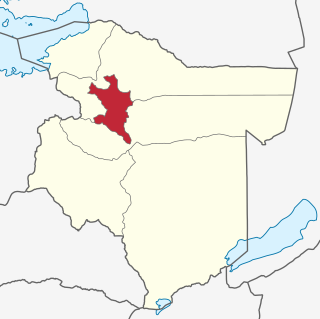
Maswa District is one of the five districts of the Simiyu Region of Tanzania Inhabited by Sukuma people. It is bordered to the north by Magu District and Itilima District, to the east by the Meatu District, to the south by the Kishapu District, and to the west by the Kwimba District. Its administrative centre is the town of Maswa.

Bariadi District is one of the five districts of the Simiyu Region of Tanzania, East Africa. As of 2022, the population was 383,385.
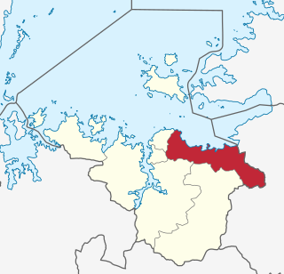
Magu District is one of the seven districts of the Mwanza Region of Tanzania, East Africa. Its administrative centre is the town of Magu on the Simiyu River. It is bordered to the north by Lake Victoria and Busega District, to the east by Bariadi District, to the south by Itilima District, Maswa District, Kwimba District and Misungwi District, and to the west by the city of Mwanza, which consists of Nyamagana District and Ilemela District.

Musoma Urban District is one of the seven districts of Mara Region of Tanzania. Its capital is the town of Musoma. The district is bordered to the north by Lake Victoria and to the south by Butiama District.

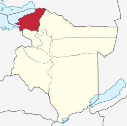
Musoma Rural District is one of the 9 districts of Mara Region of Tanzania. Mara region has the following Districts councils: Musoma district council, Rorya district council, Tarime rural, Tarime town council, Butiama, Serengeti, Bunda rural council, Bunda town Council and Musomal Municipal council. Its administrative centre is the town of Musoma. The district is bordered to the east by Butiama District, to the south by Bunda District and to the west and north by Lake Victoria.
Misungwi or Missungwi or Isungwi is a ward in Misungwi District, Mwanza Region, Tanzania. It is the biggest town on the trunk road from Mwanza to Shinyanga. In 2016 the Tanzania National Bureau of Statistics report there were 34,612 people in the ward, from 30,728 in 2012.

The following outline is provided as an overview of and topical guide to Tanzania:

Geita Region is one of Tanzania's 31 administrative regions. The region covers an area of 20,054 km2 (7,743 sq mi)."Geita Region Size". The region is comparable in size to the combined land area of the nation state of Slovenia. Geita Region is bordered to the east by Lake Victoria, Mwanza Region and Shinyanga Region. The region is bordered by Tabora Region and Kigoma Region to the south and south west respectively. Lastly, Gieta is borders Kagera Region to the west.
Bariadi is a Tanzanian town and regional capital of Simiyu Region, and the is also administrative seat of Bariadi District. Bariadi also refers to Bariadi Ward, another administrative unit in the district.

Simiyu Region is one of Tanzania's 31 administrative regions. The region covers a land area of 25,212 km2 (9,734 sq mi). The region is comparable in size to the combined land area of the nation state of North Macedonia. The region is bordered to the north by the Mara Region, to the south by the Shinyanga Region and Singida Region. Mwanza Region borders the region to the west through Lake Victoria, and Arusha Region to the east. The region is home to the Serengeti National Park, a UNESCO World Heritage Site, shared with Mara Region. The regional capital is the town of Bariadi. According to the 2022 national census, the region had a population of 2,140,497.
Maswa is a town in Simiyu Region of Tanzania. It is the administrative seat of Maswa District. And the Original Inhabited people are Sukama (Nyantuzu).

Butiama District is one of the seven districts of Mara Region of Tanzania. It is bordered to the north by Roya District across the Kirumi Bridge on the Mara river. Its administrative centre is the town of Butiama. Julius Nyerere was born in Butiama; the Mwalimu Nyerere Museum is located in his town of birth.

Itilima District is one of the five districts of Simiyu Region of Tanzania, East Africa. Its district capital is Lagangabilili. It is bordered to the north by Bariadi District, to the east by Ngorongoro District, to the south by Maswa District and Meatu District, and to the west by Magu District.
Lamadi is a town and a ward in Busega District of Simiyu Region, Tanzania. It is located on the shore of Lake Victoria. On 'dala dala' mini-busses in the area, the town's name is sometimes misspelled as 'Ramadi' the town have street (mitaa) that are Itongo, Makanisani, Majengo, Msekula Road, Mwalukonge and three village that are Lukungu, Mwabayanda and Kalago The main tribes in Lamadi Town are Sukuma, Jita,Kurya,Zanaki,Luo and Waha from Kigoma. The people like to visit Lamadi Town because is fevered by many attraction.

Kijereshi Game Reserve is a protected area located in Simiyu Region of Tanzania.