The Remarkables are a mountain range and skifield in Otago in the South Island of New Zealand. Located on the southeastern shore of Lake Wakatipu, the range lives up to its name by rising sharply to create a remarkable backdrop for the waters. The range is clearly visible from the nearby town of Queenstown.

Mount Taranaki is a dormant stratovolcano in the Taranaki region on the west coast of New Zealand's North Island. At 2,518 metres (8,261 ft), it is the second highest mountain in the North Island, after Mount Ruapehu. It has a secondary cone, Fanthams Peak, 1,966 metres (6,450 ft), on its south side.

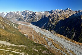
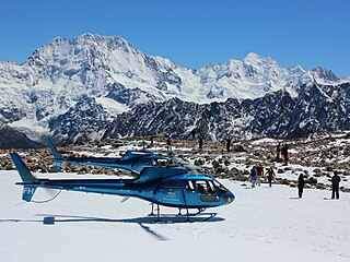
Mount Tasman is New Zealand's second-highest mountain, rising to a height of 3,497 metres (11,473 ft). It is located in the Southern Alps of the South Island, four kilometres to the north of its larger neighbour, Aoraki / Mount Cook. Unlike Aoraki / Mount Cook, Mount Tasman sits on the South Island's Main Divide, on the border between Aoraki / Mount Cook National Park and Westland Tai Poutini National Park. It is the highest point in Westland District.

Silberhorn is the fifth highest peak in New Zealand, rising to 3,300 metres (10,800 ft). It is located in the Southern Alps on the south ridge of Mount Tasman. Its name, "silver horn" in German, was probably given by William Spotswood Green in 1882 after its resemblance to Silberhorn in the Swiss Alps. Its Māori name, Rangirua, literally translates to 'second sky'. The first ascent of Silberhorn was in 1895 by Edward FitzGerald and his guide Matthias Zurbriggen.

Mount Burnett is a hill in Kahurangi National Park, in Golden Bay / Mohua, New Zealand.

The Paparoa Range is a mountain range in the West Coast region of New Zealand's South Island. It was the first New Zealand land seen by a European – Abel Tasman in 1642. Part of the range has the country's highest protection as a national park; the Paparoa National Park was established in 1987. Within that park, the Cave Creek disaster occurred in 1995.
The Volta Glacier is located in Mount Aspiring National Park in the Southern Alps of the South Island of New Zealand.

The Waitākere River is a river of the Auckland Region of New Zealand's North Island. It flows north then west from its sources in the Waitākere Ranges, reaching the Tasman Sea at Te Henga / Bethells Beach, to the south of Muriwai Beach. The upper reaches of the river are dammed to form the Waitākere Reservoir. The Waitākere Falls, just below the dam, are 95 metres (312 ft) high and the third highest waterfall in the North Island.

Dixon Peak, previously known as Mount Dixon, is the 23rd highest peak in New Zealand, rising to a height of 3,004 metres (9,856 ft). It is located in the Southern Alps of the South Island in the Mackenzie District, within Aoraki / Mount Cook National Park, and only a short distance from its more illustrious neighbour Aoraki / Mount Cook. The mountain is a popular peak for climbers, and is used as a practice run for ascents of Cook.
Mount Grey is a 934-metre (3,065 ft) mountain 15 kilometres west of Amberley in New Zealand. It is named after Sir George Grey who was governor of New Zealand when English surveyors climbed it in 1849. In Te Reo Māori, the mountain is called Maukatere, 'floating mountain', from where the spirits of the dead leave on the long journey to Cape Reinga.

Mount Arthur is in the Wharepapa / Arthur Range in the north western area of the South Island of New Zealand. Mount Arthur, named after Captain Arthur Wakefield, lies within Kahurangi National Park and has a peak elevation of 1,795 metres (5,889 ft).

Te Toiokawharu is a hill in the Waitākere Ranges of the Auckland Region of New Zealand's North Island. At 474-metres, it is the tallest peak of the Waitākere Ranges. The peak has a low prominence due to surrounding hills of similar sizes.
Mount Haast is a mountain summit located in the Southern Alps / Kā Tiritiri o te Moana, in the Westland District of New Zealand. The mountain was named after the German-born geologist Julius von Haast by James Mackay (1831–1912).

Mount Haast is a hill located near Springs Junction, in the Buller District of New Zealand. The hill is prominent when approaching Springs Junction from the south-east on State Highway 7, where the pyramidal shape gives the (wrong) impression of a volcanic cone. The hill was named after the German-born geologist Julius von Haast by James Mackay (1831–1912).
Mount Richardson is in northern Fiordland, in the Southland District of New Zealand, in the southwestern part of the country. The summit is 485 metres (1,591 ft) above sea level. The terrain around Mount Richardson is hilly to the northwest, and mountainous to the southeast.

The Butler Range, also known as North Butler Range, is a range located in the Westland District of the West Coast Region on the South Island of New Zealand. The range has also been known as Peaks of the Mist Range.
The Wharepapa / Arthur Range is a mountain range partially marking the boundary between the Tasman District and West Coast Region of New Zealand's South Island. The range is at the eastern extent of the Tasman Mountains which make up much of the island's northwest, making it easily visible from across the low-lying Waimea Plains further to the east. The range's location and its many uses make it a significant site for local Māori, including the iwi of Te Ātiawa and Ngāti Rārua. This includes the prominent peaks of Mount Arthur and Pukeone / Mount Campbell, which both hold mana in their own right and have become part of the identity of the aforementioned iwi.
Mount Teichelmann is a mountain summit located in the Southern Alps / Kā Tiritiri o te Moana, in the Westland District of New Zealand. The mountain was named after the Austrian surgeon and mountaineer Ebenezer Teichelmann.