Supaul district is one of the thirty-eight districts of Bihar, India. The town Supaul is the district's administrative headquarters. The district, which was split from the former Saharsa district on 14 March 1991, occupies 2,410 km2 (931 sq mi).

Bachhrawan is a town and nagar panchayat in Raebareli district in the state of Uttar Pradesh, India. It is the seat of a community development block. It is located on the main Raebareli-Lucknow road, at the intersection with roads leading to Maharajganj, Haidergarh, and Gurbakhshganj. The railway runs parallel with the Raebareli-Lucknow road, and there is a train station on the west side of town. First upgraded to municipal status in 1935, Bachhrawan hosts a Ramlila festival on Asvina Sudi 10, which involves a dramatic reenactment of the Ramayana. Vendors bring various everyday items to sell at the festival. As of 2011, the population of Bachhrawan is 12,521, in 2,359 households.
Mogalturru is a village in West Godavari district of the Indian state of Andhra Pradesh. It was a princely state during the British rule.

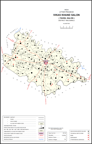
Salon is a town and nagar panchayat in Raebareli district in the Indian state of Uttar Pradesh. It serves as the headquarters of a tehsil as well as a community development block. Originally it was also the headquarters of the entire district, but they were moved after the Indian Rebellion of 1857. It is located a bit to the south of the Sai river, at the junction of the Raebareli-Pratapgarh and Jais-Khaga roads. Other roads lead to Dalmau, Manikpur, and Kunda. To the east is a large jhil.
Gudlavalleru is a village and Mandal in Krishna district of the Indian state of Andhra Pradesh. It is located on the Gudivada – Machilipatnam route.
Bantumilli is a village in the Krishna district of the Indian state of Andhra Pradesh. It is the mandal headquarters of Bantumilli mandal of Machilipatnam revenue division. It is well connected by road. It is located at 28 km from Machilipatnam, 50 km from Bhimavaram and 34 km from Gudivada.
Polavaram or Prolavaram is a village in Eluru district of the Indian state of Andhra Pradesh. It is located in Polavaram mandal of Jangareddygudem revenue division at about 35 km away from the banks of Godavari River. The Papi Hills and Polavaram Project are the major landmarks near the village.

Bhimadole is a village in Bhimadole mandal of Eluru district of the Indian state of Andhra Pradesh. Bhimadole BMD has its own railway station.
Iraga-varam is a village in the West Godavari district of the Indian state of Andhra Pradesh. It is located in Iragavaram mandal in Kovvur revenue division. The nearest railway station is Velpuru (VPU) located at a distance of 7 Km.
Jilugumilli or Jeelugu-milli is a village in West Godavari district of the Indian state of Andhra Pradesh.
Nidamarru is a village in West Godavari district of the Indian state of Andhra Pradesh.
Penumantra is a village in West Godavari district of the Indian state of Andhra Pradesh. The village is the site of the headquarters of Penumantra Mandal.
Poduru is a village and mandal headquarters of Poduru mandal in West Godavari district of the Indian state of Andhra Pradesh. The nearest railway station is located at Palakollu (PKO) at a distance of 7.4 km (4.6 mi).
Ganapavaram is a village in Eluru district of the Indian state of Andhra Pradesh.
Kukunoor is a village in Eluru District of the Indian state of Andhra Pradesh. It was in Khammam district, until the formation of Telangana state in 2 June 2014.
Paranda Tahsil is a tahsil (subdistrict) in Osmanabad district, Marathwada region in Maharashtra on Deccan Plateau of India. The town of Paranda is the administrative headquarters of the tahsil. There are seventy-two panchayat villages in Paranda Tahsil.
Tuljapur Tahsil is a tahsil/taluka (subdistrict) in Osmanabad district, Maharashtra on the Deccan Plateau of India. The town of Tuljapur is the administrative headquarters of the tahsil. There are 107 panchayat villages in Tuljapur Tahsil.
Manakawad is a village in Dharwad district of Karnataka, India.
Polavaram mandal is one of the 28 mandals in Eluru district of the Indian state of Andhra Pradesh. It is under the administration of Jangareddigudem revenue division and the headquarters are located at Polavaram. The mandal lies on the banks of Godavari River which separates it from East Godavari district and is bounded by Gopalapuram and Buttayagudem mandals.
Razole mandal is one of the 22 mandals in Konaseema district of Andhra Pradesh. As per census 2011, there are 13 villages in this mandal.


