
Stavanger is a city and municipality in Norway. It is the fourth largest city and third largest metropolitan area in Norway and the administrative centre of Rogaland county. The municipality is the fourth most populous in Norway. Located on the Stavanger Peninsula in Southwest Norway, Stavanger counts its official founding year as 1125, the year the Stavanger Cathedral was completed. Stavanger's core is to a large degree 18th- and 19th-century wooden houses that are protected and considered part of the city's cultural heritage. This has caused the town centre and inner city to retain a small-town character with an unusually high ratio of detached houses, and has contributed significantly to spreading the city's population growth to outlying parts of Greater Stavanger.

Bokn is a municipality in Rogaland county, Norway. It is located in the traditional district of Haugaland. The administrative centre of the municipality is the village of Føresvik, the only urban area in Bokn. Other villages in Bokn include Arsvågen, Trosnavåg, and Loten. The island municipality is mostly located on the three islands of Ognøya, Vestre Bokn, and Austre Bokn. All three main islands are connected to the mainland via a network of bridges.
Rennesøy is a former municipality in Rogaland county, Norway. It was merged into Stavanger municipality on 1 January 2020. It was located in the traditional district of Ryfylke. The administrative centre of the municipality is the village of Vikevåg. Other villages in Rennesøy included Askje and Sørbø. The municipality encompassed a number of islands on the south side of the Boknafjorden, north of the city of Stavanger.

Hundvåg is a borough of the city of Stavanger in Rogaland county, Norway. The borough includes a number of islands lying to the north of the main city centre of Stavanger. It includes the islands of Hundvåg, Sølyst, Grasholmen, Engøy, Buøy, Bjørnøy, Roaldsøy, and Ormøy. These islands are all connected together by bridges and they are connected to mainland Stavanger by the Stavanger City Bridge.
Engøy is an island in Stavanger municipality in Rogaland county, Norway. It is located in the "neighborhood" of Buøy in the borough Hundvåg, just north of the city centre. The island is almost completely urbanized with many houses on the east side and a lot of industry on the west side. There were 461 residents on the island in 2014.
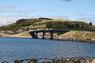
Stavanger City Bridge is a cable-stayed bridge in the city of Stavanger which is in the large Stavanger Municipality in Rogaland county, Norway. The bridge has one tower and it was one of the first larger cable-stayed bridge in Norway when it opened on 31 January 1978. The bridge crosses the Straumsteinsundet strait connecting the city centre of Stavanger to the small islands of Grasholmen and Sølyst. It is the main connection to the whole the borough of Hundvåg which is a series of islands that are all interconnected by small bridges.

Ryfast is a sub-sea tunnel system in Norway. The tunnel system is part of the Norwegian National Road 13 and it runs between the city of Stavanger, under a large fjord, and to the municipality of Strand in Rogaland county.

Sølyst is an island in Stavanger municipality in Rogaland county, Norway. The 0.13-square-kilometre (32-acre) island is located in the Buøy neighborhood in the borough of Hundvåg, just north of the city centre of Stavanger. It is connected to mainland Stavanger via the island Grasholmen and the Stavanger City Bridge. The island is hilly and rocky as well as heavily-treed. Most development is located on the south shore.

Grasholmen is an island in Stavanger municipality in Rogaland county, Norway. It is located in the Buøy neighborhood in the borough Hundvåg, just north of the city centre. The island is connected to mainland Stavanger via the Stavanger City Bridge and it is connected to the neighboring island of Sølyst by a short bridge.
Bjørnøy is a small island in Stavanger municipality in Rogaland county, Norway. The island is located in the borough of Hundvåg in the city of Stavanger. It is connected by bridge to the island of Hundvåg to the east, and it is also connected to the small islands of Roaldsøy and Ormøy to the south. The island is heavily populated and is covered with houses, although there are still a few larger green spaces left undeveloped.
Øyane is a neighborhood (delområde) in the city of Stavanger in Rogaland county, Norway. It includes many of the islands located to the east of the mainland portion of the city. The northern part includes the eastern half of the island of Åmøy which is in the borough of Tasta and the islands of Bjørnøy, Roadsøy, Ormøy, and Steinsøy are located in the borough of Hundvåg. The rest of Øyane, which includes the islands of Lindøy, Hellesøy, Kalvøy, Vassøy, and Langøy are all sparsely inhabited and not a part of any city borough. The neighborhood's area is 7.8 square kilometres and the population in 2005 was 2,125.

Bergsøya is an island in Gjemnes Municipality in Møre og Romsdal county, Norway. The island is located near the junctions of the Freifjorden, Kvernesfjorden, and Tingvollfjorden. The highest point on the 8.7-square-kilometre (3.4 sq mi) island is the 278-metre (912 ft) tall mountain Varden.

Aspøya is an artificial island in Tingvoll Municipality in Møre og Romsdal county, Norway. It is located between the Freifjorden and the Tingvollfjorden. The European route E39 highway crosses Aspøya and connects it to the nearby island of Bergsøya to the west by the Bergsøysund Bridge–part of the Krifast bridge and tunnel system which connects the town of Kristansund to the mainland. To the east, the E39 highway connects it to the Straumsnes peninsula in Tingvoll.
Bru is an island in Stavanger municipality in Rogaland county, Norway. The 3-square-kilometre (1.2 sq mi) island lies south of the Boknafjorden, just off the coast of the Stavanger Peninsula, along the Byfjorden. The highest point on the island is the 92-metre (302 ft) tall mountain, Brufjellet. The island sits in a group of islands with Sokn and Mosterøy to the north and Åmøy to the east.

Mosterøy or Mosterøya is an island in Rennesøy municipality in Rogaland county, Norway. The 12-square-kilometre (4.6 sq mi) island lies just southwest of the island of Rennesøy. The smaller islands of Sokn, Bru, and Åmøy lie to the south of Mosterøy and the islands of Klosterøy and Fjøløy lie to the west of Mosterøy. All of these islands are connected together and to the mainland city of Stavanger by a series of undersea tunnels and bridges. The Mastrafjord Tunnel connects Mosterøy to the island of Rennesøy and the Askjesund Bridge connects Mosterøy to the island of Sokn. Both the tunnel and bridge are part of the European route E39 highway.
Rennesøy is an island in Rennesøy municipality in Rogaland county, Norway. The 40.7-square-kilometre (15.7 sq mi) island lies on the south side of the Boknafjorden, surrounded by several other islands. The islands of Mosterøy, Klosterøy, and Åmøy lie to the south and Finnøy and Talgje lie to the northeast. The villages of Vikevåg and Sørbø are both located on the island. Vikevåg is the administrative centre of the municipality. The Hausken Church is located in Vikevåg and the 900-year old Sørbø Church is located in Sørbø.

Hundvåg is an island in Stavanger municipality in Rogaland county, Norway. The island is located in the borough of Hundvåg, just north of the city centre of Stavanger, separated by the Byfjorden. The 4.7-square-kilometre (1.8 sq mi) island is relatively flat and very urbanized. There were 9803 residents of the island in 2014. There is some agricultural areas as well as a lot of industry. The small island of Buøy is connected to the south side of Hundvåg by a small man-made isthmus. Hundvåg Church is located on the island.

Byfjorden is a fjord in Rogaland county, Norway. The 10-kilometre (6.2 mi) long fjord runs through the municipalities of Randaberg and Stavanger. The fjord begins at the Tungenes Lighthouse at the northern end of the Stavanger Peninsula and it flows south along the east side of the peninsula to the city of Stavanger. The islands of Bru, Åmøy, Hundvåg, Buøy, Engøy, Sølyst, and Grasholmen lie along the east side of the fjord. The fjord connects to the Boknafjorden at the north end.
The Hundvåg Tunnel is a road tunnel in Stavanger municipality in Rogaland county, Norway. The 5.5-kilometre (3.4 mi) long tunnel is located on the Norwegian National Road 13 highway. The tunnel goes under the Byfjorden and it connects the mainland of the city of Stavanger and the island of Hundvåg. The tunnel is part of the Ryfast tunnel network that is currently under construction with a planned opening in 2019. The western end of the tunnel connects to the Eiganes Tunnel in the city of Stavanger. Near the eastern end of the tunnel, there is an exit to the island of Buøy as well. The tunnel exits on the island of Hundvåg, just a short distance from the entrance to the Ryfylke Tunnel, a much longer tunnel crossing the fjord to Ryfylke.

Torget is an island in Brønnøy Municipality in Nordland county, Norway. The 16.4-square-kilometre (6.3 sq mi) island lies just off shore from the town of Brønnøysund on the mainland. It is connected to Brønnøysund by the Brønnøysund Bridge. There were 815 residents living on the island in 2015.
